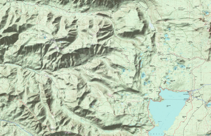
Waldo Lake Tr3590
Twitter Search
#WaldoLakeTrails
Overall: 8
Aerobic: 5
Technical: 5
Steepness: 4
Flow: 8
Singletrack: 100%
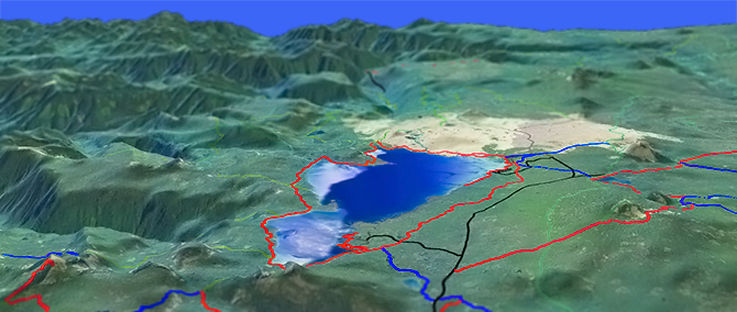
The Oregon Waldo Lake Trail is about as good as a lakeside ride can be, with enough terrain variation to keep it interesting.
Type
Loop
Length
Avg: 20.5mi
Ascent
Moderate
Elevation Change
TH:5400'
Avg Ascent:2450'
Ascent Incline
4%
Duration
Avg: 4hr
Weather
Forecast
NOAA
popup
USFS
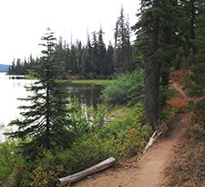
The main issue with lakeside rides is that lakes tend to be...kind of flat. As with Applegate Lake Da-Ku-Be-Te-De to Payette Tr970, Waldo Lake Tr3590 wanders far enough from shore to avoid excessive sleepiness.
Ding: The campground areas near the East and South side results in heavy foot traffic and overuse of those trail sections. Riding 8mi OAB from the North Waldo parking area to Koch Mountain Tr3576 is nearly as long as the full loop, avoiding the somewhat boring South and East side trail sections.
With plenty of area camping, Waldo Lake is suitable as a mountainbike destination, with enough other trails in the Waldo Lake area to justify repeat visits.
Most of the lake is surrounded by wilderness areas, so all of the connecting trails are off limits to riding, with the more vertically-challenging South Waldo Lake rides covered on the South Waldo Lake page.
Although it's possible to include Waldo Lake Tr3590 with Lemish to Charlton ride, using Charlton Lake Tr3593 as a connector trail, that ride works better when started at the Lemish TH.
As with riding in the Lemish Lake area, mosquitoes are ferocious in this area until August. Feel free to try the natural repellents, and avoid drinking carbonated drinks prior to riding, but Deet 100 may be the only protection from 'the swarm'.
Aside from the lakeside ride, there are two variations of a Metolius-Windigo Tr99 loop worth considering, one steep, one long and both including as much of Waldo Lake Tr3590 as desired.
The Twins to Charlton Loop
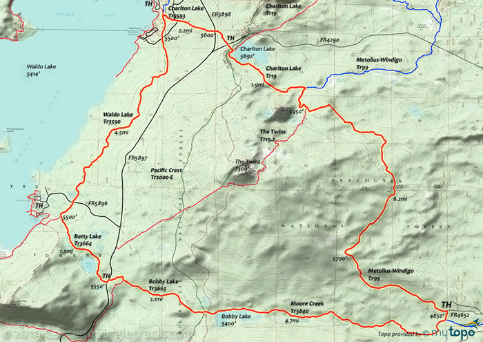
The 19.5mi (2900' ascent) Charlton-Twins-Waldo CCW loop includes a 1550' 3.7mi (8%) ascent, challenging but still a moderate ride.
The Twins Tr3595 should only be ridden west to east, as the Deschutes side has a loose, sandy trail surface, which would be very difficult to ascend.
Windigo-Waldo Epic
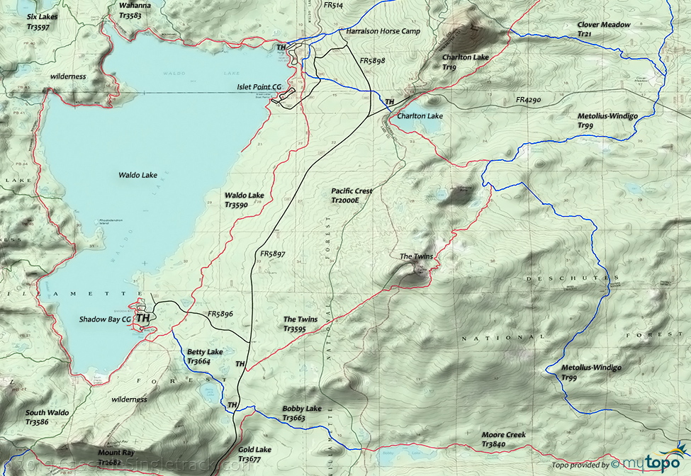
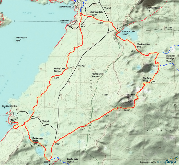
A 26mi (3050' ascent) CCW Loop of Metolius-Windigo Tr99, Charlton Lake Tr19/Tr3593, Waldo Lake Tr3590, Betty Lake Tr3664, Bobby Lake Tr3663 and Moore Creek Tr3840, covers all of the eastern Waldo Lake terrain. To complete the main ascent at the beginning of the ride, start from FR4652 (Pine Butte Loop Rd, accessed from Cascade Hwy near the Wickiup Reservoir North Davis Creek campground).
TH: FR400 is a spur from FR4652 and may not be passable, depending on recent maintenance. Metolius-Windigo Tr99 merges with FR400 at .6mi, to the end of the 1.8mi 'road'. Ascend 900' in 2.6mi (a very manageable 7% grade), the steepest ascent of the ride. After a gradual ascent, pass the Twins Tr3595 intersection on the left at 7.6mi.
8.2mi: Go left onto Charlton Lake Tr19 and ride 2mi to the Tr3593 intersection, then go left and ride to Waldo Lake.
11.8mi: Go left on Waldo Lake Tr3590, to Betty Lake Tr3664.
17.3mi: Cross FR5896 at 16.8mi, then go left on Betty Lake Tr3664. Cross FR5897 at 19.1mi and jog left to Bobby Lake Tr3663, which becomes Moore Creek Tr3840 at the 21.2mi PCT 4-way intersection. Descend 650' to the Metolius-Windigo Tr99 TH.
Directions: See Map. Park at the North campground Day Use Area. NW Forest Pass required right at the TH. View Larger Map. No Map?.
Loop Directions
where's waldo?
- TH: From the North campground Day Use Area
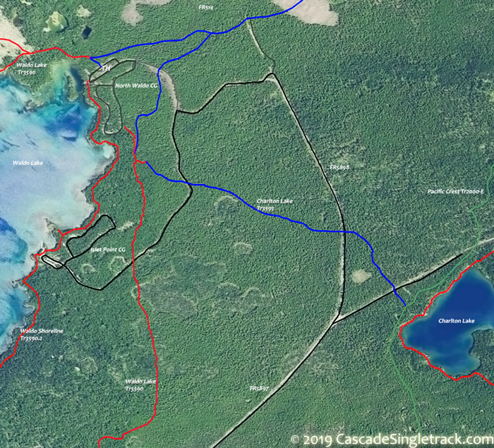
View of the Waldo Lake Northern Day Use TH, ride along the shoreline on Waldo Shoreline Tr3590.2 to the Breakwater boat ramp, just past the Islet campground (a Tr3590.2 spur continues for 1mi over flat shoreline terrain). Climb FR5898 to Waldo Lake Tr3590 at 1.7mi, then go right and continue the gradual ascent alongside the east shore of Waldo lake. Reach the ride summit at 3.6mi, having ascended a total of 550'. - 6.2mi: After a moderate descent and having passed Shadow Lake, cross FR5896. Pass the Betty Lake Tr3664 intersection on the left at 6.6mi, then approach the lake at 7.1mi, near Shadow Bay. See Map. There is an alternate route which avoids the Shadow Bay CG.
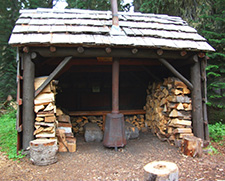
- 8.2mi: Pass the South Waldo Tr3586 intersection on the left, just past the South Waldo Shelter.
 Pass Tr3572 on the left at 8.8mi, with several steep climbs and increasingly technical trail conditions. Pass Tr3551 on the left at 10.6mi near Klovdahl Bay, then ascend the western slope. Pass a 4-way intersection with Tr3576, before descending past the western side of Green lake (the end of the technical section on this trail).
 - 17.4mi: Tr3583 merges from the left, cross the North Fork of the Willamette river, then pass another Tr3583 fork at 14.4mi. Pass Tr3555 on the left at 18.9mi.
- 19.6mi: Reach the Waldo Shoreline Tr3590.1 intersection. Go either way back to the TH, but there is likely to be more foot traffic by the lakeside.
Waldo Lake Wilderness Hiking
The Taylor Burn area trails at the north end of Waldo Lake are easily accessible from the North Waldo CG. FR514 is not maintained, so should be considered a jeep trail. From the north, FR1957 leads to the Skookum Creek CG, the northern Erma Bell Lakes Tr3563 TH. Jack Pine Way Tr3587 and a short section of Irish Mountain Tr3588 could be added to create a challenging day-hike loop from the Skookum Creek CG. Williams Lake Tr3589 is a primitive trail which passes through several meadows and includes several steep hikes in and out of drainages.
Blair Lake Tr3553 is a 15mi ridgeline trail at the northern boundary of this trail system and extends from FR514 to the Blair Lake CG, passing through a series of ridgeline prairie meadows along the way. Note: The North Fork of the Middle Fork Willamette River is at the bottom of a steep drainage and can usually be crossed on nearby logs found off to the right of the trail, but may be impassible or dangerous during the Spring runoff.
Whig & Torrey Way Tr3581 and Wahanna Tr3583 combine with Waldo Lake Tr3590 and FR514 to form a moderate day-hike loop around the Taylor Burn area.
Winchester Ridge Tr3596 and Six Lakes Tr3597 combine to form a challenging day-hike loop, with numerous small campsites alongside both trails.
Trail Index
This Ride
Betty Lake Trail 3664, Bobby Lake Trail 3663, Charlton Lake Trail 3593, Clover Meadow Trail 21, Metolius-Windigo Trail 99, The Twins Trail 3595, Waldo Lake Trail 3590
South Waldo Lake Area
Oakridge Area
Alpine Trail 3450, Aubrey Mountain Trail 3554, Box Canyon Trail 3660, Bunch Grass Trail 3559, Chucksney Mountain Trail 3306, Cloverpatch Trail 3457, Deception Butte Trail 3466, Eagles Rest Trail 3461, Eugene to Pacific Crest Trail 3559, Eula Ridge Trail 3463, Goodman Creek Trail 3461.1, Grasshopper Mountain Trail 3569, Grasshopper Spur Trail 3314, Hardesty Trail 3469, Hardesty Way Trail 1402, Larison Creek Trail 3646, Larison Rock Trail 3607, Lawler Trail 3473, Lone Wolf-Patterson Mountain Trail 3470, Lost Creek Trail 3462, McBee Trail 3523, Middle Fork Willamette Trail 3609, Mount June Trail 1400, North Fork Trail 3666, Salmon Creek Trail 4233, Sawtooth Trail 1401, South Willamette Trail 3465, Tire Mountain Trail 3485, Winberry Divide Trail 3476
Wilderness
Black Creek Trail 3551, Blair Lake Trail 3553, Cupit Mary Meadow Trail 3560, Erma Bell Lakes Trail 3563, Gander Lake Trail 3568, High Divide Trail 3572, Irish Mountain Trail 3588, Jack Pine Way Trail 3587, Lily Lake Trail 19.3, Koch Mountain Trail 3576, Pacific Crest Trail 2000, Salmon Lakes Trail 3585, Six Lakes Trail 3597, Spirit Lake Trail 3584, Verdun Trail 3686, Wahanna Trail 3583, Waldo Meadows Trail 3591, Waldo Mountain Trail 3592, Whig Torrey Way Trail 3581, Williams Lake Trail 3589, Winchester Ridge Trail 3596
XC Ski
Diamond Creek Falls Trail 3598, Fuji Creek Trail 4371, Gold Lake Snopark, Maiden Lake Trail 41, Marilyn Lakes Trail 3689, Salt Creek Falls Snopark, Waldo Lake Snopark
Campgrounds
Blue Pool Campground, Gold Lake Campground, Islet Point Campground, North Waldo Campground, Pebble Bay Campground, Princess Creek Campground, Shadow Bay Campground, Trapper Creek Campground
Trail Rankings
Ranking consistently applied to all of the listed trails.
- Overall Rating: Ride quality and challenge
- Aerobic: Ascent challenge
- Technical Difficulty: Terrain challenge
- Steepness: Average incline
- Flow: Uninterrupted riding
- Elevation Change: Total elevation gain
- Ride Difficulty: Terrain challenge




 Pass Tr3572 on the left at 8.8mi, with several steep climbs and increasingly technical trail conditions. Pass Tr3551 on the left at 10.6mi near Klovdahl Bay, then ascend the western slope. Pass a 4-way intersection with Tr3576, before descending past the western side of Green lake (the end of the technical section on this trail).
