
Fremont - Winema National Forest Mountain Bike and Hiking Trails
Fremont-Winema is a vast expanse of forest land, with plenty of high desert elevation to support great mountain biking.
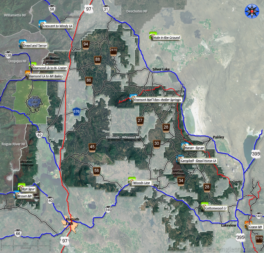
At the southern end of the Cascade Range, and less accessible than some of the nearby forest areas, Fremont still has plenty to offer and has a few trails worth noting.
Fremont National Recreational Trail
This trail (sometimes called Southern Oregon Intertie Trail) covers the eastern half of the Fremont-Winema National Forest, across a wide variety of terrain.
Due to forest fires and beetle-infected areas in past years, some segments near Winter Ridge area may be hard to distinguish. Other segments are outstanding but very primitive.
The 2020 Crane and Brattain Fires damaged Crane, Hanan and Campbell trails. See the NF Site for closures.
As always, it is best to call the local Ranger District for trail conditions and other restrictions prior to riding, as the NF website may not contain trip-specific details.
Fremont-Winema National Forest FRT #160 page.
Trail maps are on the Antler Springs Trail 160, Hanan Tr142 and Crane Mountain Trail 161 pages.
Fremont - Winema National Forest TrailFinder
Sort by column and/or search/filter by word (e.g. Select 'Name' from the pulldown menu, type in 'Rdg.', then click on any column header).
Interactive Map: Click on any trail or region. (Please refresh your browser if map fails to load.)
No Map? Browser settings and some browser extensions can prevent the maps from appearing. Please see Site Tech
Name | Nbr | Type | Climbing | Length: Mi | Ride Time: Hrs | State | National Forest | Ranger District | Incline of Ascent: Pct | Singletrack: Pct | TH Elev.: Ft | Elev. Chg.: Ft | Overall Rating | Aerobic | Flow | Page Status |
|---|---|---|---|---|---|---|---|---|---|---|---|---|---|---|---|---|
| Fort Rock State Park: Hole in the Ground | Nbr | Loop | Easy | 26 | 4 | OR | Deschutes | Fort Rock | 3% | 0 | 4350 | 1550 | 4 | 4 | 6 | Topo, Guide |
| Crescent Lk. to Windy Lk. | 3846 | Loop | Moderate | 23 | 4 | OR | Deschutes | Crescent | 4% | 100 | 4900 | 2900 | 6 | 5 | 7 | Topo, Guide |
| Diamond Lake to North Crater | 1410 | Loop | Easy | 16 | 3 | OR | Umpqua | Diamond Lake | 3% | 100 | 5350 | 1200 | 4 | 4 | 5 | Topo, Guide |
| Diamond Lake to Mount Bailey | 1451 | Loop | Intense | 10 | 3 | OR | Umpqua | Diamond Lake | 17% | 100 | 5200 | 3200 | 6 | 6 | 4 | Topo, Guide |
| Rye Spur | 3771 | OAB | Moderate | 13 | 3 | OR | Fremont | Klamath Falls | 9% | 100 | 5000 | 2850 | 6 | 6 | 6 | Topo, Guide |
| Cottonwood Creek | 127 | OAB | Easy | 10 | 2 | OR | Fremont | Lakeview | 5% | 100 | 5250 | 1500 | 6 | 6 | 6 | Topo, Guide |
| Rogger Meadow to Crane Mt. | 161 | OAB | Intense | 23 | 4 | OR | Fremont | Lakeview | 5% | 100 | 6500 | 3800 | 7 | 6 | 6 | Topo, Guide |
| Campbell - Dead Horse Lake | 139 | Loop | Moderate | 20 | 3.5 | OR | Fremont | Paisley | 6% | 100 | 5950 | 3800 | 6 | 6 | 6 | Topo, Guide |
| Hanan - Sycan | 142 | OAB | Moderate | 14.5 | 3 | OR | Fremont | Paisley | 4% | 100 | 6650 | 1500 | 6 | 5 | 6 | Topo, Guide |
| Antler Springs | 160 | OAB | Moderate | 18.5 | 2.5 | OR | Fremont | Silver Lk | 8% | 100 | 6400 | 2300 | 6 | 6 | 6 | Topo, Guide |
| Woods Line RTT | 100 | OAB | Easy | 64 | 6 | OR | Fremont | Bly | 3% | 0 | 4300 | 2700 | 4 | 6 | 4 | Topo, Guide |
| Brown Mt. | 1005 | Loop | Moderate | 20 | 4 | OR | Rogue | Klamath | 7% | 98 | 5000 | 2600 | 7 | 6 | 7 | Topo, Guide |
| Chinquapin Mt. | 45438 | OAB | Easy | 13 | 1.5 | OR | Rogue | High Cascades | 5% | 5 | 4600 | 1600 | 4 | 4 | 5 | Topo, Guide |
| Umpqua Rvr: Dread and Terror | 1414 | OAB | Moderate | 31.5 | 6 | OR | Umpqua | Clearwater Lake | 4% | 100 | 2400 | 6300 | 10 | 7 | 7 | Topo, Guide |
Trail Rankings
Ranking consistently applied to all of the listed trails.
- Overall Rating: Ride quality and challenge
- Aerobic: Ascent challenge
- Technical Difficulty: Terrain challenge
- Steepness: Average incline
- Flow: Uninterrupted riding
- Elevation Change: Total elevation gain
- Ride Difficulty: Terrain challenge
Ascent
Elevation and Incline
Easy

Moderate

Intense

Mtn Goat

Google Search
