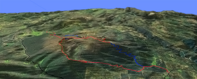
Campbell: Dead Horse Rim Tr139
Twitter Search
#GearhartWilderness

Overall: 6
Aerobic: 6
Technical: 6
Steepness: 5
Flow: 6
Singletrack: 100%
Dead Horse Rim Tr139 ascends to and crosses the length of the rim, to an 8100' summit.
The 2020 Brattain Fires damaged Hanan and Campbell trails. See the NF Site for closures.
As always, it is best to call the local Ranger District for trail conditions and other restrictions prior to riding, as the NF website may not contain trip-specific details.
Type
Loop
Length
Avg: 20mi
Ascent
Moderate
Elevation Change
TH:5950'
Avg Ascent:3800'
Ascent Incline
6%
Duration
Avg: 3.5hr
Weather
Forecast
NOAA
popup
USFS
The ride crosses the South Fork of Dead Cow Creek, Dead Horse Creek, and Augur Creek, and provides the only improved access into the Dead Horse and Augur Creek Roadless Areas and the Dead Horse Rim Whitebark Pine Research Area.
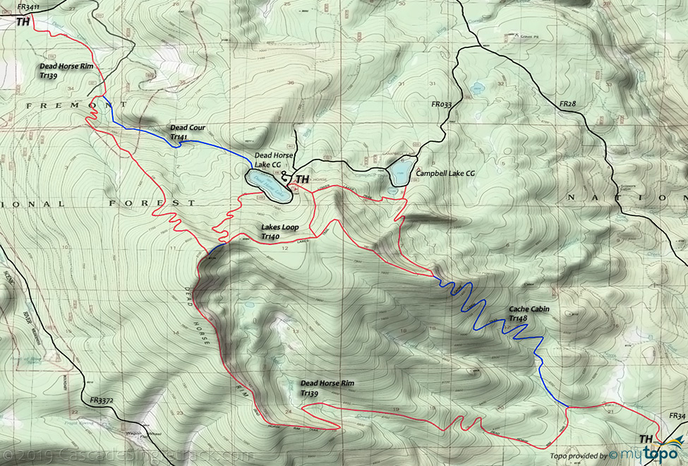
Lakes Loop Tr140 connects Dead Horse Rim Tr139 to Dead Horse Lake and Campbell Lake, creating some highly aerobic loop options for those able to handle the sometimes steep terrain.
Gearhart Mountain Tr100 provides the primary route through the Gearhart Mountain Wilderness area, with Boulder Springs Tr101 (previously called Deming Creek Trail) as a mid-point connector.
The Lookout Rock TH provides easy access to the Palisades, an area of rock outcrops, balancing rocks, and deeply incised rock walled mazes carved by nature.
Further up the train from the Lookout Rock TH, the Dome is a 300 ft. high bare rock monolith perched on the hillside like a giant gumdrop.
Warning: this terrain is not heavily used, so verify the trail considitions with the local ranger station prior to riding, or risk a steep backtrack if one of the trails is not passable.
Directions: To Deadhorse Lake CG: From Paisley follow SR31 north to Silver Lake, then go left on CR2-08 (mill street which becomes river road) 5.5mi to FR33, continuing 13.5mi to FR28 (north). Go 8.7mi to FR033 and 3.2mi to the CG. Note: FR3315 is an alternate route to FR28 from just outside Paisley. View Larger Map. No Map?.

Loop Directions
rim ride
- TH: From FR34, ascend to the rim, passing the Cache Cabin Tr148 intersection at 1.2mi (near the Auger creek crossing). Continue to ascend the increasingly steep terrain, crossing Dead Horse Creek at 4.7mi. Switchback to the rim and ascend to the 8100' ride summit, at the Lakes Loop Tr140 intersection.
- Note: The ride can be shortened at this point by taking Lakes Loop Tr140 to Cache Cabin Tr148 and Dead Horse Rim Tr139 back to the FR34 TH.
- 8mi: Descend from the rim through switchbacks, crossing Dead Cow Creek twice, then go right onto Dead Cow Tr141.
- 11.2mi: Ascend Dead Cow Tr141 2mi to Dead Horse Lake. Continue on the road to the Lakes Loop Tr140 TH. Ride towards Campbell Lake, then go right, through a notch and on to Cache Cabin Tr148 (the second ride summit).
- 16.1mi: Go left onto Cache Cabin Tr148 and descend 4mi through a series of switchbacks, to Dead Horse Rim Tr139 and back to the FR34 TH.
- This route is designed to have the primary ascent at the start of the ride, although Lakes Loop Tr140 involves a second ascent. Starting from the Lee Thomas TH could use Lakes Loop Tr140 and Dead Cow Tr141 as a short loop. Another option is to shuttle from Lee Thomas TH to FR34.
Trail Index
This Ride
Cache Cabin Trail 148, Dead Cow Trail 141, Dead Horse Rim Trail 139, Lakes Loop Trail 140
Gearhart Mountain Wilderness
Boulder Springs Trail 101, Gearhart Mountain Trail 100
Campgrounds
Campbell Lake Campground, Corral Creek Campground, Dead Horse Lake Campground, Lee Thomas Campground, Mitchell Monument Picnic Area, Sandhill Crossing Campground
Trail Rankings
Ranking consistently applied to all of the listed trails.
- Overall Rating: Ride quality and challenge
- Aerobic: Ascent challenge
- Technical Difficulty: Terrain challenge
- Steepness: Average incline
- Flow: Uninterrupted riding
- Elevation Change: Total elevation gain
- Ride Difficulty: Terrain challenge


