
Cascade Singletrack
Home of world class singletrack, the Cascade range extends from Lytton Mountain in British Columbia to Lassen Peak in Northern California.
CascadeSingletrack is a documentary project and map guide, covering the Cascade Range National Forests and focused on cross-country singletrack trails for mountainbiking, hiking and XC Skiing.
CascadeSingletrack uses metrics to identify 'destination' rides (those considered to be rides worthy of a day or overnight trip).
The ranking page describes the evaluation process, which has been consistently applied to all of the listed trails so that every ride can be compared to all of the other rides.
Site navigation and the TrailFinder can help identify the best trails for a particular riding style and driving distance, to see the rides you want alongside other rides that meet the same criteria.
The site currently contains 228 destinations, covering about 1000 rides (composed of thousands of trails).
Check out the Area Topo Map links for each ride, offering an expanded area view, featuring a high-resolution topo map with elevation, distances and landmarks. Use waterproof printer paper to print your own topo maps.
The trail pages include forest service links, which are a useful source of trail closure and maintenance info.

Trail Conditions
When exploring new areas, be sure to locate the ranger station nearest the trail, and call or stop by to talk to them about trail conditions, camping and other information. See the Pacific NW NF Site for active closures.
See the full-page Cascade Range Trails map, which shows all of the trailhead locations. Each trail page includes a link to the NF site, to get alerts and notices about local conditions or trail access. The trail pages often also include links to local trail advocacy groups, another good source for current conditions.
Missing Maps and Images?: Some browser extensions (such as ad blockers) can prevent the maps and other images from appearing. Please see Site Tech. The site is Ad-Supported, so please consider whitelisting the site in your Ad Blocker extension. The ads are intended to be minimal and non-intrusive (no pop up ads or videos).
Secure Browsing: The site supports secure browsing. switch to https
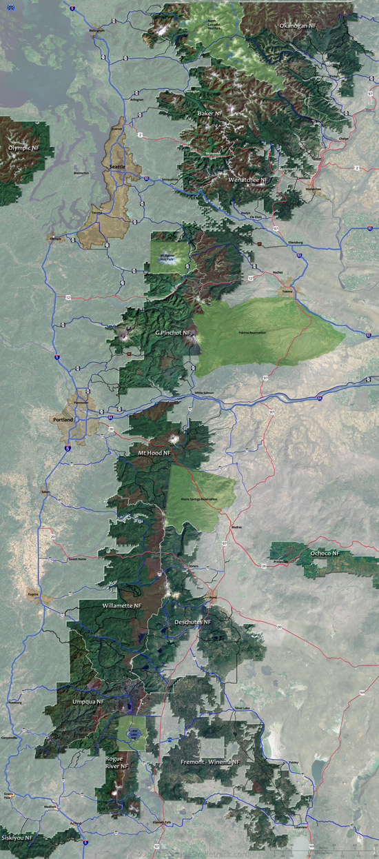
Interactive map: Select a National Forest area. Use the TrailFinder to search by trail name or some other attribute. Please refresh your browser if map fails to load.
Mountainbiking + Backcountry = Risk.
Warning: Mountain biking is inherently dangerous, even more so when riding on terrain which is beyond your skill level. Please don't interpret the ride rankings as a personal challenge.
People get killed or seriously injured on these trails every year, so consider the terrain and remoteness of any trail and take reasonable precautions.
Ride with other people when possible. The Links page includes various mountain bike associations, many of whom offer group rides, skills classes and advice on biking safety.
Destination Rides
The best rides are created from the right combination of climbing and downhill terrain.
Destination rides involve 3-8hrs of driving (from metro areas), so listings need to meet the following criteria:
- More than 60% singletrack ride time, and not shared with ORV.
- At least a two hour ride, over cross-country mtn biking terrain.
- Reasonably accessible and maintained. Caveats noted if it takes the local riders hours to get to the trailhead or if the Forest Service prefers to let the trail go 'au naturale'.
- An above average ranking.
Rides which don't meet these criteria may still be listed, or eventually added to the site, but marked as non-destination.
Not so much: Current conditions, Tree farms, State parks ...There are plenty of websites which cover state park and local trail systems, some of which are listed on our links page.
Gradually adding Hiking, Nordic terrain, OHV and Equestrian trails, where they are near biking trailheads. See the Cascade Guide menu for the PCT and Nordic Trail page indexes.
Weather: Local weather links are provided but do not indicate if the trail is washed out, snow covered, etc..
The riding season for a trail above 3000' is likely to be June - October. Above 4000' the season is likely limited to July-September.
Riding in the Spring or late Fall is usually limited to drier areas like Bend or trails that have southern exposure.
These trails also tend to dry out within a few days of rainfall.
The climbing difficulty as stated in text is always a little more up to date than the navigational maps, although the map trailhead locations are darn accurate.
Trail Rankings
Ranking consistently applied to all of the listed trails.
- Overall Rating: Ride quality and challenge
- Aerobic: Ascent challenge
- Technical Difficulty: Terrain challenge
- Steepness: Average incline
- Flow: Uninterrupted riding
- Elevation Change: Total elevation gain
- Ride Difficulty: Terrain challenge
Advocacy and MTB alliances
The links page includes a number of advocate groups, a great source of trail information, current conditions, trail maintenance opportunities and other group events.
The Washington-based Evergreen MTB Alliance wiki is an excellent source of information about (reasonably) current conditions, advocacy, history and everything else you might want to know. ![]() Central Oregon Trail Alliance and NW Trail Alliance cover portions of Oregon.
Central Oregon Trail Alliance and NW Trail Alliance cover portions of Oregon.
Please contribute to their efforts (updating wiki pages, trail crews, web maintenance, money...).
Most trails have a Twitter hashtag and search button, to help find and share ride experiences.
![]()
Visit Twitter for trail pagestatus updates.
Google Search
