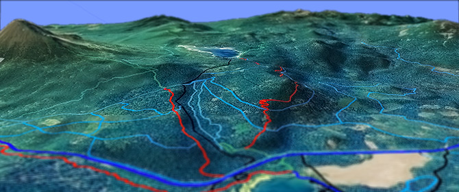
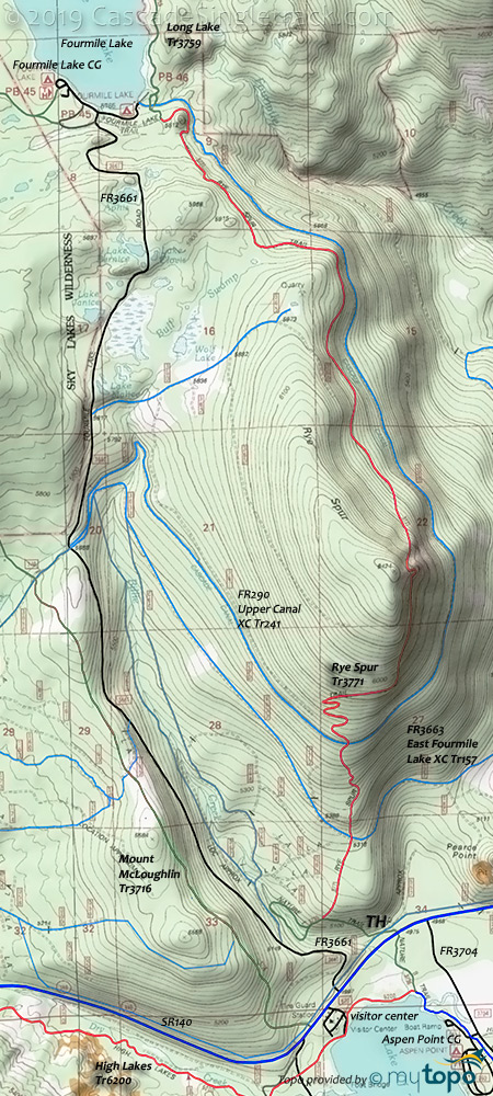
Rye Spur Tr3771

Overall: 6
Aerobic: 6
Technical: 5
Steepness: 6
Flow: 6
Singletrack: 100%
West of Klamath Falls Oregon, the Rye Spur Trail is an OAB ride, one of several popular ride options in the Lake of the Woods area.
Type
OAB
Length
Avg: 13mi
Ascent
Moderate
Elevation Change
TH:5000'
Avg Ascent:2850'
Ascent Incline
9%
Duration
Avg: 3hr
Weather
Forecast
NOAA
popup
USFS
Tweets
The non-wilderness portion of Mt McLaughlin Tr3716 and FR3661 could provide an easier ascent or an option for those wanting to extend the ride.
Upper Canal Tr241 is FR290 and runs alongside the Cascade Canal. Rye Spur Tr3771 crosses then parallels the Cascade Canal, to Fourmile Lake.
Also check out Brown Mtn Tr1005 and High Lakes Tr6200, which also includes the non-wilderness portion of Mountain Lakes Tr3721.
Nordic Activities
The area has a number of Sno Parks and forest roads which are used for nordic skiing and snowmobile use, with the following Sno Parks near SR140: Fish Lake Sno-Park, Summer Home Sno-Park, Summit Sno-Park, Great Meadow Sno Park and Fourmile Lake Sno-Park.
Choose from a wide variety of easy to technically challenging terrain.
For trail maps and other nordic info, check out Southern Oregon Nordic Club.
Directions: The Rye Spur TH is on the north side of SR140, 1mi west of the Great Meadow parking area, and .25mi past the Lake Of The Woods Resort and Aspen Point CG Rd. Alternately, park near Lake of the Woods and use the Sunset Tr3742 and Nature Tr3735 for access. View Larger Map. No Map?.

OAB Directions
lake to lake
- TH: Cross SR140 and FR550 then use .7mi of Nature Tr3735 to access Rye Spur Tr3771. Steep ascent to the top of Rye Spur, crossing FR3633 at 1.2mi and Upper Canal Tr241 at 1.8mi.
- 3.2mi: Crest the Rye Spur summit, having ascended 1450'. Relatively flat riding to Fourmile Lake, paralleling Cascade Canal.
- 6.4mi: Fourmile Lake.
Sky Lakes Wilderness
The area map covers the southern Sky Lakes Wilderness area, north of Fourmile Lake.
The area offers many loop and shuttle hiking opportunities, most accessed from Prospect or the Cold Springs TH on FR3651.
The Sky Lakes Wilderness area is also covered on the South Fork Rogue River Tr988 page.
Mt. McLoughlin Tr3716 leads to the sixth highest Cascade peak in Oregon at 9,495', ascending through a boulder strewn forest. The forest service notes that many people who leave the trail get lost, so watch for the tree markings. Boulder markings may not be reliable, as they may have moved.
From Fourmile Lake, Twin Ponds Tr993, Pacific Crest Tr2000-C and Cat Hill Way Tr992 can be combined with Blue Canyon Tr976 and Long Lake Tr3759 into several summit loop options.
Mosquitoes are ferocious in this area until August. Feel free to try the natural repellents, and avoid drinking carbonated drinks prior to riding, but Deet 100 may be the only protection from 'the swarm'. Expect some trailside poison oak and prepare as needed. Try using Tecnu before the ride.
Trail Index
This Ride
Rye Spur Trail 3771
Area
Sky Lakes Wilderness Hiking
Blue Canyon Trail 976, Cat Hill Way Trail 992, Long Lake Trail 3759, Meadow Lake Trail 976, Mount McLoughlin Trail 3716, Pacific Crest Trail 2000-C, Twin Ponds Trail 993
XC Ski
Cold Springs Trail 577, 8 Cold Springs Trail 142, East Fourmile Lake Tr157, Fourmile Lake Tr242, High Lakes Nordic Trails, Lower Canal Trail 240, Old Pelican Butte Trail 314, Pelican Butte Trail 15, Return Loop Trail 344, South Rye Tr45465, Upper Canal Trail 241
Campgrounds
Aspen Point Campground, Doe Point Campground, Fourmile Lake Campground, Sunset Campground
Trail Rankings
Ranking consistently applied to all of the listed trails.
- Overall Rating: Ride quality and challenge
- Aerobic: Ascent challenge
- Technical Difficulty: Terrain challenge
- Steepness: Average incline
- Flow: Uninterrupted riding
- Elevation Change: Total elevation gain
- Ride Difficulty: Terrain challenge


