
South Waldo Lake Tr3586
Twitter Search
#WaldoLakeTrails

Overall: 8
Aerobic: 7
Technical: 6
Steepness: 7
Flow: 6
Singletrack: 100%
South of Mount Ray, South Waldo Lake Tr3586 is open to mountain biking, with several good ride options.
Type
Loop
Length
Avg: 15mi
Ascent
Moderate
Elevation Change
TH:4850'
Avg Ascent:3500'
Ascent Incline
8%
Duration
Avg: 4hr
Weather
Forecast
NOAA
popup
USFS
East of Gold Lake, the north slope of Maiden Peak covers some epic terrain.
The Waldo Lake page covers the lake area.
To the west, Bunchgrass Rdg Tr3559 (part of the Eugene to Crest Trail system) is a great ridgeline ride, which connects to Fuji Mt Tr3674 using FR5883.
Some riders have used this route to create a too-epic 33.7mi (6600' ascent) Waldo to Oakridge shuttle ride.
The Fuji Mt Tr3674 to Mount Ray Tr2682 loop is a popular South Waldo loop, using the non-wilderness portion of South Waldo Tr3586 as a connector, and Gold Lake Tr3677 to return to the TH.
Forgoing the 2.2mi, 1300' South Waldo Tr3586 to Fuji Mountain summit ascent makes this a much more moderate 11mi (2000' ascent) ride.
Maiden Peak Epic

Similar to the Charlton to Lemish loop, this is an epic 31mi, ~7hr tour of lakes. To get most of the ascent out of the way at the beginning of the ride, the best route is CW from the Maiden Lake TH. The FR400 Moore Creek TH could also be used, or just start from Gold Lake CG and be ready for a mid-ride ascent to Maiden Lake.
An alternative to the excessively steep Maiden Peak Tr3681 grind is to ride Douglas Horse Pasture Tr4382 to the Pacific Crest Tr2000, then hike-a-bike .4mi (downhill) around North Rosary Lake to Maiden Lake Tr41.
Note: As of 2014, Metolius Windigo is impassible as it approaches Davis Lake, due to treefall. The forest roads shown are the fastest route back to the Maiden Lake TH.
TH: Ascend Maiden Lake Tr41 through old noble fir/mountain hemlock open forest, with some benched lava terrain. The ascent becomes more challening as the trail approaches the Maiden Peak intersection.
2.5mi: Bear left at the Maiden Peak intersection and descend to Maiden Lake. Note: Maiden Peak Tr3681 is hike-a-bike to the summit and then down to the Maiden Lake Tr41 intersection, more suitable as a hiking trail.
5.6mi: Go right onto the PCT Tr2000-E, over to the Skyline intersection. Bear left at the 4-way Skyline (Douglas Horse Pasture) intersection, as the PCT continues northward.
6mi: Moderate ascent for .5mi, then descend past the ski slope and on to the Maiden Peak Tr3681 intersection.
8.5mi: Go left at the Maiden Peak Tr3681 intersection and continue the rapid descent to the Gold Lake CG.
10.4mi: Go right onto FR500 and ride through the CG to Gold Lake Tr3677, then grind through the steady ascent to Bobby Lake Tr3663.
14.6mi: Go right onto Bobby Lake Tr3663 and enjoy a moderate descent to the PCT at 16.3mi. Go left (north) briefly, to Moore Creek Tr3840 then descend to Bobby Lake, Poverty Meadows and on to the Metolius-Windigo Tr99 South intersection.
21.3mi: Bear right onto Metolius-Windigo Tr99 and ride 1 mile to the 4 way intersection at the ridge (Metolius-Windigo Tr99 continues for another half of a mile before being obscured by an impassible forest of downed trees). Go right at the 4-way intersection, down to a small creek and up the hile to FR160. Go left and continue to FR4662, then go right for a mile to FR4664. Go left for 3 miles to the Maiden Lake TH road and back to the parking area.

Directions: See Map. NW Forest Pass required right at the TH. View Larger Map. No Map?.


Fuji-Ray Loop

- TH: From the Gold Lake campground or the Fuji Mt TH, ascend steeply for 1.7mi, then more gradually, passing Birthday Lake, Verde Lake and some smaller lakes, to the 3.8mi South Waldo Tr3586 intersection. The summit ascent starts with a climb to the base, then a steep, 1mi (16%) switchback ascent to the peak.
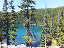
- 6mi: Descend from the summit, then go left onto South Waldo Tr3586 at 8.2mi. Traversing relatively flat, benched terrain, pass Upper and Lower Island Lake, then descend to Mount Ray Tr2682.
- 10.4mi: Go right onto Mount Ray Tr2682 and continue the descent, past Pothole Meadow then riding alongside Ray Creek. Cross FR5897 at 12.6mi, with a final descent to Gold Lake Tr3677.
- 13.1mi: Go right onto Gold Lake Tr3677 and gradually descend alongside Gold Lake Bog, then Gold Lake, to the TH.


Trail Index
This Ride
Douglas Horse Pasture Trail 4382, Fuji Mountain Trail 3674, Gold Lake Trail 3677, Maiden Lake Trail 41, Maiden Peak Trail 3681, Metolius-Windigo Trail 99, Moore Creek Trail 3840, Mount Ray Trail 2682, South Waldo Lake Trail 3586
Waldo Lake Area
Betty Lake Trail 3664, Bobby Lake Trail 3663, Bunch Grass Trail 3559, Charlton Lake Trail 3593, Clover Meadow Trail 21, Devils Garden Trail 3665, The Twins Trail 3595, Waldo Lake Trail 3590
Oakridge Area
Alpine Trail 3450, Aubrey Mountain Trail 3554, Box Canyon Trail 3660, Bunch Grass Trail 3559, Chucksney Mountain Trail 3306, Cloverpatch Trail 3457, Deception Butte Trail 3466, Eagles Rest Trail 3461, Eugene to Pacific Crest Trail 3559, Eula Ridge Trail 3463, Goodman Creek Trail 3461.1, Grasshopper Mountain Trail 3569, Grasshopper Spur Trail 3314, Hardesty Trail 3469, Hardesty Way Trail 1402, Larison Creek Trail 3646, Larison Rock Trail 3607, Lawler Trail 3473, Lone Wolf-Patterson Mountain Trail 3470, Lost Creek Trail 3462, McBee Trail 3523, Middle Fork Willamette Trail 3609, Mount June Trail 1400, Salmon Creek Trail 4233, Sawtooth Trail 1401, South Willamette Trail 3465, Tire Mountain Trail 3485, Winberry Divide Trail 3476
Waldo Lake Wilderness and Area Hiking
Abernethy Trail 3671, Black Creek Trail 3551, Deer Creek Trail 3672, High Divide Trail 3572, Koch Mountain Trail 3576, Lily Lake Trail 19.3, Pacific Crest Trail 2000-E, Verdun Trail 3686, Yoran Lake Trail 3849
XC Ski
Diamond Creek Falls Trail 3598, Fuji Creek Trail 4371, Gold Lake Snopark, Maidenfoot Nordic Trail 83887, Maiden Lake Trail 41, Maklaks Mountain Trail 83811, Marilyn Lakes Trail 3689, Salt Creek Falls Trail 3673, Waldo Lake Snopark
Campgrounds
Blue Pool Campground, Gold Lake Campground, Islet Point Campground, North Waldo Campground, Pebble Bay Campground, Princess Creek Campground, Shadow Bay Campground, Trapper Creek Campground
Trail Rankings
Ranking consistently applied to all of the listed trails.
- Overall Rating: Ride quality and challenge
- Aerobic: Ascent challenge
- Technical Difficulty: Terrain challenge
- Steepness: Average incline
- Flow: Uninterrupted riding
- Elevation Change: Total elevation gain
- Ride Difficulty: Terrain challenge
