
Patterson Mountain: Lawler Tr3473 - Lone Wolf Tr3470
Twitter Search
#LawlerTrail

Overall: 7
Aerobic: 7
Technical: 5
Steepness: 6
Flow: 6
Singletrack: 100%
The Oakridge Oregon Lawler Trail and Lone Wolf Tr3470 ride to Patterson Mountain offers slightly more moderate terrain than Hardesty Tr3469 or Eula Rdg Tr3463, yet is still challenging and long enough to be interesting.
Type
OAB
Length
Avg: 22mi
Ascent
Intense
Elevation Change
TH:950'
Avg Ascent:6100'
Ascent Incline
10%
Duration
Avg: 4hr
Weather
Forecast
NOAA
popup
USFS
Lawler Tr3473 ascends past rock outcrops and young conifer stands before reaching the ridgeline, leading to a large rocky knob with a great view. Aside from the featured OAB ride, Lawler Tr3473 and South Willamette Tr3465 are the basis for several CW Hardesty Mountain loops, descending on Eula Rdg Tr3463 or Hardesty Tr3469.
Lawler-Eula CW Loop: Lawler Tr3473 can be combined with FR1714, FR550 and Eula Rdg Tr3463 for 20.5mi CW Loop with a steep descent.
Lawler-Hardesty CW Loop: The epic 27mi (8100' ascent) Lawler Tr3473 to Hardesty Tr3469 ride starts at the Hardesty TH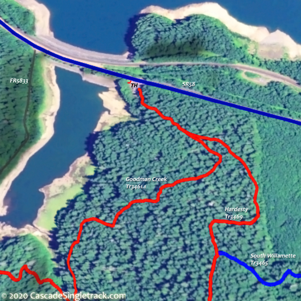
View of the Hardesty TH, riding South Willamette Tr3465 to the Lawler Tr3473 TH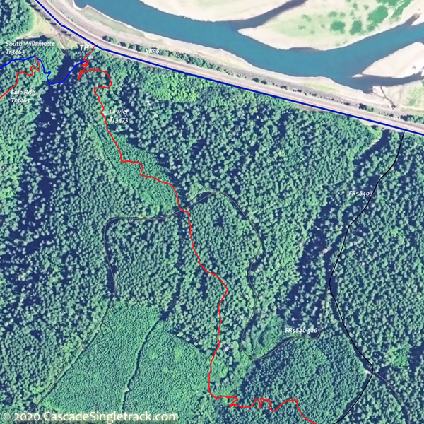
View of the Lawler, Eula Ridge TH, then FR1714, FR550 and Sawtooth Tr1401, descending Hardesty Tr3469. Five miles of the Lawler to Hardesty ride consists of FR1714 and FR550, and the use of South Willamette Tr3465 further increases the cross country aspect of this all-day loop.
Deception Butte Tr3466 is less used but well worth the effort. Note on the Area Map that the lower TH has been moved to FR5850. The trail is too steep for an ascent and the upper TH is accessed from FR5847 and FR549, for a 7.6mi, 2300' ascent from the Shady Dell CG.
Lawler-Eula semi-epic

TH: Ascend Lawler, as described in the main guide below. At 9.4mi pass FR555, then go left at the 9.9mi Lone Wolf/Patterson Mt Tr3470 intersection, then go right onto FR555 at 10.6mi.
11.3mi: Go right onto FR1714. Continue on FR550 at the 14.5mi 4-way Patterson Saddle intersection, continuing the ascent to the Hardesty Tr3469 intersection.
16.1mi: Go onto Hardesty Tr3469, just prior to the end of FR550. Pass the Hardesty Cutoff Trail 3469A intersection on the right and continue to the Sawtooth Tr1401 intersection, the second ride summit.
16.8mi: Go right onto Hardesty Tr3469, then go right onto Eula Rdg Tr3463 at the 17.4mi intersection. Try to remain wheels-down for the wild, steep 3mi Eula Rdg Tr3463 descent.

Lawler-Hardesty Epic

TH: From the Hardesty TH, pass the Goodman Cr Tr3461.1 intersection on the right at .4mi, then go left onto South Willamette Tr3465 at the Hardesty Tr3469 intersection.
1mi: Cross Crale Creek, then cross FR5835 at 1.3mi. Cross FR806 and FR509 then ascend a moderate switchback to FR510 at 2.7mi, cresting the ride summit at 3mi.
3.5mi: Switchback descent to Harper Creek, then switchback ascend a minor ridge, followed by a descent to North Creek at 4.6mi, and merger with Eula Rdg Tr3463 at 4.8mi.
4.8mi: Go left onto Eula Rdg Tr3463, then go right onto Lawler Tr3473 at 5.4mi. Ascend Lawler Tr3473, then go right onto FR1714, then FR550 to the Hardesty Tr3469 TH.
22.2mi: Go right at the Sawtooth Tr1401 intersection to remain on Hardesty Tr3469 and begin the descent to the TH. At 25.2mi, go right onto FR5835 and ride to the sharp right hand curve, where the singletrack switchbacks to the lower TH.

Directions: NW Forest Pass required right at the Lawler Tr3473 TH, or at the end of FR5840/FR531/FR535. View Larger Map. No Map?.

OAB Directions
long steady climb
- TH: From the Lawler Tr3473 TH, traverse the Schweitzer Creek drainage and on to FR5840, cross the road and resume the singletrack to FR531.
- 2mi: Trail merges with FR531. Go right and ascend FR531.
- 3.5mi: Go right at the fork, onto FR535. Terrain gets steeper.
- 4.9mi: Go left onto singletrack, or go to end of FR535 and find singletrack on the left. This is the alternate lower TH, so the ride could start from here.
- 7mi: After steep ascent, including some switchbacks, reach the first summit. Cross FR213 at 7.4mi, then begin final ascent.
- 8.1mi: Cross FR542 then cross FR543 at 8.3mi.
- 9.3mi: Go right at FR555 intersection to stay on the trail.
- 9.9mi: Go right at T intersection with Lone Wolf Tr3470, then go 1.2mi to the of trail, then enjoy the descent to the TH.

Trail Index
This Ride
Lawler Trail 3473, Lone Wolf-Patterson Mountain Trail 3470, South Willamette Trail 3465
Area
Aubrey Mountain Trail 3554, Alpine Trail 3450, Clark Butte Trail 3456.1, Cloverpatch Trail 3457, Deception Butte Trail 3466, Eagles Rest Trail 3461, Eugene to Pacific Crest Trail 3559, Eula Ridge Trail 3463, Goodman Creek Trail 3461.1, Hardesty Trail 3469, Hardesty Way Trail 1402, Jones Trail 3472, Larison Creek Trail 3646, Larison Rock Trail 3607, Lost Creek Trail 3462, Middle Fork Willamette Trail 3609, Sawtooth Trail 1401, Tire Mountain Trail 3485, Winberry Divide Trail 3476
Waldo Lake
Betty Lake Trail 3664, Bobby Lake Trail 3663, Douglas Horse Pasture Trail 4382, Fuji Mountain Trail 3674, Gold Lake Trail 3677, Maiden Lake Trail 41, Maiden Peak Trail 3681, Metolius-Windigo Trail 99, Moore Creek Trail 3840, Mount Ray Trail 2682, South Waldo Lake Trail 3586, The Twins Trail 3595, Waldo Lake Trail 3590
Campgrounds
Black Canyon Campground, Shady Dell Campground
Trail Rankings
Ranking consistently applied to all of the listed trails.
- Overall Rating: Ride quality and challenge
- Aerobic: Ascent challenge
- Technical Difficulty: Terrain challenge
- Steepness: Average incline
- Flow: Uninterrupted riding
- Elevation Change: Total elevation gain
- Ride Difficulty: Terrain challenge
