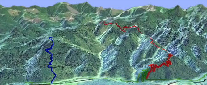
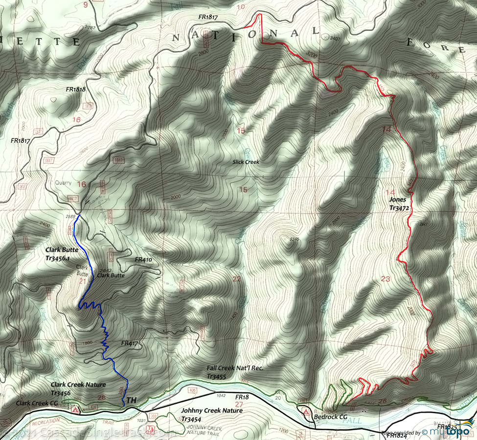
Clarke Butte to Jones Tr3472
Twitter Search
#ClarkButteTrail

Overall: 6
Aerobic: 7
Technical: 5
Steepness: 7
Flow: 6
Singletrack: 100%
The Trout Creek Oregon Clarke Butte to Jones Trail could be a CW or CCW loop, or an OAB on Jones Tr3472.
The 2020 Jones Creek fire has this terrain closed for now. The Fall Creek trail is also closed due to 2019 storm damage. See the NF Site for updates.
As always, it is best to call the local Ranger District for trail conditions and other restrictions prior to riding, as the NF website may not contain trip-specific details.
Type
Loop
Length
Avg: 13mi
Ascent
Moderate
Elevation Change
TH:1000'
Avg Ascent:4800'
Ascent Incline
12%
Duration
Avg: 3hr
Weather
Forecast
NOAA
popup
USFS
Many will find the 1.5mi, 20% Clark Butte Tr3456.1 entirely hike-a-bike.
Some hike-a-bike on this segment pays off with a 6mi Jones Tr3472 descent, so CW may be the best ride.
These two trails are connected at the top by FR1817 and at the bottom by the Fall Creek National Recreation Tr3455, although that trail is indicated to be hiker-only, so please use FR18 instead or take the bike for a 'hike' at that point. To shuttle, use FR1817 as the upper TH, riding to the Bedrock Campground.
Hiking: Fall Creek National Recreation Tr3455 is a generally level hike alongside Fall Creek, with a switchback to 1400' just past the Bedrock CG and many exit points along the nearly 15mi route. At Slick Creek there is a small cave and rock outcropping.
Clark Creek Nature Tr3456 includes interpretive signs and botanical variety. Also check out the nearby Johhny Creek Nature Tr3454.
Cowhorn Mountain Tr3458 ascends through a Douglas Fir forest to Little Cowhorn Mountain, and is steep and rough.
Directions: Either park at the Clarke Creek Campground or the Bedrock Campground. View Larger Map. No Map?.

Loop Directions
please no poaching
- TH: Steep 1.5mi Clark Butte Tr3456.1 climb.
- 2.5mi: Go right on FR1817.
- 4.8mi: Go right on Jones Tr3472 with 4mi of undulating terrain, traversing the headwaters of Bedrock Creek and Slick Creek, followed by 2mi of steady descent.
- 10.1mi: At Fall Creek National Recreation Tr3455, either bail out to FR18 at Bedrock Campground, or walk the bike on the trail. Observe signs at the Clark Cr Nature Tr3456 as well, as the forest service may prohibit riding.
Trail Index
This Ride
Clark Butte Trail 3456.1, Jones Trail 3472
Area
Alpine Trail 3450, Cloverpatch Trail 3457, Eagles Rest Trail 3461, Eugene to Pacific Crest Trail 3559, Eula Ridge Trail 3463, Goodman Creek Trail 3461.1, Hardesty Trail 3469, Hardesty Way Trail 1402, Larison Creek Trail 3646, Larison Rock Trail 3607, Lawler Trail 3473, Lone Wolf-Patterson Mountain Trail 3470, Lost Creek Trail 3462, Middle Fork Willamette Trail 3609, Sawtooth Trail 1401, South Willamette Trail 3465, Tire Mountain Trail 3485
Hiking
Clark Creek Nature Trail 3456, Cowhorn Mountain Trail 3458, Fall Creek National Recreation Trail 3455, Johhny Creek Nature Trail 3454
Campgrounds
Bedrock Campground, Big Pool Campground, Broken Bowl Campground, Clark Creek Campground, Dolly Varden Campground, Puma Campground
Trail Rankings
Ranking consistently applied to all of the listed trails.
- Overall Rating: Ride quality and challenge
- Aerobic: Ascent challenge
- Technical Difficulty: Terrain challenge
- Steepness: Average incline
- Flow: Uninterrupted riding
- Elevation Change: Total elevation gain
- Ride Difficulty: Terrain challenge


