
Lost Creek to Mount June Tr3462
Twitter Search
#HardestyTrail

Overall: 7
Aerobic: 7
Technical: 6
Steepness: 6
Flow: 7
Singletrack: 100%
The Oakridge Oregon Sawtooth Trail and Lost Creek Tr3462 are connector trails for the Hardesty Tr3469 Goodman Loop, with Hardesty Way Tr1402 and Mt June Tr1400 spur trails adding enough length to make this branched ridgeline trail system worth riding on its own.
Type
OAB
Length
Avg: 17mi
Ascent
Intense
Elevation Change
TH:2700'
Avg Ascent:6200'
Ascent Incline
10%
Duration
Avg: 4hr
Weather
Forecast
NOAA
popup
USFS

Sawtooth Tr1401 is an uneven ridgeline trail, connecting Hardesty Mountain and Mount June. Short, mostly gentle ascents and descents are joined by occasional level stretches through the ridge top saddles, with old growth forests to several open grassy meadows and rock bluffs.
The Mount June ascent is short but steep. The first 1.2mi of Hardesty Way Tr1402 ridgeline covers relatively flat terrain, so could be included as an additional spur ride.
Including Lost Creek Tr3462 in a ride which starts from the Sawtooth TH creates an inverted ride profile, so better to start from the FR511 Lost Creek TH.
Although not highlighted, it is possible to approach the Lost Creek Tr3462 TH from Lost Creek Rd and either Eagles Rest Rd (FR509) or FR512, but expect many intersections and uncertain road conditions.
As with other 'way' trails, Hardesty Way Tr1402 was designed to provide direct ridgeline access to the mountain and so covers steep terrain. The original 'way' trail is abandoned and now the lower 1.2mi follows FR161. The upper 1mi follows a steep ridgeline traversing a varied forest with occasional clearings which provide viewpoints to the west.
Mount June Tr1400 is a steady hike to the summit, with a 360 degree view of the Willamette Valley, the Coast Range and numerous Cascade Range peaks. The FR941 trailhead is accessed from FR511.

Directions: Lost Creek TH is on FR5833, but use the FR511 Lost Creek TH. Go 2.6mi then go left. Go straight onto FR509 at 4.75mi, to FR511, then go left onto FR511 and continue to the Lost Creek TH. View Larger Map. No Map?.

OAB Directions
many spurs

- TH: From the FR511 Lost Creek TH
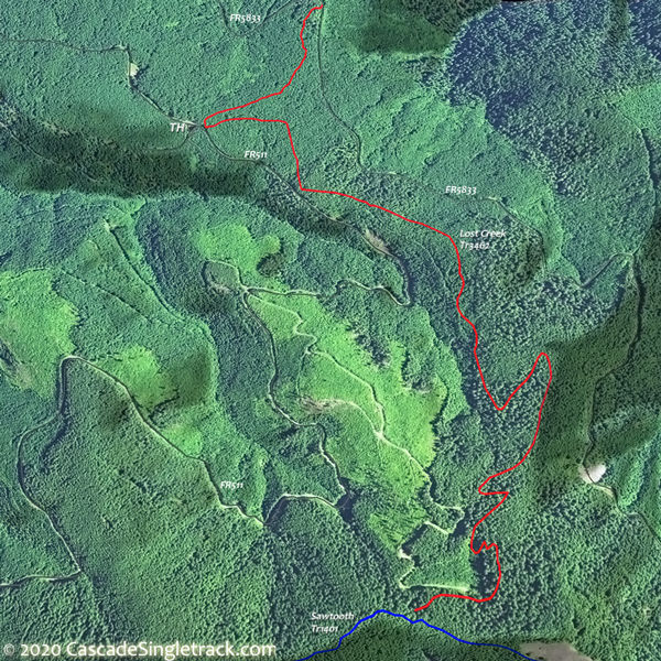
View of the Lost Creek TH, ascend 1400' on Lost Creek Tr3462. - 2.7mi: Go right on Sawtooth Tr1401, then ascend Mount June Tr1400, reaching the ride summit at 3.3mi. Return to Sawtooth Tr1401, passing the Lost Creek Tr3462 intersection on the left at 4.4mi, then continuing to Hardesty Way Tr1402.
- 5.3mi: Go right onto Hardesty Way Tr1402 and ride OAB to FR161, then return to Sawtooth Tr1401 and go right and ride to the FR550 TH.
- 11.6mi: From the Sawtooth Tr1401 FR550 TH, pass the Hardesty Tr3469 intersection on the right at 12.2mi, with an option to ride Hardesty Tr3469 OAB 1.2mi. Return on Sawtooth Tr1401 to Lost Creek Tr3462.
- 14.7mi: Go right on Lost Creek Tr3462 and return to TH.


Trail Index
This Ride
Hardesty Way Trail 1402, Lost Creek Trail 3462, Mount June Trail 1400, Sawtooth Trail 1401
Area
Adams Mountain Trail 1419, Alpine Trail 3450, Brice Creek Trail 1403, Clark Butte Trail 3456.1, Cloverpatch Trail 3457, Crawfish Trail 1421, Deception Butte Trail 3466, Eagles Rest Trail 3461, Eugene to Pacific Crest Trail 3559, Eula Ridge Trail 3463, Goodman Creek Trail 3461.1, Hardesty Trail 3469, Jones Trail 3472, Larison Creek Trail 3646, Larison Rock Trail 3607, Lawler Trail 3473, Lone Wolf-Patterson Mountain Trail 3470, Middle Fork Willamette Trail 3609, North Fork Trail 3666, South Willamette Trail 3465, Tire Mountain Trail 3485, Winberry Divide Trail 3476
Campgrounds
Black Canyon Campground, Shady Dell Campground
Trail Rankings
Ranking consistently applied to all of the listed trails.
- Overall Rating: Ride quality and challenge
- Aerobic: Ascent challenge
- Technical Difficulty: Terrain challenge
- Steepness: Average incline
- Flow: Uninterrupted riding
- Elevation Change: Total elevation gain
- Ride Difficulty: Terrain challenge
