
Grasshopper Mountain Tr3569 - Chucksney Mountain Tr3306
Twitter Search
#ChucksneyTrail

Overall: 7
Aerobic: 7
Technical: 6
Steepness: 7
Flow: 6
Singletrack: 100%
The Oakridge Oregon Grasshopper Mountain Trail is a rugged ridgeline ride near the northern Middle Fork ranger district boundary with Mckenzie River ranger district, extending along the Hiyu Ridge from Lowell mountain to Chucksney Mountain.
Type
Loop
Length
Avg: 25mi
Ascent
Intense
Elevation Change
TH:3800'
Avg Ascent:7300'
Ascent Incline
11%
Duration
Avg: 5hr
Weather
Forecast
NOAA
popup
USFS
A 5.5mi segment of non-wilderness McBee Tr3523 can also be ridden as an OAB.
The trail ascends at a steep 16% grade for the first mile from the northern FR1927 TH, which will prove excessive for most riders.
Ascending Chucksney Mtn Tr3306 from the Box Canyon TH offers a slightly more moderate approach, with the option of returning on Chucksney Mtn Tr3306 as well.
Those wishing to avoid the steep ascent can use the Grasshopper Spur Tr3314 TH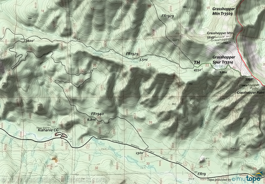
View of the Grasshopper Point TH to access the mid ride point, near Grasshopper Point, then ride OAB in either direction.
The ridgeline ride extends 2.7mi north and 5.2mi east, with the upper Chucksney Mtn Tr3306 TH as the turnaround point.
Nearby Indian Ridge Tr3315 (4.4mi) and Roaring River Ridge Tr3312 (2.6mi) are both open to biking, but are infrequently used and may not be cleared or rideable. Maybe something to check out if camping in the area.
Chucksney Mountain Loop, McBee OAB

For those seeking a shorter ride, a Chucksney Mtn Tr3306 to Grasshopper Mtn Tr3569 CCW loop offers a tough climb and fast descent.

The first 5.5mi of McBee Tr3523 is outside of the Three Sisters Wilderness area, creating a moderate 11mi (2000' ascent) OAB ride option.
The first 1.7mi is a 9% ascent, followed by relatively flat terrain out to the wilderness area.

Directions:Box Canyon TH: See Map. FR1927 TH: FR19 to FR1927 then 6.2mi south to the TH. View Larger Map. No Map?.

Loop Directions
steep ridgeline
- TH: From the Box Canyon campground, go right onto Chucksney Mtn Tr3306 and ascend 2300' over 4.5mi, to the Chucksney Mtn ride summit, then ride along the ridge to the Grasshopper Mtn Tr3569 intersection.
- 6mi: Go left onto Grasshopper Mtn Tr3569. After a moderate descent and climb, traverse to the next ridgeline at 8mi, then cross some rough terrain to Grasshopper Point.
- 11.2mi: Pass the Grasshopper Spur Tr3314 intersection on the left, then continue 2.7mi, past Grasshopper mountain to the point where the trail begins the descent to FR1927.
- 13.9mi: Turn around and head back to the TH. At the 21.8mi Chucksney Mtn Tr3306 intersection, extend the ride by several miles by using Chucksney Mtn Tr3306 for the descent, or enjoy the fast Box Canyon descent on Grasshopper Mtn Tr3569.

Three Sisters Wilderness Hiking

Once in the wilderness area, McBee Tr3523 is a key connector trail, leading into the Mink Lake basin and terminating in the Horse Lake area.
Crossing Way Tr3307 passes through dry lodgepole pine over level terrain for 3mi, then becomes a steep ascent into the McFarland Lakes area where it connects with the Pacific Crest Tr2000-E.
From the Frissel Crossing CG, South Fork McKenzie Tr3327 is a quiet, leisurely day hike through the second growth Douglas-fir alongside the South Fork of the McKenzie River.
Shale Ridge Tr3567 follows the gradually sloping drainage above Cedar Bog and through a grove of giant old cedar trees, then crosses the North Fork over a maze of logs and channels before ascending steeply via switchbacks to a ridgeline and into a forested area and meadow crossing.
Constitution Grove Trail 3675 wanders through old growth Douglas-fir on a river bench, above the current river level.
Blair Lake Tr3553 is the southern connector, following a meadow around the north end of Blair Lake, then ascends out of the basin and along a scenic ridgeline.
The primitive Williams Lake Tr3589 includes steep grades through several drainages and crosses several meadows on the way to Irish Mountain Tr3588 near Otter Lake.
Irish Mountain Tr3588 maintains a moderate grade through alpine forest to Otter Lake, followed by a small meadow then on to a ridge top. The trail then passes through rolling, rocky terrain with views of the Waldo Lake area, followed by flat meadows with large ponds.
Trail Index
This Ride
Chucksney Mountain Trail 3306, Grasshopper Mountain Trail 3569, Grasshopper Spur Trail 3314, McBee Trail 3523
Area
Three Sisters Wilderness Area Hiking
Blair Lake Trail 3553, Box Canyon Trail 3660, Cedar Swamp Trail 3538, Constitution Grove Trail 3675, Crossing Way Trail 3307, Elk Creek Trail 3510, Erma Bell Lakes Trail 3563, Fisher Creek Trail 3565, Frissel Crossing Trail 3320, Irish Mountain Trail 3588, Jack Pine Way Trail 3587, Mink Lake Basin Trail 3525, North Fork Trail 3666, Pacific Crest Trail 2000-E, Shale Ridge Trail 3567, South Fork McKenzie Trail 3327, Williams Lake Trail 3589
Campgrounds
Box Canyon Campground, Frissel Crossing Campground, Homestead Campground, Kiahanie Campground, Roaring River Campground, Skookum Creek Campground
Trail Rankings
Ranking consistently applied to all of the listed trails.
- Overall Rating: Ride quality and challenge
- Aerobic: Ascent challenge
- Technical Difficulty: Terrain challenge
- Steepness: Average incline
- Flow: Uninterrupted riding
- Elevation Change: Total elevation gain
- Ride Difficulty: Terrain challenge
