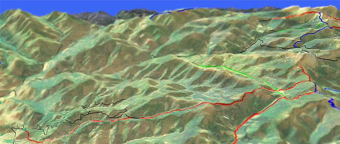
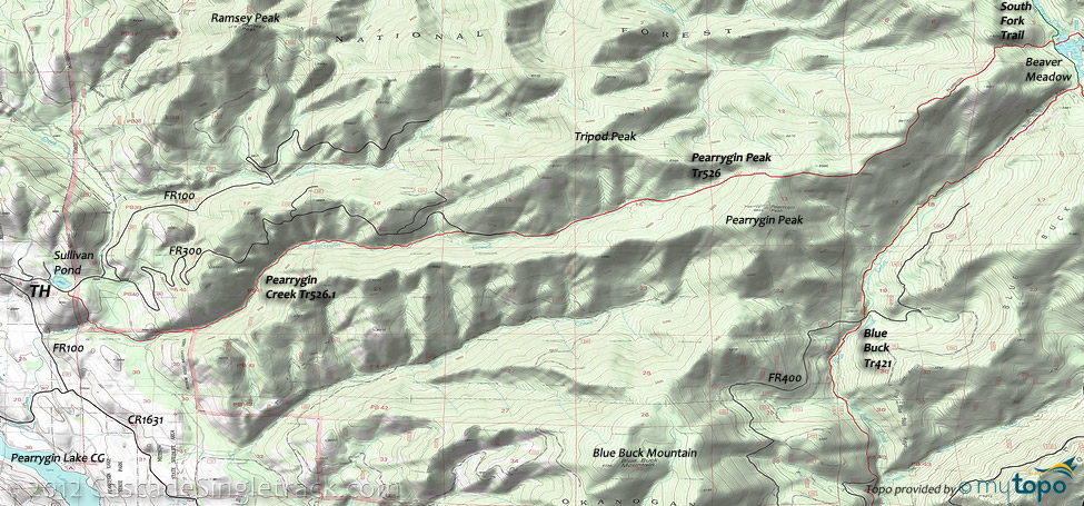
Pearrygin Ridge and Creek Tr526
Twitter Search
#pearrygincreek

Overall: 7
Aerobic: 8
Technical: 6
Steepness: 7
Flow: 8
Singletrack: 75%
Pearrygin Ridge and Creek Tr526 is a CW figure-eight loop from the Pearrygin Lake State Park, ascending FR300 to Pearrygin Ridge Tr526, returning on Pearrygin Creek Tr526.1, including some steep climbs and hillside exposure.
Type
Loop
Length
Avg: 25.5mi
Ascent
Intense
Elevation Change
TH:2950'
Avg Ascent:7500'
Ascent Incline
9%
Duration
Avg: 5hr
Weather
Forecast
NOAA
popup
USFS
At the top of Pearrygin Ridge Tr526, use Golden Stairway Tr354 to access Blue Buck Tr421 then use South Fork Trail for the Pearrygin Peak Tr526 return to FR300, then ride Pearrygin Creek Tr526.1 back to the TH.
The loop can be shortened to 16mi (4800' ascent) by turning around at Pearrygin Peak, but then what would you do with all that free time?
As a shuttle between Sullivan Pond and Beaver CG, Pearrygin Ridge Tr526 could be combined with Blue Buck Tr421 into an epic 25mi CW Loop (same 9% incline but only 6600' of climbing).
Directions: Go north on East Chewuch Rd to Pearrygin Lake State Park, then go past the park to the Methow Valley Wildlife Area. Take the first left onto FR100 and go to the Sullivan's Pond TH. View Larger Map. No Map?.

Loop Directions
i see cows
- TH: Climb FR100 past the intersection with FR200, then climb FR300 to the Pearrygin Ridge Tr526 TH.
- 6.2mi: Climb Pearrygin Ridge Tr526 to Golden Stairway Tr354.
- 13.2mi: Go right on Golden Stairway Tr354.
- 14mi: Go right on Blue Buck Tr421.
- 15.3mi: Go right on South Fork Trail.
- 15.8mi: Go left on Pearrygin Ridge Tr526, returning to FR300.
- 21.4mi: About 0.5mi on FR300, go left onto Pearrygin Creek Tr526.1. (TH is across the road from the watering tank)
- 25mi: Go right and climb the steep cattle trail when you reach the barbed wire gates. This trail and some doubletrack leads back to Sullivans pond.
Trail Index
This Ride
Blue Buck Trail 421, Pearrygin Creek Trail 526.1, Pearrygin Ridge Trail 526
Area
Bear Mountain Trail, Buck Mountain Trail, Cedar Creek Trail 476, Clark Ridge Trail 363, Early Winters Trail 522, Cutthroat Pass Trail 483, Freezeout Ridge Trail 345, Golden Stairway Trail 354, Lightning Creek Trail 425, Middle Fork Beaver Creek Trail 406, North Summit Trail 369, Pipestone Canyon Trail, Sun Mountain Trails, Tiffany Lake Trail 373, Twisp River Trail 440, West Fork Methow River Trail 480
Wilderness
XC Ski
Aqua Loop Trail, Beaver Pond Trail, Black Bear Trail, Bluejay Trail, Cabin Trail, Chickadee Trail, Criss Cross Trail, Fox Trail, Horse Trail, Inside Passage Trail, Kraule Trail, Lakeview Trail, Magpie Trail, Meadowlark Trail, Moose Trail, Little Wolf Trail, Overland Trail, Patterson Lake Trail, Pine Forest Trail, Rader Creek Trail, Raven Trail, Rodeo Trail, Sunnyside Trail, View Ridge Trail, Wolf Creek Trail, Yellowjacket Trail
Campgrounds
Trail Rankings
Ranking consistently applied to all of the listed trails.
- Overall Rating: Ride quality and challenge
- Aerobic: Ascent challenge
- Technical Difficulty: Terrain challenge
- Steepness: Average incline
- Flow: Uninterrupted riding
- Elevation Change: Total elevation gain
- Ride Difficulty: Terrain challenge


