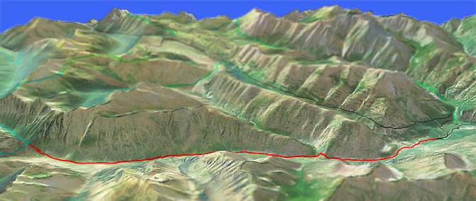
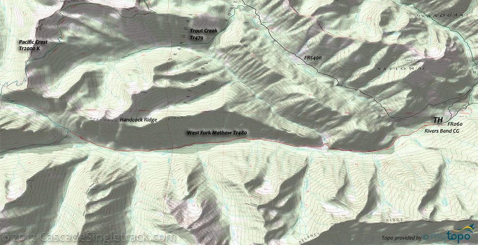
West Fork Methow River Tr480
Twitter Search
#methowriver

Overall: 6
Aerobic: 5
Technical: 3
Steepness: 4
Flow: 7
Singletrack: 100%
North of Wintrhop Washington, the West Fork Methow River Trail follows the Methow River in lodgepole pine and avalanche slide chutes, brush and meadows for 8mi.
Type
OAB
Length
Avg: 14.5mi
Ascent
Easy
Elevation Change
TH:2600'
Avg Ascent:1700'
Ascent Incline
4%
Duration
Avg: 3hr
Weather
Forecast
NOAA
popup
USFS
Trail
Review
The dozen creek crossings and the steep Handcock Ridge slope keep the ride interesting, but otherwise this is an easy OAB over a gradual incline.
If XC Skiing, be wary of the many Handcock Ridge avalanche chutes.
Ride 1mi from the River Bend CG on FR060 to the TH, or park at the TH if spaces are available.
Area Hiking: The area topo map shows the area wilderness hiking trails north of West Fork Methow River Tr480 to Boundary Tr533.
The area west to Ross Lake contains numerous popular loop options for the adventurous hiker.
From the SR20 Four Mile CG, East Creek Tr756 ascends the East Creek drainage, passing Boulder Creek Tr729 and the Gold Hill Mine at 3.5mi.
The trail beyond this point is not maintained or much used and crosses the ridgeline at MeBee Pass before merging with Pacific Crest Tr2000.
From the SR20 Canyon Creek TH, Jackita Ridge Tr738 extends north to Devils Ridge Tr752, through McMillan Park and Devils Park before traversing below the Jackita Ridgeline.
Crater Tr746 provides a spur to Crater Mountain and the Jerry Glacier.
West Fork Pasayten Tr472 and Robinson Creek Tr478 circumnavigate Pasayten Peak, Gold Ridge and Buckskin Ridge before merging at the Pasayten River just south of the Pasayten Guard Station.
Directions: US20W to the Mazama junction then turn right, then left at Mazama onto the Hart's Pass Road. Drive to River Bend CG and park .2mi further down the road. View Larger Map. No Map?.

OAB Directions
river ride
- TH: From the FR060 TH, cross Rattlesnake Creek at .6mi, cross several smaller creeks while ascending the gradual incline, then cross Trout Creek at 2.7mi. Cross 8 more creeks before reaching the Pacific Crest Tr2000 at 7.9mi.
- 7.2mi: Consider turning around prior to the final Brush Creek ascent to Pacific Crest Tr2000, or power up the steep drainage before turning back to the TH.
Trail Index
This Ride
West Fork Methow River Trail 480
Area
Wilderness
Boulder Creek Trail 729, Buckskin Ridge Trail 498, Buffalo Pass Trail 576, Cady Pass Trail 475, Chancellor Trail 754, Crater Mountain Trail 746, Devils Ridge Trail 752, East Bank Trail, East Creek Trail 756, Holman Creek Trail 472A, Jackita Ridge Trail 738, Little Jack Trail, Mill Creek Trail 755, Monument Trail 484, Pacific Crest Trail 2000, Panther Creek/Fourth of July Trail, Robinson Creek Trail 478, Rock Creek Trail 473, Slate Pass Trail 478A, Tatoosh Buttes Trail 485, Trout Creek Trail 479, West Fork Pasayten Trail 472, Whistler Trail 575
XC Ski
Aqua Loop Trail, Beaver Pond Trail, Black Bear Trail, Bluejay Trail, Cabin Trail, Chickadee Trail, Criss Cross Trail, Fox Trail, Horse Trail, Inside Passage Trail, Kraule Trail, Lakeview Trail, Magpie Trail, Meadowlark Trail, Moose Trail, Little Wolf Trail, Overland Trail, Patterson Lake Trail, Pine Forest Trail, Rader Creek Trail, Raven Trail, Rodeo Trail, Sunnyside Trail, View Ridge Trail, Wolf Creek Trail, Yellowjacket Trail
Trail Rankings
Ranking consistently applied to all of the listed trails.
- Overall Rating: Ride quality and challenge
- Aerobic: Ascent challenge
- Technical Difficulty: Terrain challenge
- Steepness: Average incline
- Flow: Uninterrupted riding
- Elevation Change: Total elevation gain
- Ride Difficulty: Terrain challenge


