Buck Mountain Trail
Twitter Search
#buckmtnwa

Overall: 5
Aerobic: 6
Technical: 5
Steepness: 7
Flow: 5
Singletrack: 55%
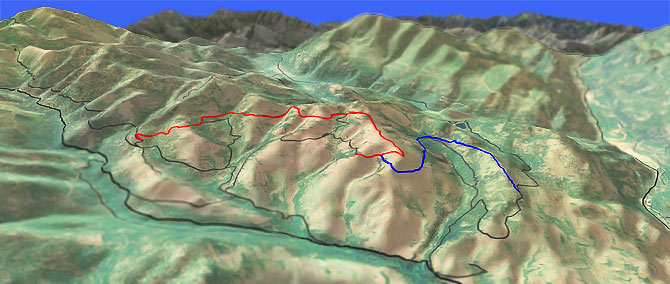
This Winthrop Washington ride is a CW loop which traverses the Buck Mountain ridgeline and First Creek drainage.
Type
Loop
Length
Avg: 13.5mi
Ascent
Intense
Elevation Change
TH:2600'
Avg Ascent:3450'
Ascent Incline
8%
Duration
Avg: 2.5hr
Weather
Forecast
NOAA
popup
Trail
Review
After using FR100 to ascend the First Creek drainage, traverse the sage covered hillside and pine forest, followed by a steep descent back to the TH.
Non-Destination: Although the trail is a favorite and easily accessed from Winthrop, the ride is relatively short and includes too much gravel road to be considered a destination ride.
The trail crosses some cattle grazing areas so please keep gates closed.
Pasayten Wilderness Hiking: Winthrop and the many nearby campgrounds are a perfect base for exploring the Pasayten Wilderness from July to September.
The West Fork Methow River Tr480 page has a wilderness map which extends to Ross Lake.
Boundary Tr533 is the main east-west Pasayten Wilderness crossing, connecting the major north-south trails such as Robinson Creek Tr478, Hidden Lakes Tr477, Larch Creek Tr502 and Lake Creek Tr500. The terrain varies from timbered valleys to long sidehills and high ridges, with much of the eastern section above the timberline.
Hidden Lakes Tr477 is a popular trail which leads to a string of fishing lakes with fine views for the first 7mi, through timber and valley bottom to the lakes. There is a pass between Middle and Big Hidden lakes with Big Hidden draining north to Canada, with the rest of the lakes draining south via the Lost River to the Methow River. Lost River can be reached by taking a side path about 100 yards south of Diamond Cr. The short, steep path reaches scenic meadows and sand bars along the river. Loop trips can be made with the Sheep Mountain area by using the East Fork Pasayten Tr451 over Dollar Watch Pass, or using McCall Gulch Tr548 or Boundary Tr533 over Bunker Hill. From the Sheep Mountain area Larch Creek Tr502 returns to the Hidden Lakes FR5130 TH.
Diamond Jack Tr514 is a Larch Creek Tr502 spur, just south of Diamond Creek, ascending the Diamond Creek Valley in timber to a 7100' pass before descending into the Fox Creek drainage to the junction with the Lake Creek Tr504. There are some scenic areas near the pass and two Fox lakes nearby can be reached via some unmarked trails. An unmarked trail to the ridge north of the pass leads to the top of Diamond Point, an old lookout site with views of the Ashnola drainage.
Directions: SR20 to Winthrop then go 5.7mi north on CR1213 (West Chewuch Rd). Go left on CR1251 (Cub Creek Rd), which becomes FR52. TH is at the FR025 intersection, just prior to the FR52 First Creek crossing. View Larger Map. No Map?.

Loop Directions
don't fence me in..
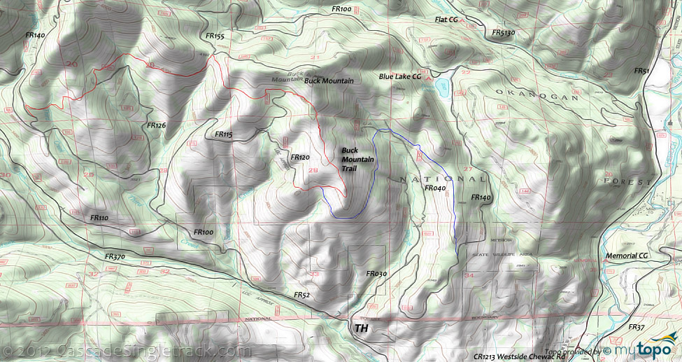
- TH: From the FR025 TH intersection, ascend FR52 (Cub Creek Rd) .8mi, then go right onto FR100 and continue the ascent to FR140. Pass the FR110 intersection on the left at 1.9mi, then pass the FR115 intersection on the right at 2mi and pass the FR126 intersection on the right at 2.6mi.
- 3.6mi: Go right onto FR140, at the Deer Country interpretive sign, then go right onto the doubletrack trail, which becomes singletrack. With the steepest ascent completed, cross Third Creek, then cross the FR126 intersection at 4.6mi, continuing to traverse just below the Buck Mountain ridgeline.
- 5.7mi: Cross several creeks then moderately climb to the FR155 intersection. Ascend to the 6.5mi FR115 intersection ride summit, followed by a steep ridgeline descent.
- 7.8mi: Bear right and drop off the ridgeline, to the 8mi T-intersection. Go left and ride around the hillside in a moderate descent, over to the First Creek drainage.
- 9.4mi: Cross FR045 and FR040 then cross First Creek and continue the moderate ridgeline descent.
- 10.8mi: Go right onto FR030 and descend the steep gravel road to the TH.
Trail Index
This Ride
Buck Mountain Trail
Area
Bear Mountain Trail, Blue Buck Trail 421, Cedar Creek Trail 476, Clark Ridge Trail 363, Early Winters Trail 522, Cutthroat Pass Trail 483, Freezeout Ridge Trail 345, Golden Stairway Trail 354, Lightning Creek Trail 425, Middle Fork Beaver Creek Trail 406, North Summit Trail 369, Pearrygin Peak Trail 526, Pipestone Canyon Trail, Sun Mountain Trails, Tiffany Lake Trail 373, West Fork Methow River Trail 480
Wilderness
Andrews Creek Trail 504, Billy Goat Trail 502A, Boundary Trail 533, Corral Lake Trail 502C, Dean Creek Trail 456, Diamond Jack Trail 514, Eightmile Trail 532, Falls Creek Trail 518, Hidden Lakes Trail 477, Lake Creek Trail 500, Larch Creek Trail 502, McCall's Gulch Trail 548, Monument Trail 484, East Fork Pasayten Trail 451, Robinson Creek Trail 478, Tatoosh Buttes Trail 485
XC Ski
Aqua Loop Trail, Beaver Pond Trail, Black Bear Trail, Bluejay Trail, Cabin Trail, Chickadee Trail, Criss Cross Trail, Fox Trail, Horse Trail, Inside Passage Trail, Kraule Trail, Lakeview Trail, Magpie Trail, Meadowlark Trail, Moose Trail, Little Wolf Trail, Overland Trail, Patterson Lake Trail, Pine Forest Trail, Rader Creek Trail, Raven Trail, Rodeo Trail, Sunnyside Trail, View Ridge Trail, Wolf Creek Trail, Yellowjacket Trail
Campgrounds
Buck Lake Campground, Camp Four Campground, Chewuch Campground, Falls Creek Campground, Flat Campground, Honeymoon Campground, Memorial Campground, Nice Campground, Ruffed Grouse Campground
Trail Rankings
Ranking consistently applied to all of the listed trails.
- Overall Rating: Ride quality and challenge
- Aerobic: Ascent challenge
- Technical Difficulty: Terrain challenge
- Steepness: Average incline
- Flow: Uninterrupted riding
- Elevation Change: Total elevation gain
- Ride Difficulty: Terrain challenge


