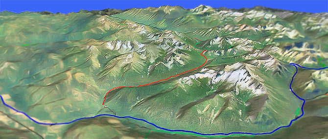
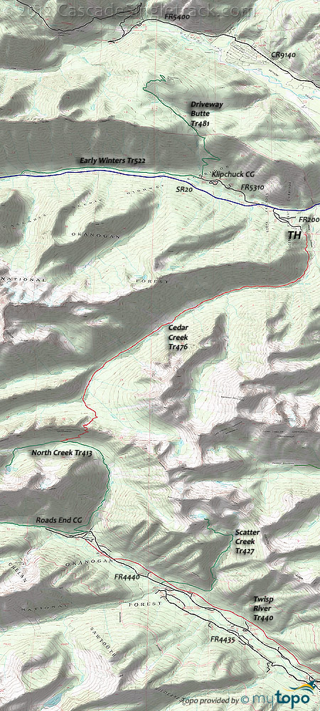
Cedar Creek Tr476
Twitter Search
#earlywinterswa

Overall: 8
Aerobic: 8
Technical: 8
Steepness: 7
Flow: 6
Singletrack: 100%
Beyond Cedar Creek Falls, the Winthrop Washington Cedar Creek Trail covers technical terrain which most riders will find challenging.
Type
OAB
Length
Avg: 13.5mi
Ascent
Intense
Elevation Change
TH:3100'
Avg Ascent:2500'
Ascent Incline
9%
Duration
Avg: 3hr
Weather
Forecast
NOAA
popup
USFS
The area around the falls has some cliff exposure, so be wary of the steep sidehills and blind corners on this trail...and the occasional rattlesnake.
Cedar Falls drops 50' in a series of falls, pouring from pool to pool.
The relatively low TH elevation ensures early season (May) riding unless the terrain is too wet.
With 14 creek crossings (each way), avoid this ride when wet, and expect hazardous conditions during Spring runoff and after heavy rainfall.
Open to bikes, the 3.4mi (500' ascent) Early Winters Tr522 extends from Klipchuck CG (between spaces 7 and 8) to Silver Star Creek, through forested terrain along the north side of Early Winters Creek.
At Abernathy Pass, Cedar Creek Tr476 enters the Chelan Sawtooth wilderness area and terminates at North Cr. Tr413, which loops around 75% of Gilbert Mt.
The 8.4mi (3200' ascent) Driveway Butte Tr481 OAB offers a challenging day-hike from the Klipchuck CG area, beginning as an old skid road then narrowing to singletrack on the way to a small pass, before ended in an open meadow below the butte.
Both USGS and Green Trails maps show a trail leading down the north side of Driveway Butte to the Methow River Trail, which was part of the old Pasayten sheep driveway, abandoned many years ago.
Not shown on the map, there are several meadow campsites 2mi south of Cedar Creek Falls on Cedar Creek Tr476.
Directions: NW Forest Pass required right at the TH. Go on SR20W for 18mi from Winthrop to FR5310-200 (.5mi east of the Klipchuck CG turn off). Trail begins near the gravel pit at the end of the road. View Larger Map. No Map?.

OAB Directions
ride to the wild
- TH: Traverse the hillside from the TH. Do not take 476A, which is an abandoned trail to Mudhole Lake, and which ascends directly from the TH. Cross the first of many creeks at 1.2mi, then pass Cedar Falls at 1.8mi.
- 3.4mi: After some hike a bike, complete the steepest ascent and pass several campsites next to a meadow as the ascent moderates.
- 6.3mi: Cross the West Fork Cedar Creek and continue climbing to the final Cedar Creek crossing, beyond which the trail ascends to Abernathy Pass and into the Chelan Sawtooth Wilderness area. Enjoy the technical downhill back to the TH, which presents it's own challenges along the way.
Trail Index
This Ride
Cedar Creek Trail 476, Early Winters Trail 522
Area
Wilderness
Blue Lake Trail 314, Driveway Butte Trail 481, Lone Fir Trail 535, North Creek Trail 413, Scatter Creek Trail 427, Slate Lake Trail 414, Wolf Creek Trail 527
XC Ski
Aqua Loop Trail, Beaver Pond Trail, Black Bear Trail, Bluejay Trail, Cabin Trail, Chickadee Trail, Criss Cross Trail, Fox Trail, Horse Trail, Inside Passage Trail, Kraule Trail, Lakeview Trail, Magpie Trail, Meadowlark Trail, Moose Trail, Little Wolf Trail, Overland Trail, Patterson Lake Trail, Pine Forest Trail, Rader Creek Trail, Raven Trail, Rodeo Trail, Sunnyside Trail, View Ridge Trail, Wolf Creek Trail, Yellowjacket Trail
Trail Rankings
Ranking consistently applied to all of the listed trails.
- Overall Rating: Ride quality and challenge
- Aerobic: Ascent challenge
- Technical Difficulty: Terrain challenge
- Steepness: Average incline
- Flow: Uninterrupted riding
- Elevation Change: Total elevation gain
- Ride Difficulty: Terrain challenge


