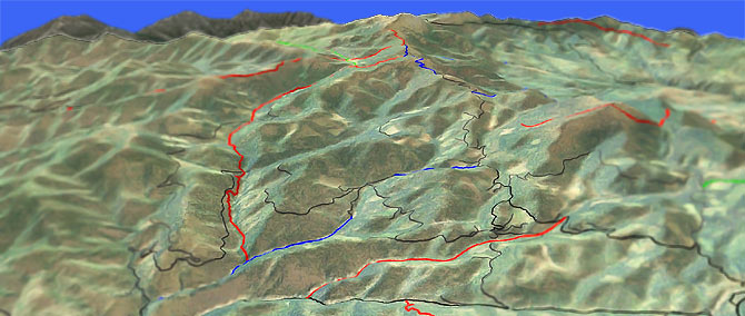
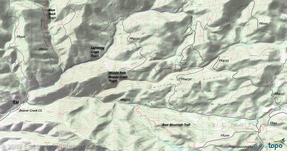
Lightning Creek Tr425
Twitter Search
#LightningCreekTrail

Overall: 8
Aerobic: 7
Technical: 7
Steepness: 7
Flow: 6
Singletrack: 65%
The ascent of this Twisp Washington ride is rated as Mtn Goat, due to the duration of the Starvation Mountain climb. It's a long way to the top...consider using a shuttle.
Type
Loop
Length
Avg: 14mi
Ascent
Mtn Goat
Elevation Change
TH:2900'
Avg Ascent:3500'
Ascent Incline
8%
Duration
Avg: 3hr
Weather
Forecast
NOAA
popup
USFS
Trail
Review
The typical 15mi (3800' ascent) Lightning Creek Tr425 CCW loop involves FR4225 to FR4230 to FR190, returning to the TH on Lightning Creek Tr425.
The use of 9.8mi of forest roads results in 35% singletrack by distance and much less by time, which does not meet the listing requirements for this site.
Due to it's sandy surface, Lightning Creek Tr425 is best ridden downhill.
Like the Lightning Creek Loop, the Starvation Mountain ascent can use Middle Fork Beaver Cr Tr406 to avoid about 5mi of forest road climbing, or use a shuttle to the top of Starvation Mountain.
This epic 26.4mi (8% incline, 6300' ascent) CCW loop starts with 2.2mi on FR4225 to Middle Fork Beaver Cr Tr406, then climb 7.4mi on FR4235 to Golden Stairway Tr354, returning on Blue Buck Tr421.
Golden Stairway Tr354 accesses the upper Pearrygin Cr Tr526 TH.
The Starvation Mountain loop can be extended by riding out to Pearrygin Cr Tr526 at Beaver Meadow, then using the South Fork Trail to return to Blue Buck Tr421.
If less distance is desired, a 10mi Blue Buck Tr421 OAB would also work nicely...or use a FR4235 shuttle.
There will be Cows: Blue Buck Tr421 gets some grazing use, so please leave the gates the way you find them.
The 13.7mi (8% incline, 3500' ascent, 4.8mi of forest road) intermediate rider alternative: Go on FR4225 to Middle Fork Beaver Cr Tr406 to FR4235, returning on Lightning Creek Tr425.
This may involve some hike-a-bike, depending on climbing abilities.
The very-accessible Bear Mountain Trail ride is a CW loop with 4.7mi of FR4225-FR200 leading to a 2.4mi downhill. Nearby FR202 gets some XC Ski use.
The 11mi (1500' ascent) CCW Pipestone Canyon loop is another easily accessible off-season option, or as something to add as a last-day ride. The Pipestone Canyon road is really a doubletrack jeep road, a fast descent from Campbell Lake, through the Methow Valley State Wildlife Area.
Eastside Hiking options: Nearby Beaver Lake Tr356 is an easy 1mi hike through the forest to Beaver Lake. Granite Mountain Tr355 and Shrew Creek Tr321 are open to ORV but cover some nice Scotch Creek State Wildlife area terrain.
Bring a topo map if shuttling to Starvation Mountain, as there are many, many forest roads in the area, which may turn the ride into something far more adventurous than intended...
Directions: Follow the signs to the airport on SR20E from Winthrop. Stay on the north side of the Methow River. Do not cross the bridge. Turn left on Bakke Hill Rd at the 6mi mark, then go to the Beaver Creek Rd. (Co. Rd. 1637) and turn left. Go 3mi to the Beaver Creek CG. Park inside CG by the gate at the end of the road. View Larger Map. No Map?.

Loop Directions
starvation mountain epic
- TH: From the Lightning Creek TH, Climb road FR4225 for 1.8mi.
- 2.2mi: Go left on Middle Fork Beaver Cr Tr406.
- 5.7mi: Go left at the 'T' onto FR4235, climbing to the Starvation Mountain summit.
- 10.4mi: Option: Go onto Lightning Creek Tr425 and return to the TH unless continuing to the summit.
- 13.1mi: Ride Golden Stairway Tr354 to Blue Buck Tr421. (If shuttling you could park here. If not...try not to think about it too much.)
- 15.6mi: At the ridge crest, go left onto Blue Buck Tr421. Trail is not well marked, although there might be a cairn at the TH.
- 16.8mi: South Fork Trail intersection. Go left at the fork to stay on the trail.
- 20.2mi: Cross the gravel pit and go right on FR400 then get back onto the trail.
- 25.4mi: Bear left to stay on the trail
- 25.1mi: Go left, then cross Beaver Cr, then bear left at the next fork. Turn right onto Lightning Creek Tr425, then cross Beaver Cr. again.
Trail Index
This Ride
Blue Buck Trail 421, Golden Stairway Trail 354, Lightning Creek Trail 425, Middle Fork Beaver Creek Trail 406, South Fork Trail
Area
Bear Mountain Trail, Buck Mountain Trail, Cedar Creek Trail 476, Clark Ridge Trail 363, Early Winters Trail 522, Cutthroat Pass Trail 483, Freezeout Ridge Trail 345, Granite Mountain Trail 355, North Summit Trail 369, Pearrygin Creek Trail 526.1, Pearrygin Ridge Trail 526, Pipestone Canyon, Shrew Creek Trail 321, Sun Mountain Trails, Tiffany Lake Trail 373, Tunnel Trail 353, West Fork Methow River Trail 480
Wilderness
Andrews Creek Trail 504, Beaver Lake Trail 356, Falls Creek Trail 518, Lake Creek Trail 500, Larch Creek Trail 502
XC Ski
Aqua Loop Trail, Beaver Pond Trail, Black Bear Trail, Bluejay Trail, Cabin Trail, Chickadee Trail, Criss Cross Trail, Fox Trail, Horse Trail, Inside Passage Trail, Kraule Trail, Lakeview Trail, Magpie Trail, Meadowlark Trail, Moose Trail, Little Wolf Trail, Overland Trail, Patterson Lake Trail, Pine Forest Trail, Rader Creek Trail, Raven Trail, Rodeo Trail, Sunnyside Trail, View Ridge Trail, Wolf Creek Trail, Yellowjacket Trail
Campgrounds
Beaver Campground, Buck Lake Campground, Camp Four Campground, Chewuch Campground, Falls Creek Campground, Flat Campground, Honeymoon Campground, Loup Loup Campground, Memorial Campground, Nice Campground, Pearrygin Lake Campground, Ruffed Grouse Campground
Trail Rankings
Ranking consistently applied to all of the listed trails.
- Overall Rating: Ride quality and challenge
- Aerobic: Ascent challenge
- Technical Difficulty: Terrain challenge
- Steepness: Average incline
- Flow: Uninterrupted riding
- Elevation Change: Total elevation gain
- Ride Difficulty: Terrain challenge


