Tiffany Lake Tr373

Overall: 6
Aerobic: 7
Technical: 6
Steepness: 8
Flow: 5
Singletrack: 60%
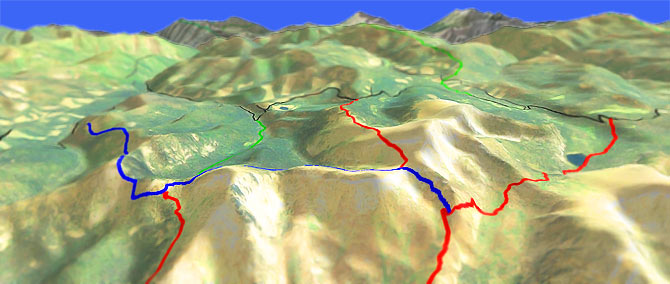
The Conconully Washington Tiffany Lake Trail offers a high-altitude ride around Tiffany Mountain, through the 7100' Honeymoon Pass and the 7600' Whistler Pass, with excellent views of the rugged North Cascades peaks and Pasayten Wilderness.
Type
Loop
Length
Avg: 12.8mi
Ascent
Intense
Elevation Change
TH:5750'
Avg Ascent:3400'
Ascent Incline
9%
Duration
Avg: 3.5hr
Weather
Forecast
NOAA
popup
USFS
Trail
Review
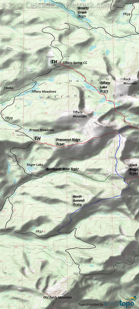
The typical 9.5mi (2500' ascent) CW loop consists of FR39, Tiffany Lake Tr373 and Freezout Ridge Tr345, and is a little too short to be a destination ride. The rating takes a hit for the amount of road climbing needed for any non-shuttle Tiffany Lake loop ride.
Intermediate riders will find the ridgeline terrain at times unrideable to the point of being dangerous, so be prepared for short sections of steep, technical terrain.
In addition to shuttling FR39 for the other described rides, Tiffany Lake Tr373 and North Summit Tr369 can be combined into an 8mi (2250' ascent) shuttle.
Well worth the drive, but be sure it is at the warmest, driest Summer month.
Aggressive climbers might try the 10.3mi (3500' ascent) Tiffany Lake Tr373, North Summit Tr369, Clark Ridge Tr363 CCW loop from the FR3820 Salmon Meadows CG.
Nearby Mutton Creek Tr391,Mutton Ridge Tr365 and Angel Pass Tr344 Orv trails are only worth checking out if camping at Salmon Meadows and looking for more terrain to explore.
The 9mi (1650' ascent) South Twentymile Tr512 OAB offers some additional ridgeline terrain, out to the South Twentymile Peak and back to FR39.
The 3.7mi (2100' ascent from FR570) Tunnel Tr353 is another local Orv trail, too steep for most riders but something to check out if camping in the area.
Pasayten Wilderness Hiking: A complete list of trails is shown in the Trail Index at the bottom of the page. The Buck Mountain page covers the wilderness area to the west.
Andrews Creek Tr504 forms the western boundary of this vast wilderness section, gently ascending the Andrews Creek river drainage to Spanish Camp, through mature forest and meadows. Twelve miles of trail were burnt in 2003 wildfire. This popular area contains many camp sites between Bald and Amphitheater Mountain to use as a base camp for day hikers.
Peepsight Tr525 follows Peepsight Creek to the headwaters near Peepsight Mountain, then ascends Crazy Man Pass, passes Rock Lake and rejoins the Andrews Creek Trail at Andrews Pass.
Coleman Ridge Tr505 ascends Ram Creek through lodgepole pine forest to meadow and subalpine fir areas near Meadow Lake, then traverses the west side of Coleman Ridge and around the east side of Remmel Mountain to Four Point Lake before descending through lodgepole pine forest to meet the Chewuch Tr510. Boulder fields and low trail use make sections between Meadow Lake and Four Point Lake difficult to follow, so watch for blazes and log cuts.
A popular cattle route, Chewuch Tr510 is a scenic river route through lodgepole pine, before ascending 2mi through subalpine and meadow areas. Chewuch Tr510 provides access to the popular Four Point Lake and Tungsten Mine areas. From this trail one can also reach the Horseshoe Basin area via Basin Creek Tr360 or the Cathedral Driveway to the Long Swamp Rd. Some of the trail burned in 2001 and 2003, presenting some treefall danger in high winds, and be sure to remain on the trail thru wet meadows, Upper Cathedral Lake and hummock areas below the Amphitheater, to avoid damaging these delicate ecosystems.
Tungsten Tr534 is a second growth lodgepole pine forest hillside traverse along Tungsten Creek. Tungsten mineral deposits were discovered in 1898, with the mine most active in 1915-18 and closed in the late 1950's. The 10-ton mill with a Humphrey Spiral, and miscellaneous mining debris are all that remain of the mine site.
Windy Peak Tr342 is a high ridge route through lodgepole pine, Douglas fir and spruce, to open meadows and alpine areas up and over Windy Peak. A side trail leads to the old summit lookout site.
Open to mountain bikes, North Fork Twentymile Tr560 begins in timber and maintains a steady uphill climb as it ascends the valley of Honeymoon Creek to two lookout towers, a modern lookout tower next to a 1920's log cabin groundhouse.
Directions: Okanogan County Road 2017 from Conconully, around the reservoir. Go 3mi then bear right on FR37 (FR42 continues straight), and continue for 21mi. After crossing Bernhardt Cr, go right on FR39 and go 8mi north to Tiffany Springs CG. Tiffany Lake Tr373 TH is across the road from the CG. View Larger Map. No Map?.

Loop Directions
big eight
- TH: From the Roger Lake FR025 TH (near the Bernhardt Mine Tr367 TH) ascend FR39 past the Freezeout Ridge Tr345 TH, then descend past Brown Meadows before the ascent to the Tiffany Springs CG.
- 6.1mi: Just past the CG go right onto Tiffany Lake Tr373, with an easy descent past Tiffany Lake followed by an increasingly tougher grind to the 8.2mi Honeymoon Pass. Descend from the pass to the North Fork Salmon Creek headwaters, then at 8.7mi hike-a-bike the very steep hillside to the North Summit Tr369 intersection.
- 9mi: Go right onto North Summit Tr369 continue the steep ascent to the 9.5mi Whistler Pass ride summit at the Freezeout Ridge Tr345 intersection, then traverse the moderate Clark Peak hillside terrain to the Bernhardt Mine Tr367 intersection.
- 10.8mi: Go right onto Bernhardt Mine Tr367 and descend 1000' in .7mi (a 27% grade). After a slightly more moderate descent, cross Bernhardt Creek at 12.4mi then descend to the TH.
Trail Index
This Ride
Bernhardt Mine Trail 367, Clark Ridge Trail 363, Freezeout Ridge Trail 345, North Summit Trail 369, South Twentymile Trail 512, Tiffany Lake Trail 373
Area
Bear Mountain Trail, Blue Buck Trail 421, Buck Mountain Trail, Golden Stairway Trail 354, Granite Mountain Trail 355, Lightning Creek Trail 425, Middle Fork Beaver Creek Trail 406, Pearrygin Creek Trail 526.1, Pearrygin Ridge Trail 526, Pipestone Canyon Trail, Shrew Creek Trail 321, South Fork Trail, Sun Mountain Trails
Wilderness
Albert Camp Trail 375, Andrews Creek Trail 504, Basin Creek Trail 360, Beaver Creek Trail 545, Beaver Lake Trail 356, Black Lake Ridge Trail 504B, Coleman Ridge Trail 505, Chewuch Trail 510, Clutch Creek Trail 343, Deer Park Trail 341, Falls Creek Trail 518, Fire Creek Trail 561, Lake Creek Trail 500, Larch Creek Trail 502, Lesamiz Trail 565, Little Andrews Trail 537, Long Draw Trail 340, Middle Fork Trail 387, North Fork Twentymile Trail 560, Peepsight Trail 525, Smarty Creek Trail 371, Thirtymile Creek Trail 520, Tungsten Trail 534, Twentymile Creek Trail 521, Windy Creek Trail 362, Windy Peak Trail 342
Orv
Angel Pass Trail 344, McKay Trail, Muckamuck Trail 346, Mutton Creek Trail 391, Mutton Ridge Trail 365, Tunnel Trail 353
Campgrounds
Andrews Campground, Beaver Campground, Buck Lake Campground, Camp Four Campground, Chewuch Campground, Falls Creek Campground, Flat Campground, Honeymoon Campground, Long Swamp Campground, Loup Loup Campground, Memorial Campground, Nice Campground, Pearrygin Lake Campground, Ruffed Grouse Campground, Salmon Meadows Campground, Tiffany Spring Campground
Trail Rankings
Ranking consistently applied to all of the listed trails.
- Overall Rating: Ride quality and challenge
- Aerobic: Ascent challenge
- Technical Difficulty: Terrain challenge
- Steepness: Average incline
- Flow: Uninterrupted riding
- Elevation Change: Total elevation gain
- Ride Difficulty: Terrain challenge


