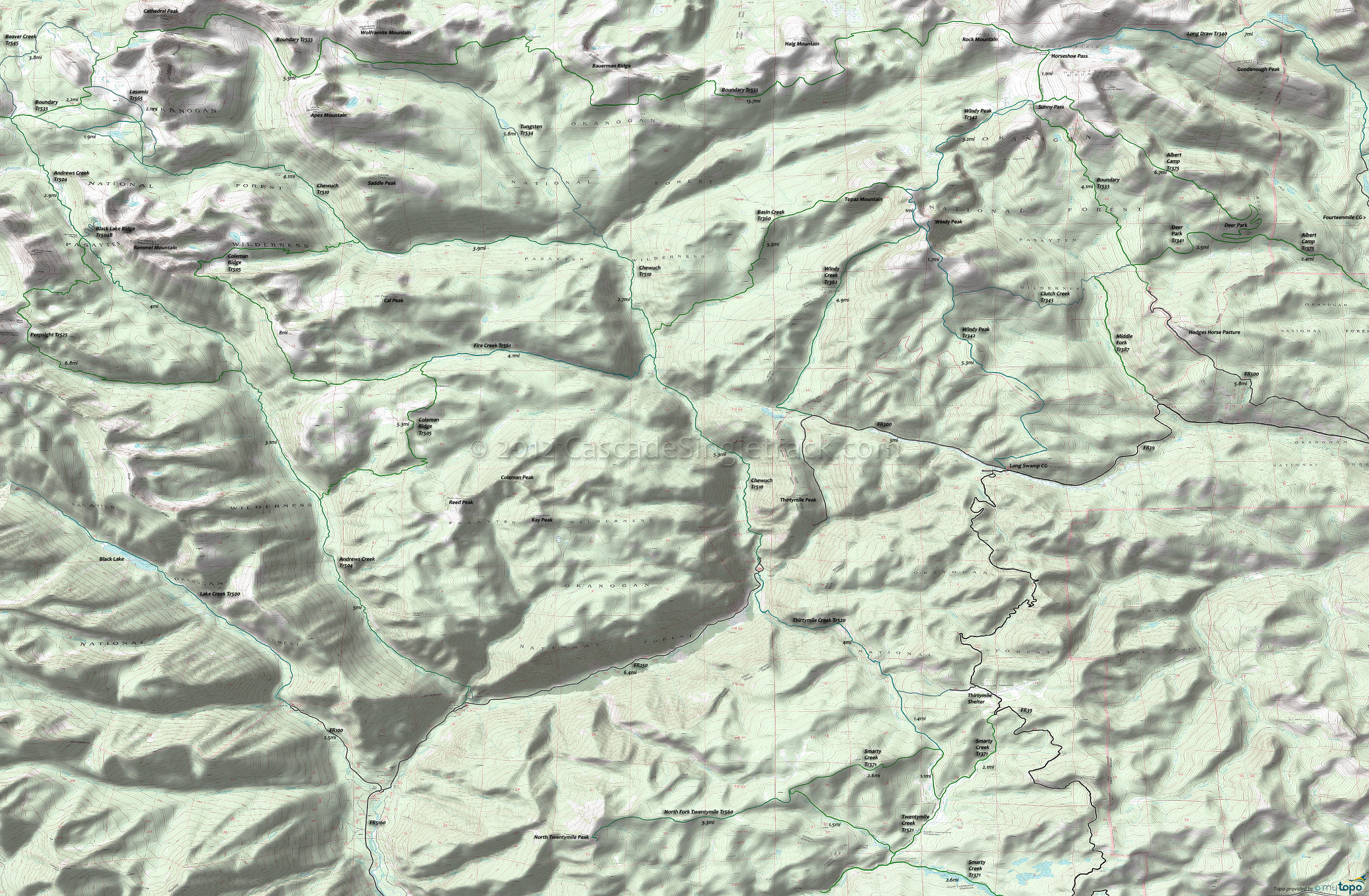
Andrews Creek Trail 504, Coleman Ridge Trail 505 and Chewuch Trail 510 Area Hiking Topo Map
Map includes: Andrews Creek Trail 504, Basin Creek Trail 360, Beaver Creek Trail 545, Coleman Ridge Trail 505, Chewuch Trail 510, Long Draw Trail 340, Peepsight Trail 525, Windy Peak Trail 342 Hiking Trails.
Pasayten Wilderness Hiking: A complete list of trails is shown in the Trail Index at the bottom of the page. The Buck Mountain page covers the wilderness area to the west.
Andrews Creek Tr504 forms the western boundary of this vast wilderness section, gently ascending the Andrews Creek river drainage to Spanish Camp, through mature forest and meadows. Twelve miles of trail were burnt in 2003 wildfire. This popular area contains many camp sites between Bald and Amphitheater Mountain to use as a base camp for day hikers.
Peepsight Tr525 follows Peepsight Creek to the headwaters near Peepsight Mountain, then ascends Crazy Man Pass, passes Rock Lake and rejoins the Andrews Creek Trail at Andrews Pass.
Coleman Ridge Tr505 ascends Ram Creek through lodgepole pine forest to meadow and subalpine fir areas near Meadow Lake, then traverses the west side of Coleman Ridge and around the east side of Remmel Mountain to Four Point Lake before descending through lodgepole pine forest to meet the Chewuch Tr510. Boulder fields and low trail use make sections between Meadow Lake and Four Point Lake difficult to follow, so watch for blazes and log cuts.
A popular cattle route, Chewuch Tr510 is a scenic river route through lodgepole pine, before ascending 2mi through subalpine and meadow areas. Chewuch Tr510 provides access to the popular Four Point Lake and Tungsten Mine areas. From this trail one can also reach the Horseshoe Basin area via Basin Creek Tr360 or the Cathedral Driveway to the Long Swamp Rd. Some of the trail burned in 2001 and 2003, presenting some treefall danger in high winds, and be sure to remain on the trail thru wet meadows, Upper Cathedral Lake and hummock areas below the Amphitheater, to avoid damaging these delicate ecosystems.
Tungsten Tr534 is a second growth lodgepole pine forest hillside traverse along Tungsten Creek. Tungsten mineral deposits were discovered in 1898, with the mine most active in 1915-18 and closed in the late 1950's. The 10-ton mill with a Humphrey Spiral, and miscellaneous mining debris are all that remain of the mine site.
Windy Peak Tr342 is a high ridge route through lodgepole pine, Douglas fir and spruce, to open meadows and alpine areas up and over Windy Peak. A side trail leads to the old summit lookout site.
Open to mountain bikes, North Fork Twentymile Tr560 begins in timber and maintains a steady uphill climb as it ascends the valley of Honeymoon Creek to two lookout towers, a modern lookout tower next to a 1920's log cabin groundhouse.
Draggable map: Map window adjusts to screen size and will respond to touch control. Use scrollbar for mouse control.
No Map? Browser settings and some browser extensions can prevent the maps from appearing. Please see Site Tech


