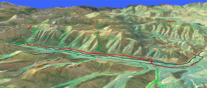
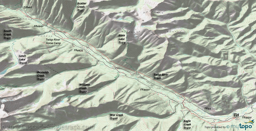
Twisp River Tr440
Twitter Search
#twisprivertrail

Overall: 7
Aerobic: 5
Technical: 4
Steepness: 5
Flow: 6
Singletrack: 100%
The Twisp Washington Twisp River Trail is an easy riverside ride, suitable for the family or as a last-day ride if staying in the area. The trail is long enough to be challenging for beginner and intermediate riders.
Type
OAB
Length
Avg: 27.5mi
Ascent
Easy
Elevation Change
TH:2400'
Avg Ascent:5300'
Ascent Incline
5%
Duration
Avg: 5hr
Weather
Forecast
NOAA
popup
USFS
Trail
Review
Low elevation makes this trail an early season ride, if other trails are still snowed in.
Water crossings at Scatter and Slate creeks may become difficult in the Spring. Some riders choose to start from the War Creek CG, avoiding the 3.8mi FR4420 section. The terrain becomes rocky and technical north of the Poplar Flat CG (10mi), with an option of riding FR4440 to Gilbert, returning on the trail.
The trail is surrounded by wilderness areas, off limits to biking.
A typical riverside ride, Twisp River Tr440 traverses the steep valley hillsides, at a high enough elevation from the valley floor to avoid being washed out by Spring runoff. As a result, Twisp River is rarely seen during this ride, although there are some great views of the snow-capped Chelan Sawtooth Wilderness.
Adventuresome hikers will find many great OAB and loop options at the northern end of the Lake Chelan Sawtooth Wilderness Area.
North Creek Tr413 follows the creek, circumnavigating Gilbert Mountain, passing the (7000') Abernathy Pass Cedar Creek Tr476 intersection at 3.2mi, crossing avalanche paths (most notably at 1.7mi) and sub-alpine forest to North Lake. The route offers good views of Abernathy Ridge and the Sawtooth Range. The 2.1mi North Creek crossing is not bridged and is hazardous during Spring runoff.
Twisp Pass Tr432 has several stream crossings prior to the 2.2mi Copper Pass Tr426 intersection, then crosses 1mi of rocky terrain before passing through subalpine forest and a number of small meadows to Twisp Pass. The trail then continues in the North Cascades National Park, alongside East Fork McAlester Creek to the Firewood CG.
Copper Pass Tr426 follows the North Fork Twisp River to Copper Pass, then descends alongside Copper Creek to meet the Pacific Crest Trail at State Creek. This lightly used trail will require some pathfinding, so a GPS is suggested.
South Creek Tr401 (3400' ascent) includes a number of avalanche paths for the first 4.5mi, passing the Louis Lake Tr428 intersection at 2.1mi. There are half a dozen creek crossings on the increasingly rocky terrain as the trail crosses South Pass, then descends to Rainbow Creek Trail in the North Cascades National Park. The 5000' ascent Louis Lake Tr428 starts by descending to the trail bridge crossing of South Creek, but it is all uphill from there, switchbacking through old-growth Douglas fir, Engleman spruce, and Western White Pine forest, then continuing the ascent high above Louis Creek, through old avalanche paths and subalpine forest to the lake.
McAlester Creek Trail connects South Creek Tr401 to Twisp Pass Tr432, passing through mountain hemlock, subalpine fir, and subalpine larch forest.
While sharing the North Cascades National Park with the black bears and the occasional grizzly bear, be sure to hang food while camping and take the usual precautions to avoid conflicts with the 'locals'.
Directions: Go 18mi west on the Twisp River Road to Slate Creek TH. View Larger Map. No Map?.

OAB Directions
river CG tour
- TH: Climb the 300' hillside traverse from the Twisp River TH, then cross Scaffold Camp creek and FR050 at 1.2mi. Continue descending to a creek and FR070 crossing at 2mi, with a few switchbacks along the way. Cross Eagle creek then FR080 at 2.6mi, with a brief ascent then descent to FR4420 at 3.4mi.
- 3.8mi: Ride FR4430 to FR44, then traverse the hillside, crossing FR163 and FR165. Cross a small creek at 4.4mi and 5.3mi, then cross Cook creek at 6.1mi, while continuing to traverse the hillside in a steady ascent. Descend slightly from Cook creek and cross another creek at 6.5mi, then pass the FR217 intersection at 6.9mi.
- 6.9mi: Cross Slate creek then Slate Lake Tr414. Continue moderate ascent, which peaks at 7.9mi near the Mystery CG. After a slight descent, cross a creek at 8.4mi, then ascend the increasingly technical terrain to the 9.5mi Whistling creek crossing.
- 10mi: Pass the Poplar Flat CG and cross two creeks, then cross another creek at 10.5mi. Cross Scatter creek at 11.1mi, then pass the FR395 intersection. Cross a creek then cross the Scatter Creek Tr427 intersection at 11.8mi, with a steep ascent and 4 more creek crossings before crossing FR4440 at 13mi.
- 13.3mi: Pass the FR440 intersection on the right, then cross 3 creeks before reaching FR360 in Gilbert. Return to the TH.
Trail Index
This Ride
Twisp River Trail 440
Area
Angel Staircase Trail 1259.32, Bear Mountain Trail, Blue Buck Trail 421, Cedar Creek Trail 476, Crater Creek Trail 416, Cutthroat Pass Trail 483, Eagle Lake Trail 431, Foggy Dew Trail 417, Foggy Dew Ridge Trail 438, Golden Stairway Trail 354, Lower Eagle Lake Trail 431B, Upper Eagle Lake Trail 431A, Martin Creek Trail 429, Martin Lake Trail 429A, Middle Fork Beaver Creek Trail 406, Lightning Creek Trail 425, Pearrygin Peak Trail 526, Pipestone Canyon Trail, Prince Creek Trail 1255.1, Sun Mountain Trails, West Fork Methow River Trail 480
Wilderness
Bernice Lake Trail 1259.14, Copper Pass Trail 426, Eagle Creek Trail 410, East Fork Buttermilk Trail 420, Fish Creek Trail 1248, Horton Butte Trail 1250.1, Indianhead Basin Trail 1250, Lakeshore Trail 1247, Libby Creek Trail 415, Louis Lake Trail 428, North Creek Trail 413, Oval Creek Trail 410A, Oval Lake Trail 410B, North Fork Prince Creek Trail 1254, Prince Creek Trail 1255, Reynolds Creek Trail 402, Scatter Creek Trail 427, Slate Lake Trail 414, South Creek Trail 401, Summit Trail 1259, Surprise Lake Trail 1249, Twisp Pass Trail 432, War Creek Trail 408, Williams Creek Trail 407, West Fork Buttermilk Trail 411, Wolf Creek Trail 527
Campgrounds
Black Pine Lake Campground, Crater Creek Campground, Cub Lake Campground, Foggy Dew Campground, Mystery Campground, Poplar Flat Campground, Prince Creek Campground, Roads End Campground, South Creek Campground, Surprise Lake Campground, Twisp River Horse Campground, War Creek Campground
Trail Rankings
Ranking consistently applied to all of the listed trails.
- Overall Rating: Ride quality and challenge
- Aerobic: Ascent challenge
- Technical Difficulty: Terrain challenge
- Steepness: Average incline
- Flow: Uninterrupted riding
- Elevation Change: Total elevation gain
- Ride Difficulty: Terrain challenge


