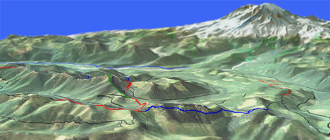
Allen Mountain Tr269

Overall: 7
Aerobic: 7
Technical: 7
Steepness: 7
Flow: 5
Singletrack: 100%
Silver Cr Tr258, Allen Mt Tr269 and a bushwhacking hike-a-bike on Greenwood Lk Tr253 combine into a great ridgeline ride.
Type
OAB
Length
Avg: 19.6mi
Ascent
Mt Goat
Elevation Change
TH:2700'
Avg Ascent:6200'
Ascent Incline
17%
Duration
Avg: 5hr
Weather
Forecast
NOAA
popup
USFS
These trails are not heavily used and can become thick with brush in July and August, so dress accordingly.
Expect swampy conditions after rainfall, as these trails do not dry out rapidly.
Starting near Bear Prairie meadow, Silver Cr Tr258 ascends steadily above the Skate Creek headwaters, through old growth forest to FR8400.
This section is optional, but adds some distance and challenge to the ride.
Allen Mountain Tr269 (aka Skate Mountain Trail) is a lightly used trail which ascends along a ridgeline to the top of Allen Mountain, then crosses an open, subalpine landscape and follows the ridge to the junction with Greenwood Lake Tr253.
Expect rocks and roots, with some narrow singletrack and cliff exposure.
Greenwood Lake Tr253 is a whisper of a trail, rarely used and not maintained.
From the Cougar Gap intersection, the trail summits then descends to Greenwood Lake, then continues on to FR8511.
Bring a GPS and be ready for some outback bushwhacking.
The ride can be accessed from FR8500/FR8511, but those roads are not maintained any better than Greenwood Lake Tr253 so should not be attempted with low clearance vehicles, proven by the undercarriage car parts scattered alongside the road...
Directions: From the Big Creek Campground, go right on FR52 (Skate Creek Road) then go 9.5mi to FR5240. Go right onto FR5240 and go .5mi to FR015, then go right and continue .4mi to the Silver Cr Tr258 TH. View Larger Map. No Map?.

OAB Directions
weed eater
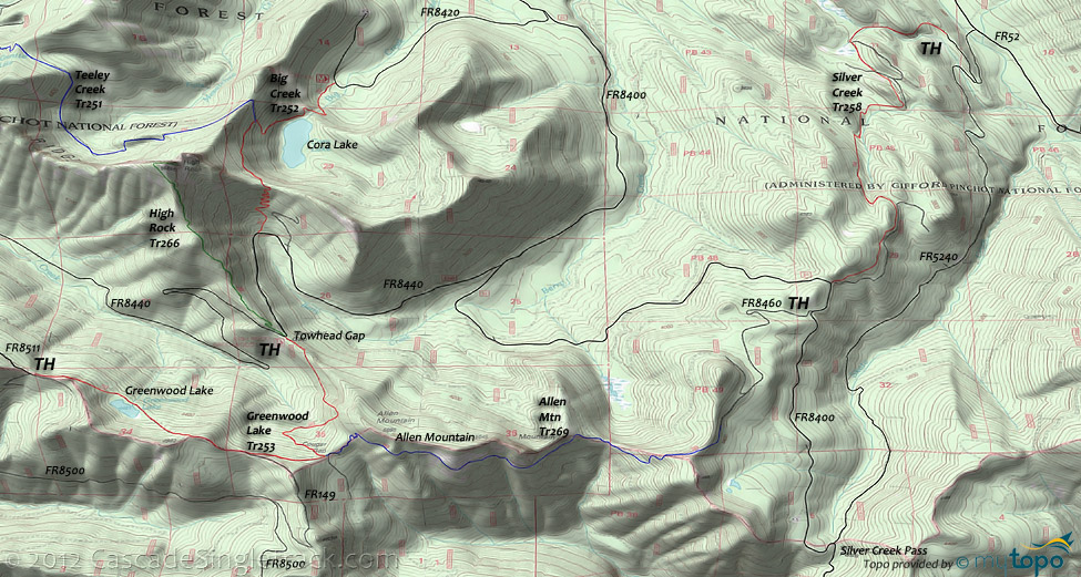
Osborne Mountain Area Topo Map
- TH: The steady climb starts right away, winding up the hillside to FR8400.
- 3.4mi: Go left on FR8400, .3mi to FR8460, then go right and climb 1.6mi to the Allen Mt Tr269 TH.
- 5.2mi: Ride the ridgeline then ascend to Allen Mountain summit.
- 8mi: Go left at the Greenwood Lk Tr253 intersection near Cougar Gap and ride out to Greenwood Lake and ~.5mi beyond. Turn around at the 9.8mi mark and head back to the TH.
Mount Rainier Paradise Park Area Hiking
The southwestern flank of Mount Rainier contains some easily accessible but very challenging day-hikes.
See the Osborne Mtn Tr250 page for the more western Rainier and Glacier View Wilderness hiking trails.
Skyline is the main Paradise Park loop trail, with Deadhorse Creek and Alta Vista providing western extensions and Golden Gate as a mid loop connector.
Tatoosh Traverse provides a more advanced hiking option, with Pinnacle Peak Trail and Bench Lake Trail making a natural loop option.
Families use the Wonderland trail from the Cougar Rock CG to Narada Falls as a popular day-hike, often stopping at Carter Falls.
The Paradise River Camp is 1mi south of Narada Falls. As with all other camping at Mount Rainier, permits are required and expect summertime weekend crowds.
Wonderland Trail is 93mi and circumnavigates Mount Rainier, crossing varied terrain, from lowland forests to high alpine. The northwestern section of Wonderland Trail is covered on the Christoff Tr1171 page.
For much more information, check out the Mount Rainier National Park Trail guide, which includes descriptions of all trails and a variety of maps.
Trail Index
This Ride
Allen Mountain Trail 269, Greenwood Lake Trail 253, Silver Creek Trail 258
Area
Big Creek Trail 252, Bishop Ridge Trail 272, Blue Lake Butte Trail 119, Blue Lake Ridge Trail 271, Boundary Trail 1, Cave Creek Trail 255, Cispus Lookout Trail 127, Dark Meadow Trail 263, Dry Creek Trail 125, Hamilton Buttes Trail 118, High Bridge Trail 293, Jumpoff Trail 271A, Juniper Ridge Trail 261, Klickitat Trail 7, Kraus Ridge Trail 275, Langille Ridge Trail 259, McCoy Peak Trail 259A, Osborne Mtn Trail 250, Pompey Peak Trail 128, Rough Trail 283, Strawberry Mtn Trail 220, Sunrise Trail 262, Teeley Creek Trail 251, Tongue Mountain Trail 294, Valley Trail 270, Wobbly Creek Trail 273, Yellowjacket Trail 1A, Yozoo Tr276
Hiking
High Rock Trail 266
Mount Rainier National Park Paradise Park Hiking
Alta Vista Trail, Avalanche Lilly Trail, Bench Lake Trail, Deadhorse Creek Trail, Fourth Crossing Trail, Golden Gate Trail, High Lakes Trail, Lower Lakes Trail, Narada Falls Trail, Mazama Ridge Trail, Moraine Trail, Pinnacle Peak Trail, Skyline Trail, Tatoosh Traverse, Waterfall Trail, Wonderland Trail
Campgrounds
Big Creek Campground, Cougar Rock Campground, Longmire Campground, Sunshine Point Campground
Trail Rankings
Ranking consistently applied to all of the listed trails.
- Overall Rating: Ride quality and challenge
- Aerobic: Ascent challenge
- Technical Difficulty: Terrain challenge
- Steepness: Average incline
- Flow: Uninterrupted riding
- Elevation Change: Total elevation gain
- Ride Difficulty: Terrain challenge


