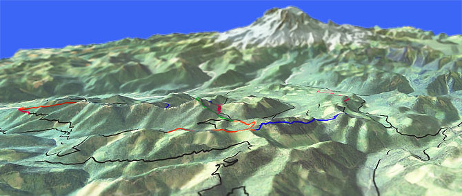
Osborne Mountain Tr250

Overall: 7
Aerobic: 7
Technical: 6
Steepness: 7
Flow: 7
Singletrack: 100%
The Osborne Mtn Tr250 downhill is very popular, but the best XC ride starts from Big Creek Tr252 due to the ease of access and reasonable ascent from the northern Big Creek Tr252 TH. Combine with Teeley Creek Tr251 to create a great OAB ride.
Type
OAB
Length
Avg: 12.6mi
Ascent
Intense
Elevation Change
TH:3400'
Avg Ascent:4700'
Ascent Incline
18%
Duration
Avg: 3hr
Weather
Forecast
NOAA
popup
USFS
Trail
Review
Access from the south is limited by the poor condition of FR8500 and FR8440.
There are several good shuttle opportunities, the best being starting at Big Creek Tr252 and ending at the Big Creek Campground.
FR8410 provides mid-trail access, with the ride in either direction too short to be useful.
Big Creek Tr252 ascends 885' to the intersection with Teeley Creek Tr251, passing Big Creek and Cora Falls before reaching Cora Lake.
Starting from the southern TH on FR8440 involves a moderate switchback climb and so might be preferable to the FR8420 TH.
From the Big Creek Tr252 intersection, Teeley Creek Tr251 is a high alpine ride which traverses the base of Sawtooth Ridge and High Rock, passing Granite and Bertha May Lakes.
The upper section of Osborne Mtn Tr250 is in a saddle, between Osborne Mountain and the Sawtooth Ridge.
The ride passes several timber harvest areas, at the edge of moderately dense forest, with a good view of Mt. Rainier, the Nisqually River Valley and Pothole Lake.
Expect narrow singletrack and cliff exposure. The 2.2mi downhill descends 2200' through 11 very tight switchbacks.
High Rock Tr266 to the High Rock fire lookout is closed to bikes and too steep to climb very easily, but is a worthy cliff exposure hike if camping in the area.
Directions: From the Big Creek Campground, go right on FR52 (Skate Creek Road) then go 2.9mi to FR8400. Go right onto FR8400, then go 4.2mi to FR8420. Go right onto FR8420 then go 1.6mi to the Big Creek Tr252 TH. View Larger Map. No Map?.

OAB Directions
in the saddle
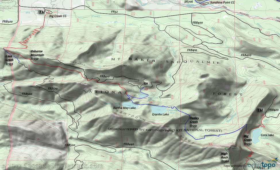
Osborne Mountain Area Topo Map
- TH: From the northern Big Creek Tr252 TH, ascend .9mi past Big Creek Falls and Cora Lake, to the Teeley Creek Tr251 intersection at the base of High Rock Mountain.
- .9mi: Go right onto Teeley Creek Tr251 and ride the base of Sawtooth ridge, over rugged terrain past Granite and Bertha May lakes.
- 4.2mi: Just past Bertha May lake, reach Osborne Mt Tr250 at a T intersection. Continue on Osborne Mt Tr250. Ascend through a dense conifer forest over a sandy trail surface (might have to hike-a-bike some of this), merging with FR8410 at 4.85mi. The trail merges and leaves FR8410 several times before exiting the left side of the road at 5.2mi.
- 6.3mi: Turn around and return to the TH. Beyond this point, Osborne Mtn Tr250 begins the descent to the Big Creek campground.
Mount Rainier and Glacier View Wilderness Hiking
The southwestern flank of Mount Rainier contains some easily accessible but very challenging day-hikes.
See the Allen Mountain Tr269 page for the more family-oriented Paradise Park trails.
Gobblers Knob Trail accesses the Glacier View Wilderness from the Westside Rd, leading to the Gobblers Knob rock outcrop at the north end of Mount Wow ('goat'), near the pristine Lake George. The Lake George section of this hike is easy enough for families with small children. Lake George has permit-campsites, available park-wide from wilderness information centers, ranger stations, and visitor centers.
Westside road is gated at 3mi, just prior to Tahoma Creek, and FR5900 is gated just past the FR5920 intersection, so expect to hike to most of the west side trailheads.
From Longmire, Comet Falls-Van Trump Trail and Rampart Ridge Trail form a natural loop from Christine Falls to Longmire Meadow. The hike to the 320' Comet Falls is popular, often overwhelming the small Comet Falls trailhead, so consider a shuttle or some Plan B hike. Look for marmots and pikas on the rocky slopes. Trail of The Shadows circumnavigates Longmire Meadow is a short hike suitable for families with smaller children.
Eagle Peak Trail is a good alternative to the Comet Falls-Van Trump-Rampart Ridge loop. Park near the Longmire Museum or National Park Inn and walk to the trailhead, 50' beyond the bridge on the left. Ascend 2mi through steep switchbacks and dense, virgin forest to a small stream, then one more mile to the meadow. The final .5mi ascent to the 5700 ft. Eagle Peak-Chutla Peak saddle intersection with Tatoosh Traverse is steep and challenging.
Wonderland Trail is 93mi and circumnavigates Mount Rainier, crossing varied terrain, from lowland forests to high alpine. The northwestern section of Wonderland Trail is covered on the Christoff Tr1171 page.
For much more information, check out the Mount Rainier National Park Trail guide, which includes descriptions of all trails and a variety of maps.
Trail Index
This Ride
Big Creek Trail 252, Cave Creek Trail 255, Osborne Mtn Trail 250, Teeley Creek Trail 251
Area
Allen Mountain Trail 269, Bishop Ridge Trail 272, Blue Lake Butte Trail 119, Blue Lake Ridge Trail 271, Boundary Trail 1, Cispus Lookout Trail 127, Dark Meadow Trail 263, Dry Creek Trail 125, Greenwood Lake Trail 253, Hamilton Buttes Trail 118, High Bridge Trail 293, Jumpoff Trail 271A, Juniper Ridge Trail 261, Klickitat Trail 7, Kraus Ridge Trail 275, Langille Ridge Trail 259, McCoy Peak Trail 259A, Pompey Peak Trail 128, Rough Trail 283, Silver Creek Trail 258, Strawberry Mtn Trail 220, Sunrise Trail 262, Tongue Mountain Trail 294, Valley Trail 270, Wobbly Creek Trail 273, Yellowjacket Trail 1A, Yozoo Tr276
Hiking
High Rock Trail 266
Western Mount Rainier National Park Hiking
Comet Falls-Van Trump Trail, Eagle Peak Trail, Gobblers Knob Trail, Kautz Creek Trail, Mildred Point Trail, Mirror Lakes Trail, North Puyallup Trail, Round Pass Trail, Rampart Ridge Trail, South Puyallup Trail, St Andrews Creek Trail, Tahoma Creek Trail, Trail of The Shadows, Wonderland Trail
Glacier View Wilderness Hiking
Glacier View Trail 267, Lake Christine Trail 249, Peak Two Trail 268, Puyallup Trail 248
Campgrounds
Big Creek Campground, Cougar Rock Campground, Longmire Campground, Sunshine Point Campground
Trail Rankings
Ranking consistently applied to all of the listed trails.
- Overall Rating: Ride quality and challenge
- Aerobic: Ascent challenge
- Technical Difficulty: Terrain challenge
- Steepness: Average incline
- Flow: Uninterrupted riding
- Elevation Change: Total elevation gain
- Ride Difficulty: Terrain challenge


