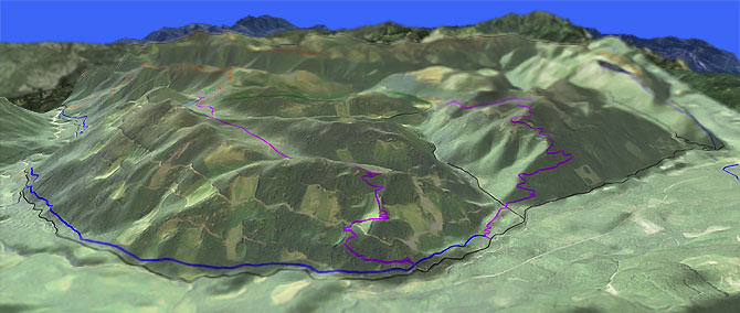
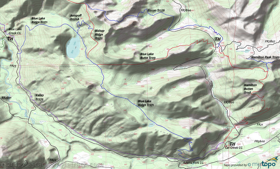
Valley: Hamilton Buttes Tr118

Overall: 6
Aerobic: 6
Technical: 5
Steepness: 6
Flow: 7
Singletrack: 100%
Valley Tr270 is primarily for Orv use, with quad use on the upper 10mi of the trail. This page uses a portion of Valley Tr270 to combine Blue Lake Rdg Tr271, Hamilton Buttes Tr118, Blue Lake Butte Tr119 and Yozoo Tr276 into several good loop options.
Type
Loop
Length
Avg: 17mi
Ascent
Intense
Elevation Change
TH:2700'
Avg Ascent:5400'
Ascent Incline
13%
Duration
Avg: 4hr
Weather
Forecast
NOAA
popup
USFS
The downside of this entire trail system is that it is shared with ORV, and is very popular on the weekends during peak summer months, so wait for the Spring melt then maybe try this one out in late July.
Those seeking an easier ride could either shuttle or just ride the southern portion of Valley Tr270, with only a moderate chance of being run over by an Orv.
This trail system is large enough that the northern rides are covered on the Bishop Tr272 page.
Hamilton Buttes Tr118 ascends 2600' over 4.5mi (13% grade), steadily climbing through old growth and second growth forests before reaching open fields on top of the butte, with views of Mt. Adams and the Cispus River.
The trail then follows the ridge through open meadows, to the intersection with Blue Lake Rdg Tr271 and Yozoo Tr276 near FR7800 and FR7807.
The FR7800 intersection can be used to create a good shuttle option, ending in a downhill ride to the Cat Creek CG TH.
The 17mi ride is Hamilton Buttes Tr118 to Blue Lake Butte Tr119 to Blue Lake Rdg Tr271 to Valley Tr270 and back to the TH.
Subalpine Yozoo Tr276 parallels FR7800 through timber harvest units alongside Timonium Creek before crossing FR78 near Robber Creek, then ascending steadily into the Grouse and Yozoo Creek basins before joining with Bishop Ridge Tr272.
The ride can be extended to 21mi (6300' ascent) by climbing Hamilton Buttes Tr118 then riding Yozoo Tr276 to Bishop Ridge Tr272 and Blue Lake Rdg Tr271 to the TH.
The Wobbly Cr Tr273 5.3mi OAB ascends 1200' from the FR2208 TH, through the semiopen Cispus Burn area to Wobbly Lake.
The trail is less developed beyond the lake, and climbs southwest towards Hamilton Buttes.
Note: FR060 is extremely rough and may be impassible at times.
Directions: Go on SR12 to the center of Randle then go south on combined FR23/FR25. Go 1mi then bear left on FR23 and go 17.5mi to FR21, then go left onto FR21 and continue 6.1mi to the Cat Creek CG. The Hamilton Buttes Tr118 TH is across the street. The FR7800 TH is accessible from FR21 as well. View Larger Map. No Map?.

Loop Directions
big valley
- TH: From the Cat Creek TH, go to intersection with Valley Tr270 and then go right onto Hamilton Buttes Tr118. At .8mi, cross FR78, then continue climbing steadily through a series of switchbacks to the top of the butte.
- 4.5mi: Reach the summit at 2675', then descend 2.2mi to the intersection with Blue Lk Butte Tr119 and Yozoo Tr276.
- 6.7mi: Go left onto Blue Lk Butte Tr119 and climb along the ridgeline, before descending to Blue Lk Rdg Tr271.
- 10.5mi: Go left on Blue Lk Rdg Tr271 and ride along Blue Lake Ridge.
- 14.1mi: Descend 2250' through a series of wild, swooping switchbacks for 2.2mi to Valley Tr270, then go left back to TH.
Klickitat Loop and Goat Rocks Wilderness Hiking: Just north of High Lakes Tr116 and east of Klickitat Tr7 are some trail segments which are popular with Walupt Horse Camp equestrians (constructed and are maintained by members of Backcountry Horsemen of Washington) but also open to biking. To prevent user conflicts and 'mud', avoid Klickitat Loop Tr7A on summer weekends and after rainfall.
Snowgrass Tr96 ascends through conifers until crossing Goat Creek, then switchbacks through talus and timber to Pacific Crest Tr2000-H at Snowgrass Flat.
The easily accessible and popular Walupt Lake Tr101 starts at the Walupt Lake CG and follows the lakeshore to Walupt Creek, then ascends into an open alpine area before turning southeast, ending at Pacific Crest Tr2000-H.
Trail Index
This Ride
Bishop Ridge Trail 272, Blue Lake Butte Trail 119, Blue Lake Ridge Trail 271, Hamilton Buttes Trail 118, Valley Trail 270
Area
Boundary Trail 1, Cispus Lookout Trail 127, Dark Meadow Trail 263, Dry Creek Trail 125, East Canyon Ridge Trail 265, Green Mtn Trail 110, High Bridge Trail 293, High Lakes Trail 116, Jumpoff Trail 271A, Juniper Ridge Trail 261, Keenes Trail 120, Klickitat Loop Tr7A, Klickitat Trail 7, Pompey Peak Trail 128, Spring Creek Trail 115, Tongue Mtn Trail 294, Wobbly Creek Trail 273, Yozoo Tr276
Goat Rocks Wilderness Hiking
Coleman Weedpatch Trail 121, Nannie Ridge Trail 98, Pacific Crest Trail 2000-H, Snowgrass Trail 96, Walupt Lake Trail 101
XC Ski
Campgrounds
Adams Fork Campground, Blue Lake Creek Campground, Cat Creek Campground, Chain of Lakes Campground, Horseshoe Lake Campground, Olallie Lake Campground, North Fork Cispus Campground, North Fork Group Campground, Spring Creek Campground, Takhlakh Lake Campground, Walupt Lake Campground
Trail Rankings
Ranking consistently applied to all of the listed trails.
- Overall Rating: Ride quality and challenge
- Aerobic: Ascent challenge
- Technical Difficulty: Terrain challenge
- Steepness: Average incline
- Flow: Uninterrupted riding
- Elevation Change: Total elevation gain
- Ride Difficulty: Terrain challenge


