High Lakes Tr116

Overall: 6
Aerobic: 5
Technical: 4
Steepness: 5
Flow: 7
Singletrack: 100%
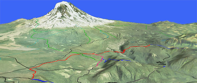
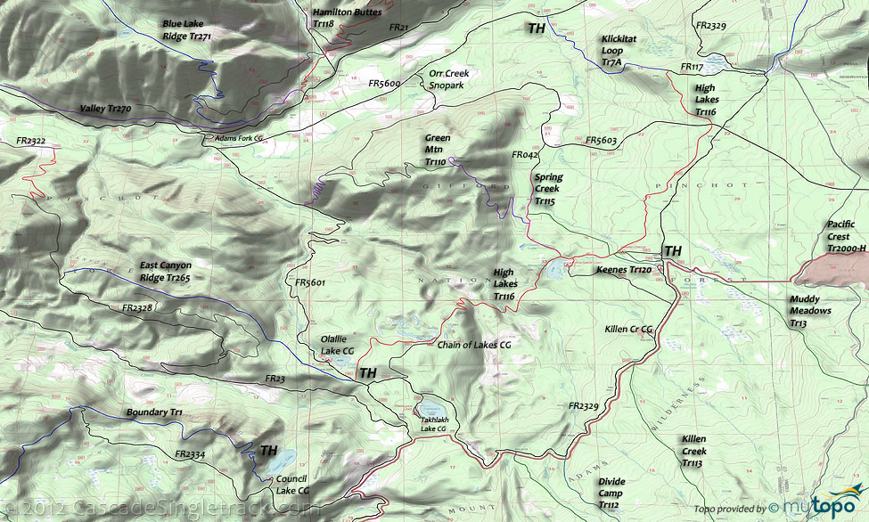
On the north slopes of Mount Adams, High Lakes Tr116 is a trail system with many spur trails, but no really good loop opportunities.
Type
OAB
Length
Avg: 16.6mi
Ascent
Moderate
Elevation Change
TH:4300'
Avg Ascent:2700'
Ascent Incline
14%
Duration
Avg: 3hr
Weather
Forecast
NOAA
popup
USFS
The terrain is moderate enough for XC Skiing (from nearby Orr Creek Snopark) and the trail is shared with equestrians, limiting its utility on the weekends during the summer.
At 4300', expect the riding season to be limited to mid-July through September. Check conditions: At time the extensive area ORV use may render the trail useless to biking.
The trail stats are based on a High Lakes Tr116 OAB ride, starting from FR5601.
The main TH is at the Chain of Lakes Campground.
This conifer forest ride passes by Chain of Lakes, then after passing Horseshoe Lake, enters an open forest with views of Mount Adams.
Keenes Tr120 and Spring Cr Tr115 can be combined to create a lollipop or CW detour from High Lakes Tr116.
Ding: Keenes Tr120 is named for the nearby Keenes Horse Camp and so is not suitable for riding on summer weekends.
Expect a lot of equestrian traffic near the horse camp.
Green Mt Tr110 is suitable for a shuttle ride, between FR5603 and FR5601. This 5mi ride (1500' ascent) ends in a steep set of switchbacks to FR5601.
The southern sections of Klickitat Loop Tr7A are at the northern edge of the High Lakes trail system, and could be explored. See the Valley Tr270 for a Klickitat Loop Tr7A map, which includes the Walupt Lake Goat Rocks wilderness area hiking trails.
The Walupt Horse Camp helps ensure the Klickitat Loop Tr7A gets steady equestrian use in the summer, so avoid after rainfall or on high summer weekends.
East Canyon Rdg Tr265 is a popular 6.7mi OAB ride (1500' climbing), starting from the FR5601 High Lakes Tr116 TH near Olallie Lake and turning around just prior to the final descent to FR2328, offering views of the Goat Rocks, Rainier, Tongue Mountain and Juniper Ridge.
Boundary Tr1 terminates at Council Lake, with nearby connections to Quartz Cr Tr5, Juniper Rdg Tr261 and Langille Rdg Tr259.
The ride starts at Council Lake, ascends past Council Bluffs and Table Mountain, then passes the Quartz Creek Tr5 intersection at Summit Prairie before reaching Juniper Ridge Tr261 at Dark Meadow.
Boundary Tr1 can be combined with Dark Meadow Tr263 into a 14mi shuttle ride, with 3100' ascent although the Council Bluff climb can be avoided by starting the ride from FR2334.
Directions: Depends on the ride, but go on SR12 to the center of Randle then go south on combined FR23/FR25. Go 1mi then bear left on FR23 and go 17.5mi to FR21, then go left onto FR21 and continue 4.6mi to FR5601. Go 5.6mi on FR5601 to the High Lakes TH, or go on to the Chain of Lakes CG. View Larger Map. No Map?.

OAB Directions
descriptive
- TH: Ride out to Chain of Lakes then descend 900' over 1.5mi to Adams Creek. This is the steepest section of this ride.
- 2.9mi: Ascend from Adams Creek to Horseshoe Lake, climbing 490' over 1.5mi. Pass the Spring Cr Tr115 TH at 4.2mi, the Keenes Tr120 at 4.8mi and Keenes Connector Tr120A at 4.9mi. Go left on Keenes Tr120, then left on Spring Cr Tr115 to create a CW lollipop ride.
- 7.5mi: After riding across relatively flat terrain, cross FR5603 and continue to the intersection with Klickitat Loop Tr7A and FR117.
- 8.3mi: At the FR117 intersection, turn around for the return ride to the TH, or go right on FR117 to FR2329, then go right to another section of Klickitat Loop Tr7A and ride to the Goat Rocks Wilderness boundary. Another section of Klickitat Loop Tr7A can be found by going left at FR117, but that trail descends sharply to FR5600 and so is not suitable for a High Lakes Tr116 OAB ride.
Mount Adams Wilderness hiking: Muddy Meadows Tr13 ascends to the northern flank of Mount Adams through timber and small meadows, crossing PCT at 2.7mi. The meadow area was used by Native Americans as a summer berry camp. In the 1800s, many berry camps were located on the north and northwest sides of Mount Adams, with berry-drying trenches in the area. The trail terminates at Highline Tr114, which circumnavigates the northern flank of Mount Adams. To the east, Highline Tr114 crosses glacial meltwater streams that form two branches of the Muddy Fork, which can be hazardous during Spring runoff. The trail is restricted to permit-use as it continues into the Yakima Indian Reservation.
Killen Creek Tr113 was originally a Native American trail used to access berry-picking areas, and leads to High Camp Tr10, which is the access trail to ascend the Mount Adams North Cleaver Route. There is a historical cabin site 2mi from the Killen Creek Tr113 TH, which should not be disturbed.
Not shown on the Area Map, the trails south of Boundary Tr1 are covered on the Quartz Creek Tr5 page.
Trail Index
This Ride
East Canyon Ridge Trail 265, Green Mtn Trail 110, High Lakes Trail 116, Keenes Trail 120, Spring Creek Trail 115
Area
Bishop Ridge Trail 272, Blue Lake Butte Trail 119, Blue Lake Ridge Trail 271, Boundary Trail 1, Cispus Lookout Trail 127, Dark Meadow Trail 263, Dry Creek Trail 125, Hamilton Buttes Trail 118, High Bridge Trail 293, Jumpoff Trail 271A, Juniper Ridge Trail 261, Klickitat Loop Tr7A, Klickitat Trail 7, Pompey Peak Trail 128, Tongue Mtn Trail 294, Valley Trail 270, Wobbly Creek Trail 273, Yozoo Tr276
Mount Adams Wilderness Hiking
Divide Camp Trail 112, High Camp Trail 10, Highline Trail 114, Killen Creek Trail 113, Muddy Meadows Trail 13, Pacific Crest Trail 2000-H, Riley Camp Trail 64, Table Mountain Trail 18
XC Ski
Orr Creek Snopark
Campgrounds
Adams Fork Campground, Blue Lake Creek Campground, Cat Creek Campground, Chain of Lakes Campground, Council Lake Campground, Horseshoe Lake Campground, Keenes Horse Camp, Killen Creek Campground, Olallie Lake Campground, North Fork Cispus Campground, North Fork Group Campground, Spring Creek Campground, Takhlakh Lake Campground, Twin Falls Campground, Walupt Lake Campground
Trail Rankings
Ranking consistently applied to all of the listed trails.
- Overall Rating: Ride quality and challenge
- Aerobic: Ascent challenge
- Technical Difficulty: Terrain challenge
- Steepness: Average incline
- Flow: Uninterrupted riding
- Elevation Change: Total elevation gain
- Ride Difficulty: Terrain challenge


