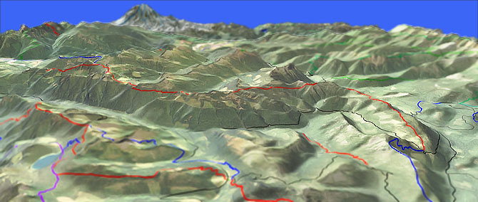
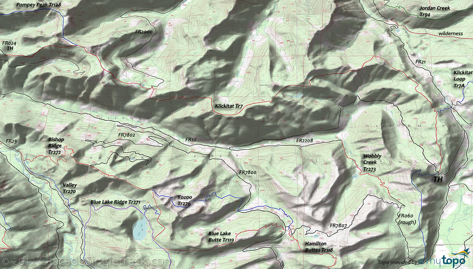
Klickitat Tr7

Overall: 9
Aerobic: 7
Technical: 6
Steepness: 7
Flow: 7
Singletrack: 100%
Klickitat Tr7 is one of the major Cascade ridgeline trails, with three distinct sections between Kilborn Creek and Elk Peak.
Type
OAB
Length
Avg: 18.7mi
Ascent
Intense
Elevation Change
TH:4400'
Avg Ascent:5400'
Ascent Incline
12%
Duration
Avg: 5hr
Weather
Forecast
NOAA
popup
USFS
origins
Klickitat Tr7 and Pompey Pk Tr128 largely follow the Indian trail which extended from Siler Creek, over Lone Tree Mountain, around Pompey Peak and Horseshoe Point, then dropped to Hugo Lake and eventually crossed the Cascades at Cispus Pass.
Pompey Peak was named for a pack mule belonging to A.W. Joerk in the 1890s. A fire lookout was built on the summit of Pompey Peak in 1934, later abandoned and destroyed.
Indians peeled cedar trees (some of these trailside trees still exist) to make folded bark baskets for collecting huckleberries.
Castle Butte and the other high peaks along this trail were carved by glaciers.
St. Michaels Lake and St. John Lake are in cirque basins also carved by glaciers.
Cispus Lookout Tr127 goes to the former Cispus Point fire lookout, with views of the North Cispus River and Smith Creek Basin.
Most of nearby Klickitat Loop Tr7A are popular with equestrians and not well suited for biking.
Wobbly creek and lake are named after International Workers of the World (Wobblies) firefighters, who dug fireline during the 1918 fire.
The trail is easy to shuttle, using FR22 and FR55. The eastern ascent is not as steep as the western ascent, making it the preferred starting TH.
High elevation makes this a late summer ride, with snow patches through July.
The bowl shaped section from just beyond Horseshoe Point to Cispus Summit creates some challenges for anyone wanting to ride the entire trail, and makes these two landmarks good turn around points for those not seeking the full 32mi Klickitat Tr7 OAB ride.
There are two trailheads on the eastern end, with the FR21 Klickitat Loop Tr7A TH as an option for extending the ride into something even more epic than usual.
Otherwise, start from the Klickitat Tr7 FR22 TH and merely have an epic ride.
The western TH is off of FR55, on FR5508.024. FR20 is really FR2000, a largely unmaintained and at times very rough road which runs up the Smith Creek valley, shown more as a warning than a suggestion, and is the least useful TH.
The first 3mi of Pompey Pk Tr128 ascends 4100', a virtually unclimbable 23% grade.
The remaining 3mi, from Pompey Peak past Twin Sisters over an open subalpine ridge to Klickitat Tr7 is relatively flat and so makes a good spur addition to Klickitat Tr7, creating a 34mi (9100' ascent) epic OAB ride.
Most of the ascent is due to the undulating ridgeline terrain.
Western TH: combining the upper 3mi of Pompey Pk Tr128 with a Klickitat Tr7 ride to Cispus Point creates an 11.7mi (3200' ascent) OAB
The first 1.6mi from FR024 gains 1250' (15% grade).
From the eastern TH, riding out to Horseshoe Point creates a 18.7mi OAB ride with 5400' elevation gain and a very reasonable ride profile, so this is the recommended route for those not shuttling or seeking a longer ride.
The initial 1.1mi climb gains 722' (a 12% grade), an easier ascent than the 15% western approach.
Nearby Riverview Tr162 is open to biking, for those staying at the La Wis Wis CG.
Not on the map, but just north of Rimrock Lake is Russell Ridge Tr1111, which is open to biking.
XC Skiing: The White Pass ski area has some trails and west of Rimrock Lake, FR1207 is used for nordic activities as Clear Lake X-C Ski Tr1125.
Directions: See Map. Note: FR22 TH has limited parking. View Larger Map. No Map?.

OAB Directions
wobbly legs
- TH: Climb the first mile, then begin a series of 100'-200' elevation changes that define this ride. Pass Klickitat Loop Tr7A at 2mi.
- 4.5mi: At Mission Mountain, begin .7mi, 600' Sanctuary Arch ascent, followed by a fast 760' descent.
- 6.4mi: Pass St John Lake at the midpoint of a 1mi climb.
- 9.4mi: The ridgeline extends .6mi past Horseshoe Point (the turnaround point), or continue on to Jackpot Lake, Cispus Point and then to Pompey Peak on Pompey Pk Tr128. At some point, turn around and head back to the TH.
Hiking: The unmaintained South Point Lookout Tr123 ascends 3000' in 3.25mi, to an old open burn area at the former South Point lookout site.
Tatoosh Trail 161 is just north of US12 and a popular Tatoosh Ridge hike, between FR5290 and FR5270, with some cliff exposure along the way.
Goat Rocks Hiking: Centered on the McCall Glacier and extending north to US12 and the William O Douglas wilderness, this easily accessible area offers many trailheads and campgrounds along FR21, US12 and Rimrock Lake.
Lily Basin Tr86 climbs a timbered, rugged ridgeline for 4mi to the west face of Johnson Peak, merging with the alpine Snowgrass Tr96 before reaching Pacific Crest Trail 2000-H at Snowgrass Flat (a 10 acre subalpine meadow in a bowl near the headwaters of Snowgrass Creek). Expect the upper sections of this hike to have snow cover until August. Snowgrass Tr96 switchbacks through talus and timber, part of the Klickitat Trail system used by Native Americans traveling over Cispus Pass to the Klickitat River drainage.
Clear Fork Tr61 passes Lily Lake then ascends the Clear Fork of the Cowlitz River, climbing steeply into a forested landscape to Pacific Crest Trail 2000-H at Tieton Pass. Likewise, Upper Lake Creek Tr81 ascends from Packwood lake to the Packwood Saddle, merging with Coyote Tr79. Packwood Lake Tr78 provides access to both of these trails, creating a good day hike loop option. The 452 acre Packwood Lake was used by the Taidnapam people as a fishing and camping site, formed when soil and rock slid off Snyder Mountain 1,200 years ago.
William O Douglas wilderness: North of US12 is a patchwork of easily accessible trails, which extend up to SR410. Tumac Mountain is the central feature, with many loop options from the east or south. Pacific Crest Tr2000-I starts at US12, near the Mount Rainier - Goat Rocks Observation Site, and is the connector trail for this area.
Kincaid Tr42 reaches the top of the ridge near Log Springs, crosses the summit burn, then follows the semiopen ridge. Offering excellent views of Rainier, the trail descends to Jug Lake Tr43 just east of Kincaid Lake. In the 1920s and 1930s the trail was used by sheepherders to reach their camps.
Cowlitz Tr44 winds through dense forest into subalpine terrain, crossing small streams and passing by lakes and small potholes, including Penoyer Lake. A main Native American route across the Cascades, Cowlitz Tr44 is part of the prehistoric Yakama Cowlitz Trail, which linked people from the Cowlitz Valley with people from the Yakima River drainage.
From Rimrock Lake FR1200, FR1207 provides access to Tieton Meadows Tr1128 and Bear Creek Mountain Tr1130. North Fork Tieton Tr1118 and Hidden Springs Tr1117 can be combined with Pacific Crest Trail 2000-H into a relatively short day hike.
Trail Index
This Ride
Cispus Lookout Trail 127, Klickitat Trail 7, Pompey Peak Trail 128
Area
Bishop Ridge Trail 272, Blue Lake Butte Trail 119, Blue Lake Ridge Trail 271, Dark Meadow Trail 263, Dry Creek Trail 125, Green Mtn Trail 110, Hamilton Buttes Trail 118, High Bridge Trail 293, High Lakes Trail 116, Jumpoff Trail 271A, Juniper Ridge Trail 261, Klickitat Loop Tr7A, Tongue Mtn Trail 294, Valley Trail 270, Wobbly Creek Trail 273, Yozoo Tr276
Goat Rocks Hiking
Angry Mountain Trail 90, Backbone Lake Trail 164, Bear Creek Mountain Trail 1130, Bluff Lake Trail 65, Clear Fork Trail 61, Clear Lost Trail 76, Cortright Creek Trail 57, Cowlitz Trail 44, Coyote Trail 79, Cramer Lake Trail 1106, Crossover Trail 41, Dark Meadows Trail 1107, Dumbbell Trail 1156, Glacier Lake Trail 89, Goat Ridge Trail 95, Hidden Springs Trail 1117, Indian Creek Trail 1105, Jordan Creek Trail 94, Judkin Trail 47, Jug Lake Trail 43, Kincaid Trail 42, Lily Basin Trail 86, Mcallister Trail 1109, North Fork Tieton Trail 1118, Pacific Crest Trail 2000-H, Packwood Lake Trail 78, Pipeline Road Trail 74, Pothole Trail 45, Riverview Trail 162, Round Mountain Trail 1144, Sandlake Trail 60, Sand Ridge Trail 1104, Shellrock Lake Trail 1142, Snowgrass Trail 96, South Point Lookout Trail 123, Spiral Butte Trail 1108, Tatoosh Trail 161, Tieton Meadows Trail 1128, Three Peaks Trail 69, Tumac Trail 944, Upper Lake Creek Trail 81
XC Ski
Clear Lake X-C Ski Trail 1125, White Pass X-C Ski Trails
Campgrounds
Dog Lake Campground, La Wis Wis Campground, North Fork Cispus Campground, North Fork Group Campground, Ohanapecosh Campground, Soda Springs Campground, Walupt Lake Campground, White Pass Campground
Trail Rankings
Ranking consistently applied to all of the listed trails.
- Overall Rating: Ride quality and challenge
- Aerobic: Ascent challenge
- Technical Difficulty: Terrain challenge
- Steepness: Average incline
- Flow: Uninterrupted riding
- Elevation Change: Total elevation gain
- Ride Difficulty: Terrain challenge


