Juniper Ridge Tr261

Overall: 8
Aerobic: 9
Technical: 7
Steepness: 9
Flow: 4
Singletrack: 100%
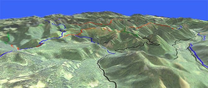
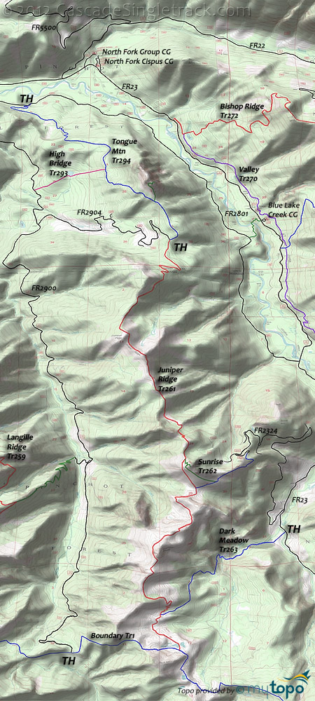
Between Tongue Mt and Dark Mt lie three peaks: Juniper, Sunrise and Jumbo. Between these three peaks are 800' troughs, creating 10% grade climbs, making the southern half of Juniper Rdg Tr261 very challenging (in either direction).
Type
OAB
Length
Avg: 22mi
Ascent
Mt Goat
Elevation Change
TH:2500'
Avg Ascent:7200'
Ascent Incline
12%
Duration
Avg: 5hr
Weather
Forecast
NOAA
popup
USFS
Tongue Mountain was a mountain goat hunting site for Taidnapam Indians.
Juniper Rdg Tr261 was used by sheepherders in the early 1900s and still makes riders sheepish.
There will be no doubt some riding has happened after tackling this one.
There are no good loop options for Juniper Rdg Tr261, although there are several good shuttle options.
There are also at least four great OAB rides, of varying length and difficulty.
To avoid the three peaks, start at FR2801, climb Tongue Mt Tr294 and a portion of Juniper Rdg Tr261 to Juniper Peak, then return to the TH, for a 15.8mi ride and 5200' of climbing.
Most of Tongue Mt Tr294 is a 13% grade, so this route replaces six steep climbs for one really long climb.
Maybe not the best ride for everyone, but a popular downhiller shuttle ride is to use FR2904 and FR2801, south to north on Tongue Mt Tr294.
Since the trail is only 5mi, this would only be about an hour ride.
The hiker-only, steep, unclimbable Tongue Mountain Lookout Trail #294A goes .7mi to the core of an extinct volcano and is worth checking out as a side attraction.
Dark Meadow Tr263 to Juniper Peak is about the same length and difficulty as the Juniper Rdg Tr261 OAB ride.
Dark Meadow Tr263 crosses East Canyon Creek then passes through Douglas fir and western hemlock, before crossing Dark Creek and ascending toward the Dark Meadows area.
Those wishing to only ride the three peaks might try starting at the Sunrise Tr262 TH, which creates an all-pain, no gain ride across just the three peaks.
Failing to see the appeal of a short, endless-climb of a ride merely proves you are not cyborg.
The Boundary Tr1 from Council Lake to Jumbo Peak ride is another popular OAB, covered on the High Lakes Tr116 page.
Directions: Go on SR12 to the center of Randle then go south on combined FR23/FR25. Go left onto FR23 then go 8mi to FR28. Go .8mi on FR28 to FR29 (bear left onto FR29) and go 3.1mi to FR2904. Go 3.9mi to the Tongue Mountain - Juniper Ridge TH. View Larger Map. No Map?.

OAB Directions
three peaks, both directions
- TH: Ascend 1800' over 2.8mi through small conifers to Juniper Ridge. Follow the ridgeline to the base of Sunrise Peak.
- 5.7mi: Pass Sunrise Peak Tr261A, then descend to a meadow and pond. Pass the Sunrise Tr262 intersection then ascend the ridge to Jumbo Peak.
- 8mi: Reach Jumbo Peak then descend sharply to Dark Meadow Tr263 at 10.2mi, through some sharp switchback turns.
- 11.5mi: Reach Dark Meadow lake, at the base of Dark Mountain and the Boundary Tr1 intersection. Head back to TH.
Trail Index
This Ride
Dark Meadow Trail 263, High Bridge Trail 293, Juniper Ridge Trail 261, Sunrise Trail 262, Tongue Mtn Trail 294
Area
Bishop Ridge Trail 272, Blue Lake Butte Trail 119, Blue Lake Ridge Trail 271, Boundary Trail 1, Cispus Lookout Trail 127, Dry Creek Trail 125, East Canyon Ridge Trail 265, Hamilton Buttes Trail 118, Green Mtn Trail 110, High Lakes Trail 116, Jumpoff Trail 271A, Keenes Trail 120, Klickitat Trail 7, Kraus Ridge Trail 275, Langille Ridge Trail 259, McCoy Peak Trail 259A, Pompey Peak Trail 128, Quartz Creek Trail 5, Rough Trail 283, Spring Creek Trail 115, Valley Trail 270, Wobbly Creek Trail 273, Yellowjacket Trail 1A, Yozoo Tr276
Campgrounds
Adams Fork Campground, Blue Lake Creek Campground, Cat Creek Campground, North Fork Cispus Campground, North Fork Group Campground
Trail Rankings
Ranking consistently applied to all of the listed trails.
- Overall Rating: Ride quality and challenge
- Aerobic: Ascent challenge
- Technical Difficulty: Terrain challenge
- Steepness: Average incline
- Flow: Uninterrupted riding
- Elevation Change: Total elevation gain
- Ride Difficulty: Terrain challenge


