Christoff Tr1171

Overall: 6
Aerobic: 7
Technical: 6
Steepness: 7
Flow: 6
Singletrack: 100%
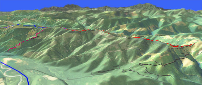
Christoff Tr1171 is the dropout from Divide Tr1172, a 7.6mi subalpine ridgeline ride which can be extended with Grass Mountain Tr1170.
Type
OAB
Length
Avg: 14mi
Ascent
Intense
Elevation Change
TH:4150'
Avg Ascent:5400'
Ascent Incline
20%
Duration
Avg: 4hr
Weather
Forecast
NOAA
popup
USFS
Trail
Review
White River Trails
About 1.5hrs from downtown Seattle, the White River area trails are extremely popular...and happen to also cover some great terrain.
Skookum Flats Tr1194 can be ridden nearly all year, although the glacial water flow of the White River demands some thermal protection most of the year. The higher elevation trails become available when the snow melts (April-July).
The other major rides in the area are Crystal Mt Tr1163, Noble Knob Tr1184, Palisades Tr1198, Ranger Cr Tr1197 and Suntop Tr1183.
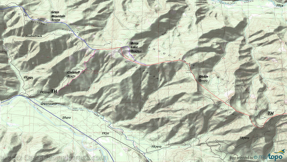
Christoff Tr1171 descends 2500' over 2mi, a 23% grade which would be difficult for most riders to climb, so the suggested ride is a Divide Tr1172 to Mule Springs OAB.
This can be extended by pathfinding further along Grass Mt Tr1170 as far as possible.
Shuttle option: A Divide Tr1172 to Christoff Tr1171 shuttle can create a wild 7.3mi downhill ride.
Divide Tr1172 has several .5mi ascents which are 25% grade, short enough sprints for strong riders to climb.
Grass Mountain Tr1170 traverses the Huckleberry and Grass Mountain ridges.
Logging largely wiped out the trail but hearty pathfinders seek such challenges. The Area map shows most of the doubletrack which crosses the trail, and a GPS is strongly suggested for this ride.
Access to the western TH is shown, using West Twin Creek Road, but most riders would use Grass Mountain Tr1170 to extend a Divide Tr1172 OAB ride.
Directions: NW Forest Pass required right at the TH. SR410 to FR70, then go left onto FR7010, cross the creek, and follow FR7010 and FR7012 to the ridge, then go left onto the trail. View Larger Map. No Map?.

OAB Directions
bare mountain riding
- TH: Go left from the FR7012 intersection, with a .4mi, 25% climb, just to warm things up some.
- 1.6mi: Over a 1mi section, the trail drops 500' off the ridgeline then regains most of the elevation.
- 4mi: Bone Lake Tr1172.1 detour, which loops around the other side of the lake, then climbs 300' to rejoin Divide Tr1172 at the 4.8mi mark.
- 5.4mi: Christoff Tr1171 intersection, for those doing a shuttle ride (or some crazy road climb exercise, but that would be road biking not mtn biking). Continue on Grass Mt Tr1170.
- 6.2mi: Mule Springs. Continue on as far as the trail can be found, then turn around and head back to the TH.
Area Hiking: Kelly Butte Tr1031 is a popular (June-September) hiking trail, easily accessible from FR7030, with a more adventurous ascent to the Kelly Butte Lookout from FR54, passing rock towers and outcroppings along the way.
Frog Mountain Tr1180 is open to biking but at 2.3mi, is far too short to be of use. Carbon Tr1179, Summit Lake Tr1177 and Clearwater Tr1178 used to be open to bikes and was a popular loop, but now these Clearwater Wilderness trail are only available to hiking.
FR7810 provides access to the northern Mount Rainier entrance, with a ranger station near the Ipsut Creek CG. FR7550 leads to a Northern Loop spur, alongside the West Fork White River.
Expect heavy hiker traffic on all the trails nearest the Carbon Glacier road. Venture to the east side of Mount Rainier for more secluded hiking.
Wonderland Trail is 93mi and circumnavigates Mount Rainier, crossing varied terrain, from lowland forests to high alpine.
For much more information, check out the Mount Rainier National Park Trail guide, which includes descriptions of all trails and a variety of maps.
Trail Index
This Ride
Bone Lake Trail 1172.1, Christoff Trail 1171, Divide Trail 1172, Grass Mountain Trail 1170
Area
Buck Creek Trail 1169, Crystal Mountain Trail 1163, Dalles Ridge Trail 1173, Dalles River Trail 1204A, Deep Creek Trail 1196, Doe Falls Trail 1174, Hen Skin Lake Trail 1193, Noble Knob Trail 1184, Palisades Trail 1198, Ranger Creek Trail 1197, Silver Creek Trail 1192, Skookum Flats Trail 1194, Suntop Trail 1183, White River Trail 1199
Christoff Area Hiking
Federation Forest State Park, Kelly Butte Trail 1031, Sawmill Creek Trail 1032
Mount Rainier NP
Green Lake Trail, Northern Loop Trail, Spray-Seattle Park Trail, Tolmie Peak Trail, Wonderland Trail
Clearwater Wilderness
Bearhead Trail 1179.1, Carbon Trail 1179, Clearwater Trail 1178, Frog Mountain Trail 1180, Summit Lake Trail 1177
Trail Rankings
Ranking consistently applied to all of the listed trails.
- Overall Rating: Ride quality and challenge
- Aerobic: Ascent challenge
- Technical Difficulty: Terrain challenge
- Steepness: Average incline
- Flow: Uninterrupted riding
- Elevation Change: Total elevation gain
- Ride Difficulty: Terrain challenge


