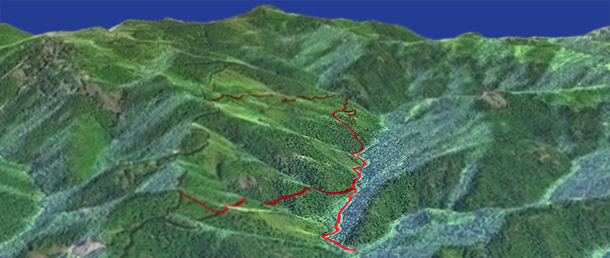
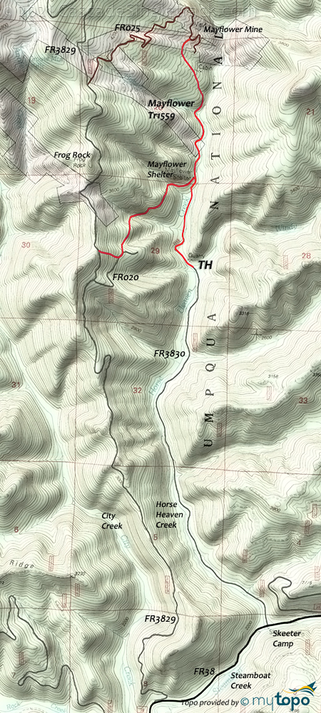
Mayflower Tr1559

Overall: 4
Aerobic: 6
Technical: 5
Steepness: 6
Flow: 4
Singletrack: 50%
South of Oakridge Oregon, the Mayflower Trail is a short ride to the Mayflower mine, linked with some mining roads to create a CCW loop.
Type
Loop
Length
Avg: 6.5mi
Ascent
Moderate
Elevation Change
TH:2450'
Avg Ascent:2350'
Ascent Incline
12%
Duration
Avg: 2hr
Weather
Forecast
NOAA
popup
USFS
Too short to be a destination ride, getting to the TH is also very time consuming, so considered this to be a local trail to use if camping in the area.
Be very careful around the Mayflower mine and other mine sites, as tunnels and paths often lead to steep, deep vertical shafts.
Bohemia National Recreation Tr1407 was created in 1864-65 as a wagon route to the Bohemia Mines, through old-growth forest, rock cliffs and open meadows.
Bohemia Mountain Tr1440 is a steep hiking trail which leads to the rocky summit of Bohemia Mountain, the highest point on the Cottage Grove District.
Area Hiking: Hardscrabble Ridge Tr1408A and Fairview Creek Tr1408 travel through large second growth Douglas fir forest on routes historically used by Bohemia Mountain miners. Fairview Creek offers towering old growth forest, steep rock walls and a cascading stream. The trail used to ascend to Knott Tr1417 but that section is currently not maintained or passable.
Directions: NW Forest Pass required right at the TH. SR138E 23mi to FR38 (Steamboat Creek Rd), for 19mi to the FR3830 (Horse Heaven Rd) TH. View Larger Map. No Map?.

Loop Directions
mine tour
- TH: From the Windy Creek TH, ride alongside Horse Heaven Creek to the Mayflower Mine, passing the Mayflower Shelter and return trail on the left at .7mi. Cross Hobart Creek at 1.2mi, then ascend 600' along the steep hillside terrain to FR025.
- 1.8mi: At the Mayflower Mine, go left onto FR025 and ascend 800' to FR3829 and the ride summit.
- 3.3mi: Go left onto FR3829 and descend alongside the ridgeline to FR020, passing Frog Rock at 4mi.
- 4.7mi: Find the trail on the left side of the road and begin the fast descent to the Mayflower Shelter. FR020 is just beyond this upper trailhead, and crosses the trail so another option if the upper TH is overgrown or otherwise not found. Descend 800' then cross a creek at 5.2mi.
- 5.8mi: Reach the lower trail at the Mayflower Shelter, then go right and return to the TH.
Trail Index
This Ride
Mayflower Trail 1559
Area
Adams Mountain Trail 1419, Bohemia National Recreation Trail 1407, Brice Creek Trail 1403, Crawfish Trail 1421, Knott Trail 1417, Noonday Wagon Road Trail 1405, Upper Trestle Creek Trail 1403D, North Umpqua Trail 1414 Dread and Terror Segment, North Umpqua Trail 1414 Marsters to Toketee Segment, North Umpqua Trail 1414 Panther to Marsters Segment, North Umpqua Trail 1414 Swiftwater to Steamboat Segment
Oakridge Area
Alpine Trail 3450, Aubrey Mountain Trail 3554, Bunch Grass Trail 3559, Cloverpatch Trail 3457, Deception Butte Trail 3466, Eagles Rest Trail 3461, Eugene to Pacific Crest Trail 3559, Eula Ridge Trail 3463, Goodman Creek Trail 3461.1, Hardesty Trail 3469, Hardesty Way Trail 1402, Larison Creek Trail 3646, Lawler Trail 3473, Lone Wolf-Patterson Mountain Trail 3470, Lost Creek Trail 3462, Middle Fork Willamette Trail 3609, Salmon Creek Trail 4233, Sawtooth Trail 1401, South Willamette Trail 3465, Tire Mountain Trail 3485, Winberry Divide Trail 3476, Youngs Rock Trail 3685
Hiking
Bohemia Mountain Trail 1440, Fairview Creek Trail 1408, Hardscrabble Ridge Trail 1408A, Martin-Sharps Tr1416
Campgrounds
Mineral Campground
Trail Rankings
Ranking consistently applied to all of the listed trails.
- Overall Rating: Ride quality and challenge
- Aerobic: Ascent challenge
- Technical Difficulty: Terrain challenge
- Steepness: Average incline
- Flow: Uninterrupted riding
- Elevation Change: Total elevation gain
- Ride Difficulty: Terrain challenge


