
Larch Mountain Tr441
Twitter Search
#LarchMountainTrail

Overall: 4
Aerobic: 6
Technical: 7
Steepness: 7
Flow: 5
Singletrack: 100%
Near Multnomah Falls Oregon, Larch Mountain Tr441 and a non-restricted section of Oneonta Tr424 offer some steep, technical singletrack, close to Portland. Just be sure to wait for dry conditions and be ready for rough terrain.
Type
Loop
Length
Avg: 6.5mi
Ascent
Moderate
Elevation Change
TH:3000'
Avg Ascent:1600'
Ascent Incline
9%
Duration
Avg: 2hr
Weather
Forecast
NOAA
popup
USFS
The Multnomah Falls headwaters originate at Larch Mountain, the source for Multnomah Creek and Oneonta creek.
Too short to be a destination ride, the extinct shield volcano caldera loop offers some steep technical terrain for a short afternoon ride.
Expect the caldera snowpack to last well into June.
This CW loop consists of Larch Mountain Tr441, Multnomah Creek Way Tr444 and Oneonta Tr424.
Those seeking greater climbing challenges might try a CCW loop.
The trail can be pretty loose and rooty, with the occasional stair-step trail surface.
Large rocks and water bars help complete the amusement ride.
The lowest elevation of this loop is at the northern Multnomah Creek Way Tr444 footbridge, so consider the Larch Mountain FR315 TH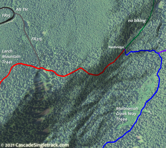
View of Larch Mountain FR315 TH instead of the Larch Mtn parking lot.
Columbia River Gorge National Scenic Area Hiking

Several good day hiking loops or various length and difficulty. The Gorge walls are steep, with FR777 (gated, just past the water tank) providing easier access to the upper terrain.
Tanner Butte Tr401 starts in Douglas-fir and noble and silver fir, then switchbacks to Dublin Lake. Create a loop by returning on Tanner Cutoff Tr448. The Columbia Wilderness portion of the trail is brushy and requires good route-finding skills.
Gorge Tr400 parallels I-84, provind a connector for Oneonta Tr424 and Nesmith Point Tr428.
Munra Point Trail and Wahclella Falls Trail are each .9mi in length, offering short dayhike potential.
2017 Eagle Creek Fire: The middle portion of the Columbia River Gorge trail system was damaged by the fires. See the Mount Hood NF Site for closures.
Directions: I-84 Corbett exit, then follow the Larch Mt. signs. Bear left at the first Y then bear right at intersection just past the Grange Hall, passing a firestation along the way. Ride from the parking lot, or risk parking at the Larch Mountain FR315 TH. View Larger Map. No Map?.

Loop Directions
caldera ride
- TH: From the Larch Mountain FR315 TH, ride .3mi to the Larch Mtn Tr441 intersection, just prior to the end of FR315, and go left. Descend .8mi, then go right onto Multnomah Cr. Way Tr444 and continue to the intersection with Multnomah Spur Tr446, then go right to stay on Multnomah Cr. Way Tr444.
- 1mi: Cross the footbridge then begin a gradual ascent that gets steeper after crossing the first creek. Cross the second creek at 1.8mi then work through several switchbacks over rough terrain. Reach the top of this section at 2mi, then continue climbing for .5mi, working around the base of Sherrard Point.
- 3.5mi: After a mile of relatively flat ridgeline terrain, go right on Oneonta Tr424 and ascend 1mi to FR15 and the Larch Mountain parking area.
- 4.9mi: At the far end of the parking area, go on Larch Mtn Tr441 and reach the ride summit near the camping area, then enjoy the 11% descent to FR315.
- 6.3mi: FR315 intersection. Not enough? Do it again..

Trail Index
This Ride
Larch Mountain Trail 441, Multnomah Creek Way Trail 444, Multnomah Spur Trail 446, Oneonta Trail 424
Area
Alpine Trail 600, Bells Mountain Trail, Cache Meadow Trail 702, Corral Springs Trail 507, Cripple Creek Trail 703, Crosstown Trail 755, Glade Trail 661, Grouse Point Trail 517, Huxley Lake Trail 521, Larch Mountain Trail 441, Oneonta Trail 424, Pioneer Bridal Trail 795, Post Canyon Trails, Sandy Ridge Trails Serene Lake Trail 512, Shellrock Lake Trail 700, Silver Star Trail 180, Still Creek Trail 780, Tarbell Trail
Columbia River Gorge National Scenic Area Hiking
Angels Rest Trail 415, Bell Creek Trail 459, Devils Rest Trail 420C, Franklin Ridge Trail 427, Gorge Trail 400, Horsetail Creek Trail 425, Horsetail Falls Trail 438, Larch Mountain Trail 441, Moffett Creek Trail 430, Munra Point Trail, Nesmith Point Trail 428, Oneonta Trail 424, Return Trail 442, Sherrard Point Trail 443, Tanner Butte Trail 401, Tanner Creek Trail 431, Tanner Cutoff Trail 448, Tanner Springs Trail 401E, Vista Point Trail 419, Wahclella Falls Trail 436, Wahkeena Trail 420, Wauna Viewpoint Trail 402
Campgrounds
Ainsworth State Park Campground, Eagle Creek Campground, Herman Creek Campground, Indian Springs Campground, Rainy Lake Campground, Wahtum Lake Campground, Wyeth Campground
Trail Rankings
Ranking consistently applied to all of the listed trails.
- Overall Rating: Ride quality and challenge
- Aerobic: Ascent challenge
- Technical Difficulty: Terrain challenge
- Steepness: Average incline
- Flow: Uninterrupted riding
- Elevation Change: Total elevation gain
- Ride Difficulty: Terrain challenge
