North Fork Taneum Orv Tr1377
Twitter Search
#TaneumTrails

Overall: 7
Aerobic: 6
Technical: 5
Steepness: 6
Flow: 6
Singletrack: 100%
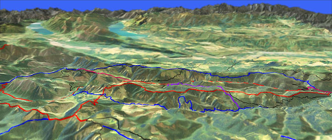
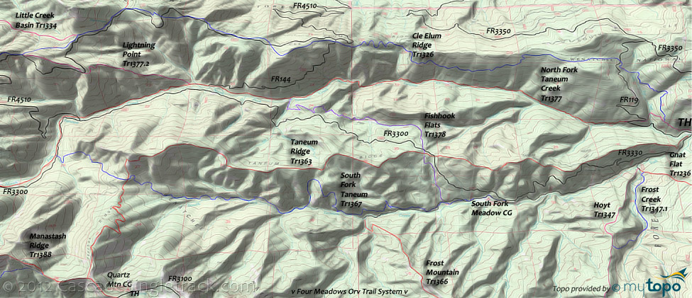
North Fork Taneum Tr1377, Cle Elum Ridge Tr1326, Taneum Ridge Tr1363 and South Fork Taneum Tr1367 are Cle Elum Washington Taneum Canyon trails which ascend to Manastash Ridge Tr1388. Connector trails such as Fishhook Flats Tr1378 and Lightning Point Tr1377.2 combine with forest roads to enable loop rides for intermediate to advanced riders.
Type
Loop
Length
Avg: 20mi
Ascent
Intense
Elevation Change
TH:2900'
Avg Ascent:3500'
Ascent Incline
14%
Duration
Avg: 4hr
Weather
Forecast
NOAA
popup
USFS
Trail
Review
Beginners could try the first 11mi of North Fork Taneum Tr1377, but will likely find the rest of the terrain too technical and steep.
The access trail from the Ice Water campground to the Taneum Junction TH is also suitable for beginners.
Ding: Virtually all of the trails in this area are open to Orv, although many are restricted to motorcycles.
Manastash Ridge Tr1388 forms the western ridgeline boundary of the Taneum trail system.
The area north of Cle Elum Ridge Tr1326 is covered on the North Ridge Tr1321 page, which includes Goat Peak Tr1304 and the hiker-friendly Big Creek Tr1341.
The area south of South Fork Taneum Tr1367 is covered on the Frost Mountain Tr1366 page, which includes a large number of short trails which combine into an endless loop ride. Hoyt Tr1347 also accesses the Four Meadows area.
Fishhook Flats Loop: Covered in this guide, the Taneum Ridge Tr1363 (or FR3300), Fishhook Flats Tr1378, North Fork Taneum Tr1377 13.5mi (3200', 10% ascent) CW loop is very popular and could also be ridden CCW.
North Fork Taneum Tr1377 to Taneum Ridge Tr1363 creates a 20mi (4800' ascent) CCW loop, with moderate climbing leading to a steep Taneum Ridge Tr1363 ridgeline descent.
Directions: NW Forest Pass required right at the TH. West Taneum Road to FR33 then go left on FR3300 and over a bridge when you reach the turnoff for Taneum CG. Go 8.6mi then turn left onto Icewater CG. Park near the entrance or down by Taneum Cr. View Larger Map. No Map?.

Loop Directions
trails in every direction
- TH: From the Taneum Junction TH, bear left onto FR3300, cross the North Fork Taneum Creek then either go right onto Taneum Ridge Tr1363 or ascend the 1000' to the Taneum ridgeline on FR3300. The next Taneum Ridge Tr1363 / FR3300 intersection is at 1.8mi, with the ride summit at 2.8mi.
- 4mi: Cross FR3300 again at 3.9mi, then go right onto Fishhook Flats Tr1378 and zip through some fast meadows riding for 1.4mi, then briefly hike-a-bike through some switchbacks, cresting at 6.3mi. Descend and cross Kid Creek, then descend to North Fork Taneum Tr1377.
- 7.2mi: Go right on North Fork Taneum Tr1377 and descend the gradual terrain to the TH.
- Option: ascend North Fork Taneum Tr1377, possibly returning on South Fork Taneum Tr1367, then FR135 to the TH.
Lookout Mtn Epic
A 29mi (7200' ascent) North Fork Taneum Tr1377 to Cle Elum Ridge Tr1326 CW loop around Lookout Mountain includes some hike-a-bike, pathfinding, and rough, technical terrain.
- TH: Ascend North Fork Taneum Tr1377, which gets progressively more technical past the 6.3mi Fishhook Flats Tr1378 intersection.
- 12.3mi: Pass the Taneum Shelter then climb or hike-a-bike through some steep, wild switchbacks to the Windy Pass intersection.
- 13.3mi: At Windy Pass, go right onto Cle Elum Ridge Tr1326 and ascend to the 13.6mi ride summit, followed by a steep descent along a northern Lookout Mountain ridgeline spur, above the Lookout Creek drainage. The trail winds through a timber harvest at 15.7mi, requiring some pathfinding through the roadside timber harvest to regain the trail.
- 16.1mi: Pass the FR4510 - Lightning Point Tr1377.2 intersection (the trail briefly merges with the road), cross some doubletrack, then pass the 16.9mi Little Creek Basin Tr1334 - FR120 intersection on the left.
- 17.7mi: Pass the Granite Creek Tr1326.1 intersection on the left, then cross FR4510 multiple times over the next 2mi..
- 20.7mi: Cross FR144 then descend through some steep switchbacks, crossing some doubletrack along the way. The trail traverses down then back up the ridge, to the 24.1mi FR111 'Windy Pass Tr1326' sign, then crosses some spur roads.
- 25.4mi: Cross FR119 at 24.4mi, then descend the First Creek drainage, reaching the North Fork Taneum Tr1377 access trail at 27mi. Go right, back to the FR119 TH.
Trail Index
This Ride
Cle Elum Ridge Trail 1326, Fishhook Flats Trail 1378, Lightning Point Trail 1377.2, North Fork Taneum Trail 1377, Taneum Ridge Trail 1363, South Fork Taneum Trail 1367
Area
Campgrounds
Ice Water Campground, Quartz Mountain Campground, South Fork Meadow Campground, Tamarack Spring Campground, Taneum Campground
Trail Rankings
Ranking consistently applied to all of the listed trails.
- Overall Rating: Ride quality and challenge
- Aerobic: Ascent challenge
- Technical Difficulty: Terrain challenge
- Steepness: Average incline
- Flow: Uninterrupted riding
- Elevation Change: Total elevation gain
- Ride Difficulty: Terrain challenge


