Manastash Ridge Tr1388
Twitter Search
#ManastashTrail

Overall: 6
Aerobic: 6
Technical: 6
Steepness: 5
Flow: 7
Singletrack: 100%
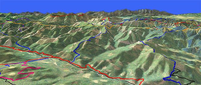
The Ellensburg Washington Manastash Ridge Trail covers rugged terrain which extends along the ridgeline from Quartz Mountain, past Mount Clifty, to Blowout Mountain.
Type
Loop
Length
Avg: 13mi
Ascent
Intense
Elevation Change
TH:6200'
Avg Ascent:4550'
Ascent Incline
7%
Duration
Avg: 3.5hr
Weather
Forecast
NOAA
popup
USFS
Manastash is a nice ridge ride to Blazed Ridge, after which the trail traverses the ridgeline and gets steep enough to force some hike-a-bike.
Ding: All of the trails in this area are open to Orv and easily accessible. Because Manastash Ridge Tr1388 connects so many other trails, expect heavy Orv use on the weekends.
East of the FR3100 Quartz Mountain TH, the trail is mostly doubletrack on FR306 and FR694, favored by Orv users.
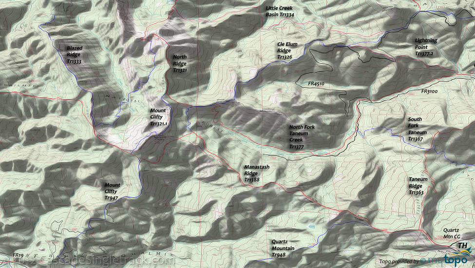
Manastash Ridge Tr1388 forms the upper boundary of the Taneum Rdg Tr1363 trail system and is a ridgeline connector for the Quartz Mtn Tr948 and Mount Clifty Tr947 loop rides.
Manastash Ridge Tr1388 can be combined with Cle Elum Ridge Tr1326, North Ridge Tr1321 and Mount Clifty Tr1321.1 (the Cle Elum RD section of Mount Clifty Tr947) into a 13mi lollipop ride, which makes full use of the ridgeline and avoids any severe elevation changes.
Directions: See Map. NW Forest Pass required right at the TH. Manastash Road becomes FR31. Pass Buck Meadows and follow signs toward Quartz Mt to the trailhead. View Larger Map. No Map?.

Loop Directions
mount clifty loop
- TH: Descend along the ridgeline from the Quartz Mountain TH, from knoll to knoll, passing the Quartz Mountain Tr948 intersection on the left at 1.1mi. The ascents across the ridgeline are to overtake the next knoll and do not involve any extreme elevation changes. Ride around a knoll at 3.4mi, then descend a traverse to the Cle Elum Ridge Tr1326 intersection.
- 4.6mi: Go right onto Cle Elum Ridge Tr1326 and traverse below the ridgeline to the North Ridge Tr1321 intersection.
- 5.3mi: Go left onto North Ridge Tr1321 and ascend a few hundred feet to the ridgeline at 5.9mi.
- 5.8mi: Go left onto Mount Clifty Tr1321.1, complete the ridgeline ascent, then ride along the ridgeline to the Mount Clifty 6.7mi summit. The trail crosses the ridge and loops around the summit, with a brief but steep descent/ascent, then traverses below the ridgeline to the Manastash Ridge Tr1388 intersection.
- 7.4mi: Go left onto Manastash Ridge Tr1388, pass the Mount Clifty Tr947 intersection on the right while descending to the next traverse, followed by a gradual climb back to the previously visited Cle Elum Ridge Tr1326 intersection (having completed a circumnavigation of Mount Clifty) and return to the TH.
Trail Index
This Ride
Manastash Ridge Trail 1388, Mount Clifty Trail 1321.1, Cle Elum Ridge Trail 1326, Greek Creek Basin Trail 1321.2
Area
Orv
Manastash Ridge Trail 4W306
Campgrounds
Crow Creek Campground, Halfway Flat Campground, Kaner Flat Campground, Little Naches Campground, Quartz Mountain Campground, Sawmill Flat Campground
Trail Rankings
Ranking consistently applied to all of the listed trails.
- Overall Rating: Ride quality and challenge
- Aerobic: Ascent challenge
- Technical Difficulty: Terrain challenge
- Steepness: Average incline
- Flow: Uninterrupted riding
- Elevation Change: Total elevation gain
- Ride Difficulty: Terrain challenge


