Quartz Mountain Four Meadows: South Fork Manastash Tr1386
Twitter Search
#ManastashTrail

Overall: 6
Aerobic: 6
Technical: 5
Steepness: 6
Flow: 6
Singletrack: 100%
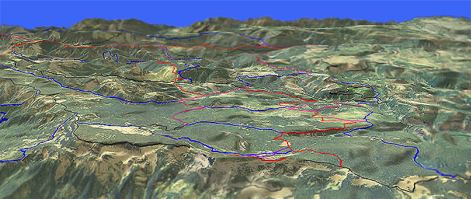
South of Taneum Ridge Tr1363 and east of Manastash Rdg Tr1388, the Ellensburg Washington Hereford, Keenan, Buck and Frost Meadows areas create a flat, wide expanse which is well suited for intermediate riders.
Type
Loop
Length
Avg: 18.5mi
Ascent
Moderate
Elevation Change
TH:4250'
Avg Ascent:3400'
Ascent Incline
10%
Duration
Avg: 4hr
Weather
Forecast
NOAA
popup
USFS
Trail
Review
This area is also sometimes called South Fork Manastash Tr1386.1, one of many, many trails in the area.
As with the rest of the area, all the trails are open to Orv, and with all the camping sites in the area and close proximity to Ellensburg, this is a weekend Orv destination so try to ride these trails during the week is possible and avoid the obvious Orv routes.
As always, trail numbers which include 4W are actually doubletrack or forest roads, such as Shoestring Tr4W308 mostly consisting of FR308.
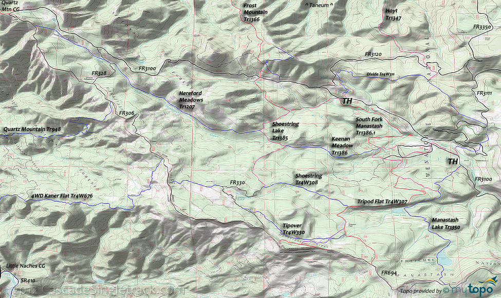
The zig-zagging Shoestring Lake Tr1385 and Tripod Flat Tr4W307 are the main north-south connectors, with the combination of Keenan Meadow Tr1386 and Hereford Meadows Tr1207 covering the width of this trail system and Manastash Lake Tr1350 at the eastern boundary of the trail system.
South Fork Manastash Creek ride: Keenan Meadow Tr1386 and Hereford Meadows Tr1207 as the primary OAB trails, using South Fork Manastash Tr1386.1 and Shoestring Lake Tr1385 on the return to add some terrain variety.
Covered in the guide, the challenging Hoyt Tr1347 to Frost Mountain Tr1366 19.5mi (5300' ascent) CCW Loop starts from Taneum Junction, with an option to ascend (or shuttle ) FR3330 instead of Hoyt Tr1347.
Similar to the Frost Mountain loop, the ever-challenging Quartz Mtn Tr948 is to the west, but should be ridden from the Kaner Flat campground instead of from the ridgeline.
The Quartz Mountain campground is at the highest elevation in this area, so is not a good trailhead location unless shuttling.
FR3111 leads to Tamarack Spring campground, a good mountain bike camping location.
Directions: NW Forest Pass required right at the TH. I-90 exit 109 to Canyon Rd to Umtanum Rd to Manastash Road, which becomes FR31. Park at Buck Meadows FR3104. View Larger Map. No Map?.

Loop Directions
trails in every direction
- TH: From the FR3104 TH, ride 1mi to FR114, then go right and go .5mi through a minor descent to the 4-way intersection with Keenan Meadow Tr1386, South Fork Manastash Tr1386.1 and Bucky TrATV30 and go left onto Keenan Meadow Tr1386.
- 3.2mi: After ascending to Keenan Meadows, go right onto Shoestring Lake Tr1385, cross South Fork Manastash Creek at 3.5mi, then ascend to the Hereford Meadows Tr1207 intersection.
- 3.8mi: Go left onto Hereford Meadows Tr1207, which works it's way down to the creek then runs alongside, with a relatively smooth, gradual ascent from 5.4mi onward. The trail merges with FR328 at 6.8mi, for .1mi, then exits the left side of the road.
- 7.4mi: Cross FR647, then cross FR236, a good turnaround point unless trying to summit Quartz Mountain or otherwise reach FR306.
- 12.8mi: Go left onto Shoestring Lake Tr1385 and ride to FR3100 and the South Fork Manastash Tr1386.1 intersection, passing the Frost Mountain Tr1366 intersection on the left at 13.5mi.
- 14.4mi: Just prior to reaching FR3100, go right onto South Fork Manastash Tr1386.1, descending alongside South Fork Manastash to the sharp switchback at 16mi. Cross the creek, climb to FR114 and return to the TH.
Hoyt, Frost Mt CCW Loop
- TH: Ride FR3300 .5mi to FR135 then left on FR211, then bear right and cross Frost Creek and onto Hoyt Tr1347. An option to hike-a-bike the not-flat Gnat Flat Tr1236 by going left before the creek, with a 1.4mi, 1550' ascent to FR3330. Those seeking a moderate climb should just climb FR3330 from the Ice Water campground intersection.
- 3.4mi: Hike-a-bike or grind through the steep Hoyt Tr1347 ridgeline ascent, cresting at 3.5mi, merging with FR219 to the end of the doubletrack, then crossing FR3120 at 4.8mi. Ride FR632 as a FR3120 shortcut, then bear right at FR3120, as the singletrack resumes.
- 5.3mi: Go right onto Divide Tr4W311 at the FR230 intersection, then noodle across the ridgeline above FR3100, over to some doubletrack intersections near where FR3120 meets FR3100. Some pathfinding required in this area, or just dump out to FR3120 and ride to FR3100.
- 7.8mi: Cross FR3100, onto Shoestring Lake Tr1385, riding along South Fork Manastash Creek.
- 8.8mi: Go right onto Frost Mountain Tr1366. The trail intersects with and then merges with FR124, then crosses FR3100 at 9.9mi (at Frost Meadows). Bear left at the 10.2mi spur trail, then merge with FR118 at 10.5mi, passing the too-steep Frost Mountain summit trail on the right. Go on FR118 for .1mi then go right onto the singletrack. Ride out the ridgeline, with the serious descent starting at 11.9mi.
- 13.4mi: At the FR3322 intersection, go onto South Fork Taneum Tr1367 and descend past the South Fork Meadow campground, to the 16.2mi TH, then ride FR3300 to FR135 and back to the TH.
Trail Index
This Ride
Frost Creek Trail 1347.1, Frost Mountain Trail 1366, Gnat Flat Trail 1236, Hereford Meadows Trail 1207, Hoyt Trail 1347, Keenan Meadow Trail 1386, Rocky Saddle Trail 1384, Shoestring Lake Trail 1385, South Fork Manastash Trail 1386.1
Area
Lost Lake Trail 1350.1, Manastash Lake Trail 1350, Manastash Ridge Trail 1388, Plantation Trail 1350.2, Quartz Mountain Trail 948, Taneum Ridge Trail 1363
Orv
Divide Trail 4W311, Frost Trail 4W310, Manastash Ridge Trail 4W306, Tipover Trail 4W330, Shoestring Trail 4W308, Summit Trail 4W694, Bucky Trail ATV30, Tripod Flat Trail 4W307
Campgrounds
Quartz Mountain Campground, South Fork Meadow Campground
Trail Rankings
Ranking consistently applied to all of the listed trails.
- Overall Rating: Ride quality and challenge
- Aerobic: Ascent challenge
- Technical Difficulty: Terrain challenge
- Steepness: Average incline
- Flow: Uninterrupted riding
- Elevation Change: Total elevation gain
- Ride Difficulty: Terrain challenge


