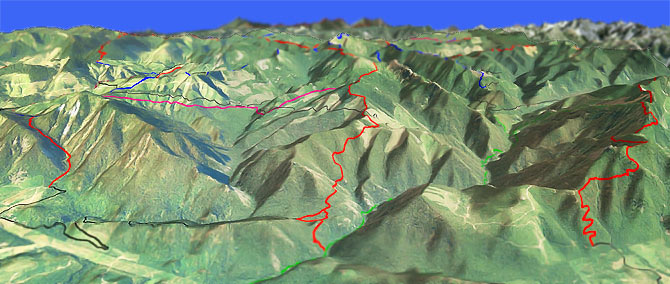
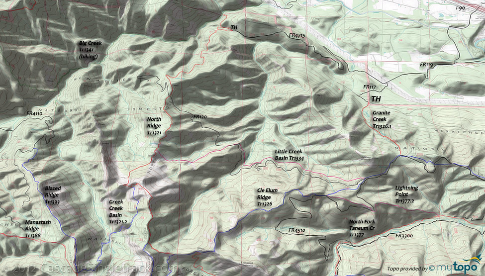
North Ridge Orv Tr1321

Overall: 6
Aerobic: 7
Technical: 6
Steepness: 8
Flow: 5
Singletrack: 75%
North of Taneum Ridge Tr1363 and Manastash Rdg Tr1388, the Cle Elum Washington North Ridge Trail and Goat Peak Tr1304 offer some less-used terrain.
Type
Loop
Length
Avg: 18.5mi
Ascent
Mt Goat
Elevation Change
TH:2850'
Avg Ascent:6100'
Ascent Incline
19%
Duration
Avg: 6hr
Weather
Forecast
NOAA
popup
USFS
The North Ridge and Goat Peak area trails descend to the Yakima River valley, with a typical descent of ~1700' over 1.5mi, limiting the appeal of these trails for most riders.
Those seeking big elevation gains will often have this terrain to themselves. This is an Orv area but these trails are at the edge of that area, so get less motorized use.
The extreme terrain and lack of connecting trails to Goat Peak Tr1304 limits the loop option to FR4110 and makes the initial 2mi ascent mostly hike-a-bike.
Granite Creek Tr1326.1 is no easier, with 2mi of 19% mostly hike-a-bike grade, plus two creek crossings.
If riding North Ridge OAB, the first 3mi (2500' ascent) is a slightly more manageable 16%.
Ding: Combined with the steep terrain, Orv use results in hugely rutted trails (2' ruts in places), which leads to a lot of hike-a-bike.
To connect Granite Creek Tr1326.1 to North Ridge Tr1321, the suggested loop relies on Cle Elum Ridge Tr1326 rather than using Little Creek Basin Tr1334, to avoid traversing the Little Creek Drainage.
The ride could be extended further by looping around Mount Clifty, using Mount Clifty Tr1321.1. A version of that loop is described on the Manastash Ridge Tr1388 page.
The Mt Goat-worthy 13.5mi (5800' ascent) Goat Peak Tr1304 OAB offers a 20% grade 2mi climb, but can be tamed by starting the ride from the FR118 (southern) TH.
FR4110 is washed out at Cabin Creek, just past the FR140 intersection, so to get to the FR118 TH, take FR54 to FR41 to FR4110.
A 39mi (13000' ascent) Mt Goat epic: Ascend North Ridge Tr1321 then ride Manastash Ridge Tr1388 to Blowout Mountain Tr1318, returning on Goat Peak Tr1304.
Some of this terrain is also shown on the Bear Creek Tr943 page.
Shuttle to the North Ridge Tr1321 and Goat Peak Tr1304 and cut the ride down to a mere 31mi.
Tempting, but no: Big Creek Tr1341 and Big Goat Tr1304.1 are only open for hiking.
Directions: I-90 Exit 78 (Golf Course Rd) to the Westside Rd. Go left over the canal, continue .8mi then go right onto Fowler Rd. Go .9mi then bear left at the Y onto FR4317. Go 2.1mi, under the powerlines, then go left onto FR117. Intersection is marked with a Big Creek Trail sign, which is several more miles on FR4317. NW Forest Pass required right at the TH. View Larger Map. No Map?.

Loop Directions
lookout
- TH: From FR117 TH, ascend Granite Creek Tr1326.1, with a creek crossing just past the TH and another at .7mi. The trail is popular with hikers and is closed to Orv, but most riders will be joining the hikers on this section anyway.
- 1.4mi: Just past the Granite Creek headwaters, go right at the Cle Elum Ridge Tr1326 intersection.
- 2.2mi: At the FR120 crossing, pass the Little Creek Basin Tr1334 intersection on the right.
- 3mi: Cross some doubletrack, then pass the FR4510 - Lightning Point Tr1377.2 intersection on the left (the trail briefly merges with the road).
- 4.2mi: The trail winds through a timber harvest, requiring some pathfinding through the roadside timber harvest to regain the trail, followed by a steep ascent along a northern Lookout Mountain ridgeline spur, above the Lookout Creek drainage.
- 5.8mi: After some hike-a-bike switchbacks, reach Windy Pass, and pass the North Fork Taneum Tr1377 intersection on the left.
- 6.1mi: At the fork, go right onto North Ridge Tr1321 and descend to FR4517.
- 13.1mi: Go right onto FR4517 and descend to the FR117 intersection, with a brief climb to the TH.
Ridge to Peak Epic
- TH: Park at Iron Horse state park, then ride alongside the canal on Filbert Rd., to Lund Rd (under the powerlines), to the Big Creek Tr1341 access trail TH.
- 5.6mi: Ride the access trail to North Ridge Tr1321 and traverse the steep Big Creek drainage to the ridgeline. This section of the trail will prove if this ride was a good idea or not.
- 9.3mi: Reach the ridgeline, then cross FR120 at 9.5mi before resuming the North Ridge ascent. Pass the Greek Creek Basin Tr1321.2 intersection on the right at 11.8mi, a trail which traverses the 1000' deep Greek Creek drainage.
- 13.3mi: After reaching a ridgeline peak at 12.3mi, go right onto Mount Clifty Tr1321.1 and ride the rough terrain around the Mount Clifty summit.
- 15mi: Go right onto Manastash Ridge Tr1388, which drops off the ridgeline at the 15.8mi Mount Clifty Tr1321.1 intersection. The descend ends at 17mi, followed by a section of gradually ascending rough trail. The extensive Orv use makes portions of this section hike-a-bike.
- 20.2mi: Pass the FR780 intersection on the left. The trail detours steeply off then back onto the ridgeline, just prior to passing the Cub Creek Tr943A intersection on the left at 22.2mi.
- 23.5mi: At the Bear Creek Tr943 intersection, go right onto Blowout Mountain Tr1318. Snake along the ridgeline to the doubletrack at 26.3mi, then descend the steep access road to FR4110.
- 28.2mi: At FR4110, cross the road and bear to the right onto FR118, climbing back out of the valley. Follow the topo and certainly use a gps, as there are a number of spur trails in the area.
- 31mi: Go on Goat Peak Tr1304 at the end of the doubletrack, passing the Cole Butte summit at 32.6mi and passing the Big Goat Tr1304.1 intersection at 33mi. Drop off the ridgeline in some tight switchbacks to a saddle, then climb past the Goat Peak summit at 34.8mi.
- 36.7mi: After a steep, switchback descent from Goat Peak, reach Cabin Creek Rd and go left, following the Tucker Creek drainage back to the Iron Horse SP TH.
Trail Index
This Ride
Big Creek Trail 1341, Big Goat Trail 1304.1, Blazed Ridge Trail 1333, Blowout Mountain Trail 1318, North Ridge Trail 1321, Cle Elum Ridge Trail 1326, Goat Peak Trail 1304, Granite Creek Trail 1326.1, Little Creek Basin Trail 1334, Greek Creek Basin Trail 1321.2, Mount Clifty Trail 1321.1
Area
Campgrounds
Lake Easton State Park Campground
Trail Rankings
Ranking consistently applied to all of the listed trails.
- Overall Rating: Ride quality and challenge
- Aerobic: Ascent challenge
- Technical Difficulty: Terrain challenge
- Steepness: Average incline
- Flow: Uninterrupted riding
- Elevation Change: Total elevation gain
- Ride Difficulty: Terrain challenge


