Kachess Ridge Tr1315 - Domerie Peak Tr1308
Twitter Search
#KachessRidgeTrail

Overall: 5
Aerobic: 7
Technical: 7
Steepness: 7
Flow: 5
Singletrack: 60%
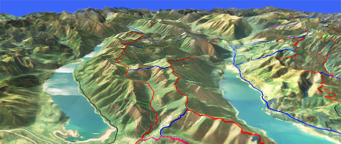
The easily accessible Easton Washington Kachess Ridge Trail ascends Silver Creek valley to Kachess Ridge and Thorp Mountain.
Type
Loop
Length
Avg: 18.5mi
Ascent
Intense
Elevation Change
TH:2300'
Avg Ascent:3700'
Ascent Incline
10%
Duration
Avg: 3hr
Weather
Forecast
NOAA
popup
USFS
Trail
Review
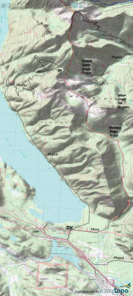
The typical 18.5mi (3700' ascent) CW loop is really a Silver Creek ride and spends no time on Kachess ridge.
The ride starts with 5.8mi of FR4818, a lakeside gravel road, then a 4.7mi grind on FR4824 and FR115 to the French Cabin Basin TH.
The rest of the ride includes many creek crossings and some hike-a-bike.
This is far too much gravel road to be a destination trail, but would be well worth shuttling.
Unfortunately, any attempt to ascend Kachess Ridge Tr1315 from FR203 will face a 1400' climb in the first 1.5mi, and a final ascent to the FR115 TH which is hike-a-bike as well.
The best non-shuttle option is to ride Kachess Ridge Tr1315 9mi OAB, from the northern TH.
The Kachess Ridge Tr1315 OAB ride is covered on the Cooper River Tr1311 page, but is manageable from the FR115 TH as well, with a 600' Thorp Mountain ascent, then relatively flat ridgeline terrain to the northern TH.
The 14mi (5900' ascent) Domerie Peak Tr1308 to Mount Baldy OAB offers something more epic in a ridgeline ride, but the 2.7mi (2000', 19%) North Peak/South Peak ascent is too steep to climb and too long to hike for most riders.
The southern Domerie Peak Tr1308 Mount Baldy approach is even tougher, ascending 2500' in 2.7mi.
Directions: NW Forest Pass required right at the TH. From Kachess Dam Rd, go right on FR4818, then park by the powerlines or on any of the small roads to the right. View Larger Map. No Map?.

Loop Directions
off the ridge
- TH: Ride 5.8mi alongside Kachess Lake on FR4818, then go right onto FR4824, then another right onto FR115 while ascending 4.7mi to Kachess Ridge.
- 10.6mi: At the plateau, go left onto the easily missed Kachess Ridge Tr1315, with an initial descent through the French Cabin Meadows Basin followed by a brief climb to the West Peak saddle at 11.2mi.
- 12.3mi: Pass the hiker-only Silver Creek Tie Tr1308.1 intersection on the left. The trail in this section is technical, with some rocks and roots, plus many creek and Silver Creek crossings to contend with as well.
- 13.6mi: The trail crosses relatively level terrain for 2mi along the base of Thomas Mountain, passing the Kachess Beacon Tr1315.3 intersection on the right at 15.2mi.
- 15.9mi: The trail traverses a steep hillside as it switchbacks for 2mi to the valley floor and FR203.
Trail Index
This Ride
Domerie Peak Trail 1308, Kachess Ridge Trail 1315
Area
Rat Pac Area Trails
Hiking
Domerie Divide Trail 1308.2, Easton Ridge Trail 1212, French Cabin Creek Trail 1305, Kachess Beacon Trail 1315.3, Little Joe Lake Trail 1330.1, Red Mountain Trail 1330, Silver Creek Tie Trail 1308.1, Thorp Creek Trail 1316, Thorp Lake Trail 1316.1
Campgrounds
Lake Easton State Park Campground, Owhi Campground, Red Mountain Campground
Trail Rankings
Ranking consistently applied to all of the listed trails.
- Overall Rating: Ride quality and challenge
- Aerobic: Ascent challenge
- Technical Difficulty: Terrain challenge
- Steepness: Average incline
- Flow: Uninterrupted riding
- Elevation Change: Total elevation gain
- Ride Difficulty: Terrain challenge


