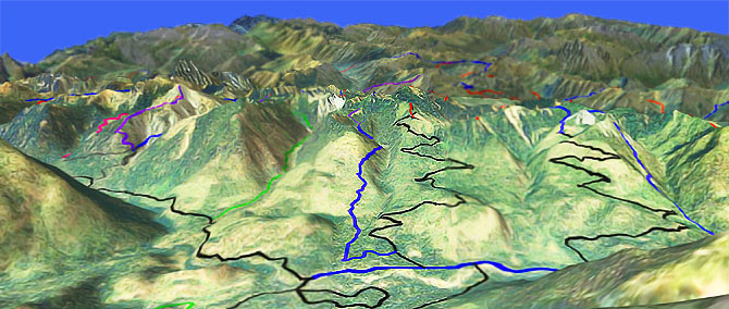
Jolly Mountain Tr1307
Twitter Search
#JollyMountainTrail

Overall: 5
Aerobic: 6
Technical: 5
Steepness: 7
Flow: 5
Singletrack: 55%
The Roslyn Washington Jolly Mountain Trail should be shuttled and is otherwise too short to be a destination ride, but offers some steep, creekside terrain once on the trail.
Type
Loop
Length
Avg: 14mi
Ascent
Intense
Elevation Change
TH:2400'
Avg Ascent:5400'
Ascent Incline
10%
Duration
Avg: 3hr
Weather
Forecast
NOAA
popup
USFS
Trail
Review
The ride can be extended a little by using Yellow Hill Tr1222 to ride to the Jolly Mountain summit and back.
Nearby Paris Creek Tr1393.1 is hiker-only, so Jolly Mountain Spur Tr1307.1 is not a good ride option.
25mi Jolly Epic: Using Jolly Creek Tr1355 to ride to Middle Fork Teanaway Tr1393, returning on Boulder De Roux Tr1392 would create a semi-epic 25mi (7900' ascent) CCW loop ride, with two steep ascents.
Note: The Elsnor Mine Tr1392.8 section is hiker-only, but is a hike-a-bike anyway.
The rest of this route is open to biking and Koppen Mtn Tr1225 could be used to access Boulder De Roux Tr1392.
The Area Topo Map shows all of the trails on this epic route. The Esmeralda Basin Tr1394 page covers some of the same terrain.
Directions: See Map. Go on SR903 to the Salmon La Sac Campground or park alongside FR4315. NW Forest Pass required right at the CG. View Larger Map. No Map?.

Loop Directions
unjolly road grind
- TH: Park at Salmon La Sac campground or near the FR4315 gravel pit, then grind up the switchbacks to Sasse Ridge..
- 6.3mi: Go left onto Sasse Mountain Tr1340 and continue the ascent, with a steep section just prior to the Jolly Mountain Tr1307 intersection.
- 7.4mi: Go left onto Jolly Mountain Tr1307, or continue straight and ascend to the 8.3mi Yellow Hill Tr1222 and complete the ascent at the Jolly Mountain ride summit.
- 8.9mi: From the Jolly Mountain summit, return to Jolly Mountain Tr1307 and go left, then go right at the 10.4mi Sasse Mountain Tr1340 intersection and begin the steep Salmon La Sac creek drainage descent.
- 11.3mi: Pass the Jolly Mountain Spur Tr1307.1 intersection on the right. After some switchbacks to the creek, cross the creek at 11.9mi. The descent intensifies at 12.4mi, with a switchback descent to FR132.
- 14mi: Cross FR132, then go left at the next trail intersection and cross FR132 again, continuing to the FR4315 TH.
Trail Index
This Ride
Jolly Mountain Trail 1307, Sasse Mountain Trail 1340
Area
Boulder De Roux Trail 1392, Camp Creek Trail 1208, Hawkins Mountain Trail 1228, Jolly Creek Trail 1355, Jolly Mountain Spur Trail 1307.1, Middle Fork Teanaway Trail 1393, West Fork Teanaway Tr1353, Yellow Hill Trail 1222
Wilderness
Paris Creek Trail 1393.1, Skookum Basin Trail 1393.2
Campgrounds
Red Mountain Campground, Salmon La Sac Campground,
Trail Rankings
Ranking consistently applied to all of the listed trails.
- Overall Rating: Ride quality and challenge
- Aerobic: Ascent challenge
- Technical Difficulty: Terrain challenge
- Steepness: Average incline
- Flow: Uninterrupted riding
- Elevation Change: Total elevation gain
- Ride Difficulty: Terrain challenge


