
Boulder De Roux Tr1392

Overall: 6
Aerobic: 7
Technical: 7
Steepness: 7
Flow: 5
Singletrack: 100%
A section of the rough and rugged Roslyn Washington Boulder De Roux Trail is included in the Esmeralda Basin Tr1394 and Koppen Mtn Tr1225 loops.
Type
Loop
Length
Avg: 9mi
Ascent
Intense
Elevation Change
TH:3500'
Avg Ascent:3700'
Ascent Incline
11%
Duration
Avg: 2hr
Weather
Forecast
NOAA
popup
USFS
Boulder De Roux Tr1392 traverses Hawkins Mountain, following Big Boulder Creek and De Roux Creek drainages, and is a rocky, rooty trail with plenty of technical challenge.
Boulder De Roux Tr1392 is not long enough to be a destination ride, even when joined with Camp Creek Tr1208 in a 9mi CCW Loop, but for those seeking steep and technically challenging terrain, Boulder De Roux Tr1392 is enough to be interesting and when combined with Esmeralda Basin Tr1394, becomes something near-epic.

A portion of the trail is included in the Esmeralda Basin Tr1394 loop and can be combined with Hawkins Mountain Tr1228 and Esmeralda Basin Tr1394 to create a very challenging 19mi (8100' ascent) triple-peak CCW loop.
Returning on Boulder De Roux Tr1392 is an option to the Hawkins Mountain Tr1228 bombing run, and avoids the Hawkins Mountain summit.
Boulder De Roux Tr1392 is an advanced trail and intermediate riders should try road-accessible Jolly Mountain Tr1307 before attempting the Boulder De Roux Tr1392 ascent.
Another option for intermediate riders would be to climb FR4330 and FR301 (Fortune Creek), then descend Boulder De Roux Tr1392, in a 12.5mi (3200' FR301 ascent) CW loop.

Directions: See Map. SR903 to FR4330 then 5mi to FR138, the Camp Creek TH. The dirt road from FR4330 to Boulder De Roux Tr1392 is not maintained. View Larger Map. No Map?.

Loop Directions
roux de boulders
- TH: Ride from the Camp Creek TH
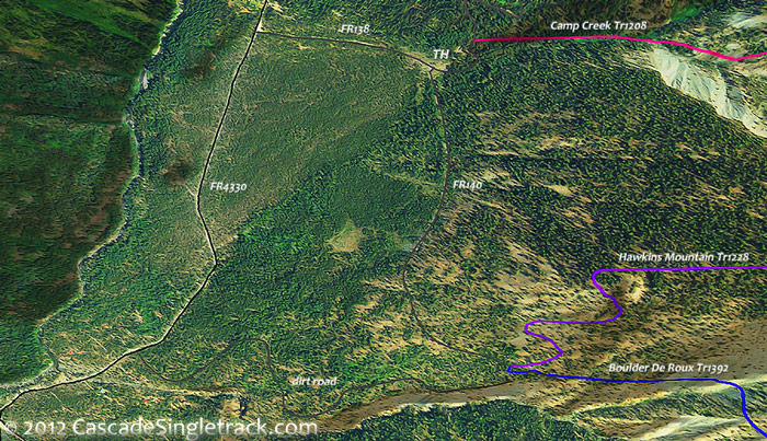
View of the Boulder De Roux,Camp Creek,Hawkins Mountain TH .9mi to Boulder De Roux Tr1392 and begin the rugged ascent, with creek crossings at 1.9mi, 2.3mi, 2.5mi and 3mi. Pass the South Fork Boulder Tr1392.7 intersection on the right at 2.7mi, followed by a creek crossing, then pass the Elsnor Mine Tr1392.8 intersection on the right at 3.2mi. - 4.1mi: Climb out of the Big Boulder Creek drainage at 3.5mi then reach FR301, go left and continue ascending to FR304, which is just past where the Boulder De Roux Tr1392 singletrack resumes (on the right side of the road, towards the De Roux Creek drainage).
- 4.7mi: Go left onto FR304, cross Big Boulder Creek, and ride to the end of the wide dirt road, onto Camp Creek Mine Tr1208.1 at 6.1mi.
- 6.6mi: At the 4-way Hawkins Mountain Summit intersection, which is also the ride summit, go left onto Hawkins Mountain Tr1228 and descend the very steep trail to Camp Creek Tr1208.
- 7mi: Go right onto Camp Creek Tr1208, or continue on Hawkins Mountain Tr1228 if able to handle the extreme terrain which it covers. Cross Camp Creek at 7.5mi, then begin the switchback descent at 8.2mi, to the TH.


Trail Index
This Ride
Boulder De Roux Trail 1392, Hawkins Mountain Trail 1228, Camp Creek Trail 1208, Camp Creek Mine Trail 1208.1
Area
Elsnor Mine Trail 1392.8, Esmeralda Basin Trail 1394, Koppen Mountain Trail 1225, Middle Fork Teanaway Trail 1393, Paris Creek Trail 1393.1, South Esmeralda Peak Trail 1392.2, South Fork Boulder Trail 1392.7
Orv
XC Ski
Campgrounds
De Roux Campground
Trail Rankings
Ranking consistently applied to all of the listed trails.
- Overall Rating: Ride quality and challenge
- Aerobic: Ascent challenge
- Technical Difficulty: Terrain challenge
- Steepness: Average incline
- Flow: Uninterrupted riding
- Elevation Change: Total elevation gain
- Ride Difficulty: Terrain challenge
