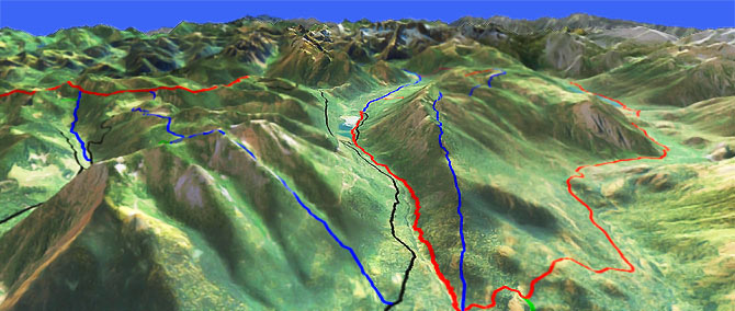
Cooper River Tr1311
Twitter Search
#CooperRiverTrail

Overall: 7
Aerobic: 6
Technical: 6
Steepness: 7
Flow: 6
Singletrack: 100%
Just north of Kachess Lake Washington, Cooper River Tr1311 traverses some rough Polallie Ridge terrain, from the Salmon La Sac campground to Cooper Lake.
Type
OAB
Length
Avg: 10.5mi
Ascent
Moderate
Elevation Change
TH:2450'
Avg Ascent:3500'
Ascent Incline
10%
Duration
Avg: 2hr
Weather
Forecast
NOAA
popup
USFS
Trail
Review
Pete Lake Tr1323 continues 2.4mi, then into the Alpine Lakes Wilderness, past Pete Lake and around Island Mountain, to Delate Meadow.
The first 1.5mi of Cooper River Tr1311 ascends 1000' as it traverses Polallie Ridge, then the trail settles into a steady but rugged ride to the lake.
From Cooper Lake, Pete Lake Tr1323 follows the valley floor, so covers much easier terrain than Cooper River Tr1311.
The wilderness portion of Pete Lake Tr1323 is off limits to biking, but the non-wilderness section is open to biking.
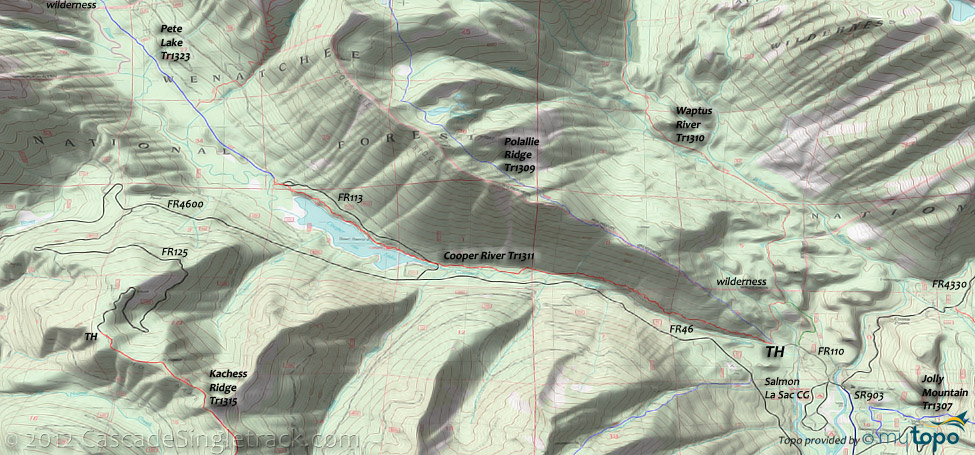
To the south of Cooper Lake, a 9mi (2500') Kachess Ridge Tr1315 OAB to Thorp Mountain offers some moderate, rolling terrain.
Kachess Ridge Tr1315 could be combined with Cooper River Tr1311, using FR4600 and FR125 to connect these two trails, or just ride each OAB and avoid the road climb.
The southern Kachess Lake ride is covered on the Kachess Ridge Tr1315 page.
Red Mountain Tr1330? Closed to bikes and includes a 1.9mi, 3000' (30%) unrideable/life-threatening descent.
The area topo map includes some of the wilderness trails to the north, closed to biking but worth checking out if up for a big hiking excursion.
Epic hike? A 17mi CCW loop of Waptus River Tr1310, Waptus Pass Tr1329 and Polallie Ridge Tr1309 covers some steep and very scenic terrain.
Directions: See Map. SR903 to Salmon La Sac campground, then FR111 to TH. View Larger Map. No Map?.

Loop Directions
rough river ride
- TH: The ride starts with a steep 1.6mi Polallie Ridge traverse, with a short break in the ascent at .7mi. Cross a small creek at 2mi.
- 3.2mi: Cross FR113 and ride alongside the lake, passing the Owhi campground at 3.8mi.
- 5.2mi: At the end of the lake, cross FR113 and ride to the Pete Lake Tr1323 intersection. Pete Lake Tr1323 continues for 2.4mi to the wilderness boundary. Avoid on weekends or when there are a lot of people in the area, to help prevent user conflicts.
Trail Index
This Ride
Cooper River Trail 1311, Kachess Ridge Trail 1315, Pete Lake Trail 1323
Area
Boulder De Roux Trail 1392, Jolly Mountain Trail 1307, Paris Creek Trail 1393.1, Spectacle Lake Trail 1306, Thorp Creek Trail 1316
Alpine Lakes Wilderness
Polallie Ridge Trail 1309, Red Mountain Trail 1330, Tired Creek Trail 1317, Waptus River Trail 1310, Waptus Bluffs Trail 1310.2, Waptus Pass Trail 1329
XC Ski
Campgrounds
Owhi Campground, Red Mountain Campground, Salmon La Sac Campground
Trail Rankings
Ranking consistently applied to all of the listed trails.
- Overall Rating: Ride quality and challenge
- Aerobic: Ascent challenge
- Technical Difficulty: Terrain challenge
- Steepness: Average incline
- Flow: Uninterrupted riding
- Elevation Change: Total elevation gain
- Ride Difficulty: Terrain challenge


