Tahuya State Forest: Overland, Mission Creek, Howell Lake
Twitter Search
#tahuyaforest

Overall: 6
Aerobic: 5
Technical: 5
Steepness: 4
Flow: 6
Singletrack: 100%
The relatively flat and often muddy 23,000 acre Belfair Washington Tahuya State Forest has 42mi of multi-use trails.
Type
Loop
Length
Avg: 17mi
Ascent
Moderate
Elevation Change
TH:500'
Avg Ascent:2400'
Ascent Incline
6%
Duration
Avg: 3hr
Weather
Forecast
NOAA
popup
DNR
Ding: The mix of muddy potholes and extensive equestrian use may be too much for some riders and limits the ride season. Typical of most tree farms, you will get lost, so bring a GPS. ORV use is intended to be restricted to the aptly named '4x4' trail. The length of the suggested rides may seem excessive but are suitable for the relatively flat terrain.
The Howell Lake to Twin Lakes loop is most popular ride, with the more adventuresome / pathfinding Mission Creek - Overland loop for those seeking an all day excursion.


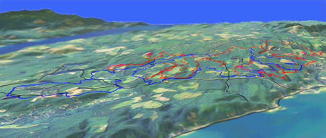
Mission Creek, 1.9 Mile, Deraileur-2, Overland, Nucleus, Tahuya River CCW Loop Elevation Profile Map
The 19mi (2100' ascent) Mission Creek, Overland CCW loop can be extended 6.5mi by riding the 10.5mi (1200' ascent) Overland eastern loop. Tahuya River Trail could also be added to this loop.
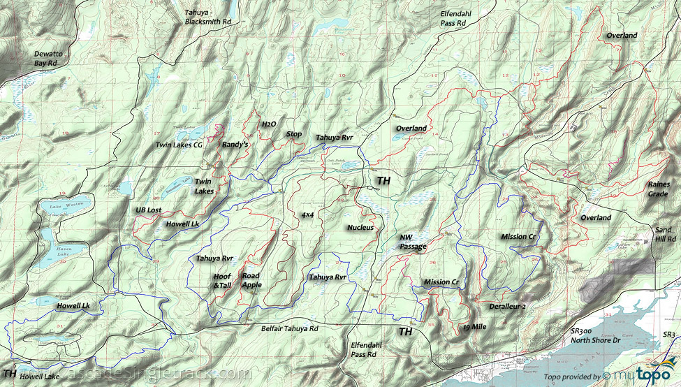
Note: Singletrack trails are marked in red on the Area Map. The green trails are wide doubletrack. Blue trails are often doubletrack, but frequently ridden.
DNR has a very nicely detailed map.
Directions: See Map. From SR3, go to Belfair and go right onto NE Clifton Lane, which becomes SR300, and continue for 3.5mi. Go right onto Belfair Tahuya Road and continue for 1mi to the Mission Creek TH or 9.5mi to the Howell Lake TH. View Larger Map. No Map?.

Loop Directions
lake tour
- TH: From the picnic area, go left onto Howell Lake Trail just prior to reaching the Belfair Tahuya Rd. Pass a few spur trails then descend to the Belfair Tahuya Rd crossing at .3mi. Bear right at the fork, go 1mi then bear left at the fork. The Collins Lake area has many local trails so stick to the marked path.
- 2.6mi: After crossing several creeks, the paved road to Haven Lake and the dirt Bennettsen Lake Rd, go left at the Howell Lake Loop Trail 'T' intersection. Cross Bennettsen Lake Rd at 3.4mi then cross the Tahuya River at 3.9mi and ascend to the Twin Lakes Trail intersection, bearing left the fork just prior to reaching Twin Lakes Trail.
- 4.1mi: Go left onto Twin Lakes Trail, bearing right at the 4.4mi UB Lost Trail intersection near a Tahuya River tributary. Bear right at the 5.1mi UB Lost Trail intersection, then cross a gravel path at 5.3mi, rejoining the trail at 5.5mi. Note: Most of UB Lost Trail is part of a gravel doubletrack, which extends north to Twin Lakes Rd.
- 6.7mi: Go right onto the gravel doubletrack at 6.4mi and continue to Twin Lakes Road, then go right to the Randy's H2O Stop Trail intersection.
- 6.8mi: Go left onto Randy's H2O Stop Trail. Cross a doubletrack at 7.5mi, then go right onto that doubletrack at 8mi. Go left onto the trail at 8.4mi, pass Paul's Grade Trail at 8.9mi, then ride around a clearing to the Tahuya River Trail intersection.
- 9.7mi: Go right onto Tahuya River Trail. Cross Twin Lakes Rd at 10.2mi and go right onto Howell Lake Trail. Pass the 10.8mi Randy's H2O Stop Trail intersection on the right and cross the clearing to the 10.4mi Twin Lakes Trail intersection on the right.
- 13.9mi: Go left onto the Howell Lake Loop Trail, crossing a road at 14.2mi then paralleling the Tahuya River. Ride around a clearing then cross the Belfair Tahuya Rd at 15.1mi. Cross a Tahuya River tributary at 15.6mi then ascend to a 16.1mi clearing before paralleling the Belfair Tahuya Rd back to the TH.
Trail Index
This Ride
1.9 Mile Trail, Deraileur 2 Trail, Howell Lake Trail, Mission Creek Trail, Nucleus Trail, Overland Trail, Rail's Grade Trail, Randy's H2O Stop Trail, Stoffer Trail, Twin Lakes Trail, UB Lost Trail
Area
Beaver Pond Trail, Gold Creek Trail, Gold Creek Trail 830, Hoof and Tail Trail, JBxR Trail, Lower Dungeness Trail 833, Noble Trail, Northwest Passage Trail, Plummer Trail, Lower South Fork Skokomish Trail 873, Raines Grade Trail, Road Apple Trail, Salmon Trail, Sims Trail, Tahuya River Trail, Tin Mine Trail, Tommy Trail, Vista Trail, Wildcat Trail, Wynoochee Lake Shore Trail 878
Capitol Forest
Orv
4x4 Trail
Campgrounds
Belfair State Park Campground, Camp Spillman, Kamenga Canyon CG, Twin Lakes Campground, Tahuya River Horse Camp
Trail Rankings
Ranking consistently applied to all of the listed trails.
- Overall Rating: Ride quality and challenge
- Aerobic: Ascent challenge
- Technical Difficulty: Terrain challenge
- Steepness: Average incline
- Flow: Uninterrupted riding
- Elevation Change: Total elevation gain
- Ride Difficulty: Terrain challenge


