South Fork Skokomish River Tr873
Twitter Search
#skokomishriver

Overall: 6
Aerobic: 5
Technical: 5
Steepness: 5
Flow: 7
Singletrack: 100%
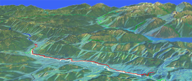
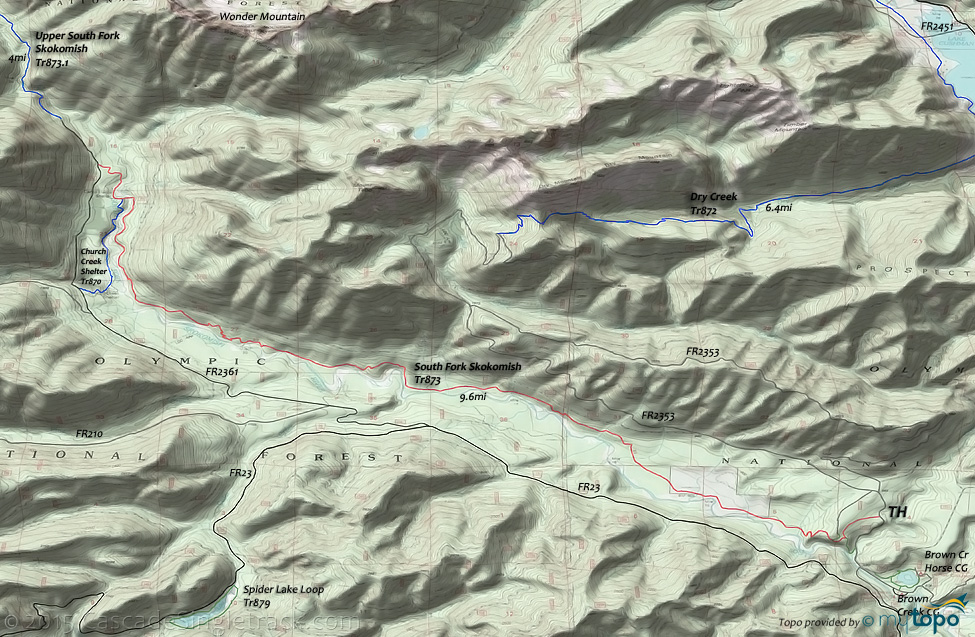
The Skokomish Washington South Fork Skokomish River Trail is a pleasant riverside ascent to the Olympic National Park wilderness boundary.
Type
OAB
Length
Avg: 19mi
Ascent
Easy
Elevation Change
TH:800'
Avg Ascent:4050'
Ascent Incline
9%
Duration
Avg: 4hr
Weather
Forecast
NOAA
popup
USFS
Trail
Review
The ride is long and challenging enough to be considered a destination ride, at least for Beginners and Intermediate riders.
With seven creek crossings, this hillside traverse includes a number of short but steep ascents, challenging for Intermediate riders and requiring some hike-a-bike for Beginners. Likewise, the return is at times too steep for Beginners.
Olympic Elk reside in the river basin and the ride offers many scenic views. The first 6mi of trail offers some of the finest remaining ancient forest in the Northwest, passing the old LeBar Claim, Church Creek Shelter and Harps Shelter along the way.
Nearby: Church Creek Shelter Tr870 is open to biking but favored by equestrians, and Laney Camp hikers. The 2mi Church Creek Tr871 is open to biking, maybe as a spur ride or something else to try if camping in the area. The trail ascends Church Creek, surrounded by old growth trees, crosses a Chapel Peak saddle then passes one of the Satsop Lakes, to the FR2372 TH.
The 7.6mi (3300' ascent) Dry Creek Tr872 is also open to biking, but expect to encounter many hikers from the Lake Cushman and Staircase CG area. From the Staircase CG, the trail meanders 1mi to FR2451, then 1.4mi alongside Lake Cushman (crossing some private land, shown in white on the topo map, so please stay on the trail). The trail then bears right and follows Dry Creek, ascending 700' in the first mile, then crossing relatively flat terrain to the 4.6mi creek crossing, followed by a 1mi, 800' ascent then a more gradual climb to the 7mi Dry Mountain saddle, before descending .7mi to the FR200 TH.
The 2.7mi Pine Lake Tr887.1 is the abandoned FR210, a quiet spur hike or bike option, away from the summer crowds.
Olympic National Park Hiking
The wild Upper Skok is the southern gateway to the Olympic Wilderness.
From the Graves Creek CG, the 17mi (6000' ascent) East Fork Quinalt River Trail ascends gradually for 15mi, past the Pony Bridge, O'Neil Creek, Pyrites Creek and Enchanted Valley camp sites, to the steep (2mi, 2000' ascent) Anderson Pass summit intersection with West Fork Dosewallips River Trail. Be sure to check current conditions, as the Pyrites Creek footlog frequently washes out.
The Enchanted Valley is home to many bears, so bring bear canisters for food and be alert on the trail and in the camp sites.
From the Staircase CG, the 11mi (4900' ascent) North Fork Skokomish River Trail is lowland forest river valley hike through montane forest and subalpine meadow passing Spike Camp, Big Log, Camp Pleasant, Nine Stream, Two Bear and Home Sweet Home camp sites along the way. The lower elevations are suitable year round, with the higher elevations limited to high summer and early fall hiking.
The National Park includes most of the National Forest, with some wilderness areas at the periphery.
Always carry the 10 Essentials: map, compass, flashlight, knife, matches, nylon cord, extra food and water, and rain gear with warm clothes.
The ONP site offers current wilderness trail conditions and map.
For ONP camping permits, go to the Wilderness Information Center (WIC) in Port Angeles. No reservations necessary.
Directions: From the George Adams State Fish Hatchery, go 5.3mi on Skokomish Valley Rd then go right on FR23 and go 9mi to FR2353 and turn right. Cross the South Fork Skokomish River bridge then go .75mi and turn left after crossing the river (just prior to the LeBar Horse Camp entrance), then go .2mi to the TH. View Larger Map. No Map?.

OAB Directions
lowland traverse
- TH: Descend to the river, passing the alternate TH on the right at .5mi.
- 3.9mi: After some river lowland riding and several creek crossings, ascend the hillside cross a bridge, then continue the gradual ascent.
- 8mi: After a number of short but steep hillside ascents, pass Laney Camp on the left and continue to the Church Creek Shelter Tr870 intersection.
- 9.6mi: Pass Church Creek Shelter Tr870 at 9mi (a common turnaround point), with an option to continue the final ascent to FR2361. The section of trail from the end of FR2361 to the park boundary is much more primitive and not suitable for riding.
Olympic National Park Hiking
The southeast section of the park offers several extended loop hiking options, combining Six Ridge Trail, O'Neil Pass Trail, East Fork Quinalt River Trail, Graves Creek Primitive Trail and North Fork Skokomish River Trail, using the Staircase CG or Graves Creek CG as the TH.
Several campsites along North Fork Skokomish River Trail, at Camp Pleasant, Nine Stream Camp and Two Bear Camp.
O'Neil Pass Trail combined with Hart Pass Way Trail, Lacrosse Basin Way and Ranger Pass - Fishers Notch Route, creates some shorter but very challenging loop options from Duckabush Trail.
Sections of Six Ridge Trail require GPS pathfinding, as the trail is not visible.
The Brothers Tr821 passes through a remote canyon area called the Valley of the Silent Men. The Brothers South Couloir Route is a climbing route, requiring advanced climbing skills.
Putvin Tr813 is a high summer hike, starting alongside the Hamma Hamma River in the Boulder Creek Valley, then ascending the steep slopes of Mount Stone, alongside Whitehorse Creek, before reaching an avalanche area, with views of Mount Pershing and Copper Mountain. There are several headwalls to climb, limiting the upper section to advanced climbers. The trail wanders through subalpine forest meadows past the Lake of the False Prophets, then crosses Whitehorse creek.
The easy access, 4mi Lena Lake Tr810 provides access to the Lena Lake CG, so is quite busy in the summer. The hike is relatively flat after the initial 1.4mi, 1400' ascent. The 3.7mi (3100' ascent) Upper Lena Lake Tr811 continues a gradual West Fork Lena Creek Valley ascent for 1.5mi, then ascends steeply to the upper lake.
Trail Index
This Ride
Lower South Fork Skokomish Trail 873
Area
Church Creek Trail 871, Church Creek Shelter Trail 870, Dry Creek Trail 872, Gold Creek Trail 830, Lower Dungeness Trail 833, Wynoochee Lake Shore Trail 878
Green Mountain SF
Beaver Pond Trail, Gold Creek Trail, Pine Lake Trail 887.1, Plummer Trail, Tin Mine Trail, Vista Trail, Wildcat Trail
Tahuya SF
1.9 Mile Trail, Deraileur 2 Trail, Hoof and Tail Trail, Howell Lake Trail, JBxR Trail, Mission Creek Trail, Noble Trail, Northwest Passage Trail, Nucleus Trail, Overland Trail, Rail's Grade Trail, Raines Grade Trail, Randy's H2O Stop Trail, Road Apple Trail, Salmon Trail, Sims Trail, Stoffer Trail, Tayuha River Trail, Tommy Trail, Twin Lakes Trail, UB Lost Trail
Olympic NF Hiking
Jefferson Pass Trail 800, Lena Lake Trail 810, Mildred Lakes Trail 822, Mount Ellinor Trail 812, Mount Rose Trail 814, Putvin Trail 813, Spider Lake Loop Trail 879, The Brothers Trail 821, Upper Lena Lake Trail 811
Olympic NP Wilderness
Black And White Lakes Primitive Trail, Buck Lake Route, Gladys Divide Primitive Trail, Graves Creek Primitive Trail, Hagen Lakes Route, Hart Pass Way Trail, Mount Hopper Way Trail, Mount Olson Way Trail, North Fork Skokomish River Trail, ONeil Creek Route, ONeil Pass Trail, Ranger Pass - Fishers Notch Route, Scout Lake Way Trail, Six Ridge Primitive Trail, Smith Lake Primitive Trail, Sundown Lake Trail
NP Campgrounds
Big Creek Campground, Brown Creek Campground, Graves Creek Campground, Hamma Hamma Campground, Lena Creek Campground, Lilliwaup Campground, Staircase Campground
Trail Rankings
Ranking consistently applied to all of the listed trails.
- Overall Rating: Ride quality and challenge
- Aerobic: Ascent challenge
- Technical Difficulty: Terrain challenge
- Steepness: Average incline
- Flow: Uninterrupted riding
- Elevation Change: Total elevation gain
- Ride Difficulty: Terrain challenge


