Lower Dungeness Tr833 - Gold Creek Tr830
Twitter Search
#dungenesstrail
Overall: 6
Aerobic: 7
Technical: 6
Steepness: 7
Flow: 6
Singletrack: 95%
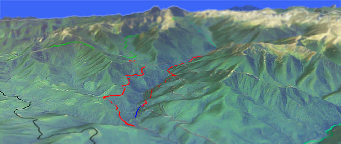
The Sequim Washington Lower Dungeness Trail to Gold Creek Tr830 loop is a challenging looping traverse of the Dungeness River drainage and Dirty Face Ridge, near the Buckhorn Wilderness.
Type
Loop
Length
Avg: 15mi
Ascent
Moderate
Elevation Change
TH:1200'
Avg Ascent:4400'
Ascent Incline
12%
Duration
Avg: 4hr
Weather
Forecast
NOAA
popup
USFS
Trail
Review
Option: Intermediate riders often ascend FR2860 to Three O'Clock Ridge Trail, to avoid the steepest section of Lower Dungeness Tr833.
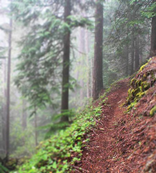
The ride is long and challenging enough to be worth the drive (or ferry ride from Seattle), making this the best destination ride in the Olympic National Forest. Also see Mount Muller Tr882, at the western ONF boundary.
Ding: These trails are also open to motorcycles and horse, so expect some traffic on summer weekends. Also expect some combination of cliff exposure and narrow, technical trail, with some root drop offs along the way.
The ride length is sometimes listed as up to 20mi, which depends on parking and use of FR2860 to ascend to Gold Creek Tr830.
The other Dungeness: There is another Dungeness section open to biking, sometimes called Dungeness Tr833 and more aptly called Lower Big Quilcene Tr833. Accessed from the FR27-080 (lower) TH and the FR27-2750 (upper) TH, this is a 5.9mi (1800' ascent) section which follows the Quilcene river to the Buckhorn Wilderness boundary, crossing the river near the Bark Shanty Shelter, but otherwise a relatively dry ride (five other creek crossings).
Maintain distance from any cougars (or especially their cubs), and back away slowly if needed, arms slowly waving in the air. A ride bell is a good way to help the wildlife maintain distance.
Olympic National Park Hiking
The National Park includes most of the National Forest, with some wilderness areas at the periphery.
To the west of Lower Dungeness Tr833 are 30mi of hiking trails between Gray Wolf River and Deer Ridge, accessible from the Slab Camp TH and Deer Park Rd.
Deer Ridge Trail 846 ascends from the FR2875 Slab Camp TH to the Deer Park Campground, with a sometimes steep (35%) grade. The ridgeline hike continues within the park on Obstruction Point-Deer Park Trail, with Grand Pass or Badger Valley Trail as a connector to Cameron Creek Trail, returning on Gray Wolf Tr834 as a very challenging 36mi loop. Ice axes are recommended for traversing the slope at the top of the Badger Valley Way Trail.
The 18mi (8900' ascent to Gray Wolf Pass) Gray Wolf Tr834 is an easily accessible valley trail which passes through subalpine forest and meadows, with Graywolf, Three Forks, Camp Ellis and Falls Camp sites within the national park boundaries. The trail descends steeply an additional 3mi from Gray Wolf Pass Main Fork Dosewallips River Trail.
The Area Map includes other Buckhorn Wilderness and Olympic National Forest hikes, such as Mount Zion Tr836, Mount Townsend Tr839 and Little Quilcene Tr835.
Main Fork Dosewallips River Trail steadily ascends from 2000' to 4500'. Check conditions, as at last check the Dosewallips Road was washed-out 5.5mi from TH.
The 17mi (5400' ascent) Duckabush River Tr803 is an easy grade for 2.4mi, with a steep and technical section while ascending Big Hump. Five Mile, Ten Mile and Upper Duckabush camp sites are along the way to O'Neil Pass Trail.
Always carry the 10 Essentials: map, compass, flashlight, knife, matches, nylon cord, extra food and water, and rain gear with warm clothes.
The ONP site offers current wilderness trail conditions and map.
For ONP camping permits, go to the Wilderness Information Center (WIC) in Port Angeles. No reservations necessary.
Directions: Turn left off of US101 onto the Louella Rd across from Sequim Bay State Park. Go 1mi, turn left onto Palo Alto which becomes FR28. Go to Road #2880, turn right onto FR2880, go past Dungeness Forks CG 1mi and stay left on FR2870, go 2mi and turn left on FR2870-230. TH is at the end of road. View Larger Map. No Map?.
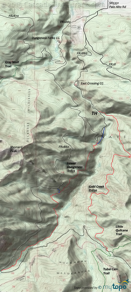
Loop Directions
tubal cain..
- TH: From the Gold Creek Tr830 TH, ascend 1mi to Lower Dungeness Tr833 TH, with the option at .5mi of ascending the spur trail to Lower Dungeness Tr833.
- 1mi: Go left onto Lower Dungeness Tr833. Cross Skookum Creek and Cougar Creek, pass the Three O'Clock Ridge Trail FR2860 connector at 2.7mi, followed by a descent to Dungeness Creek. The ascent includes some cliff exposure and steep ascents, which may result in some hike-a-bike for intermediate riders. Cross Bungalow Creek and several smaller creeks prior to reaching Dungeness Creek. Pass the River Shelter at 4.4mi, then gradually ascend to FR2860.
- 6mi: Cross Mueller Creek, pass the Upper Dungeness (hiking) Tr833 intersection, then go left onto FR2860. After a brief descent, gradually climb alongside Silver Creek to Gold Creek Tr830. The TH is on the left, just prior to the Tubal Cain Tr840 TH (on the right).
- 9.7mi: Go left onto Gold Creek Tr830, crossing a creek and some flat terrain before a brief climb to the ride summit at 10.9mi. At 12.3mi, the Dirty Face Ridge descent gets much more serious, with a steep descent to Gold Creek. Go left at the 13.3mi fork, navigate some switchbacks to a creek crossing, then rip through the final plunge to Gold Creek at 15mi.
Trail Index
This Ride
Gold Creek Trail 830, Lower Dungeness Trail 833
Area
Foothills Trail, Lower Big Quilcene Trail 833, Lower South Fork Skokomish Trail 873, Wynoochee Lake Shore Trail 878
Green Mountain SF
Tahuya SF
1.9 Mile Trail, Deraileur 2 Trail, Hoof and Tail Trail, Howell Lake Trail, JBxR Trail, Mission Creek Trail, Noble Trail, Northwest Passage Trail, Nucleus Trail, Overland Trail, Rail's Grade Trail, Raines Grade Trail, Randy's H2O Stop Trail, Road Apple Trail, Salmon Trail, Sims Trail, Stoffer Trail, Tayuha River Trail, Tommy Trail, Twin Lakes Trail, UB Lost Trail
Buckhorn (numbered) and Olympic NP Wilderness
Badger Valley Trail, Big Quilcene Trail 833.1, Blue Mountain Trail, Cameron Creek Trail, Cedar Lake Primitive Trail, Constance Pass Trail 893, Deer Ridge Trail 846, Duckabush Trail 803, Dungeness Trail 833, Grand Pass Trail, Gray Wolf Trail 834, Heather Basin Trail 863, Lacrosse Pass Trail, Lillian Ridge Way Trail, Little Quilcene Trail 835, Main Fork Dosewallips River Trail, Mount Jupiter Trail 809, Mount Townsend Trail 839, Mount Zion Trail 836, Ned Hill Trail 837, Notch Pass Trail, Obstruction Point-Deer Park Trail, Royal Basin Trail, Silver Creek Way Trail, Silver Lakes Trail 843, Slab Camp Trail 838, Three Forks Trail, Tubal Cain Trail 840, Tunnel Creek Trail 841.1, Tull Canyon Trail 847, Upper Dungeness Trail 833.2
NF Campgrounds
Collins Campground, Deer Park Campground, Dosewallips Campground, Dungeness Forks Campground, East Crossing Campground, Elkhorn Campground, Falls View Campground, Rainbow Campground, Steelhead Campground
Trail Rankings
Ranking consistently applied to all of the listed trails.
- Overall Rating: Ride quality and challenge
- Aerobic: Ascent challenge
- Technical Difficulty: Terrain challenge
- Steepness: Average incline
- Flow: Uninterrupted riding
- Elevation Change: Total elevation gain
- Ride Difficulty: Terrain challenge

