Capitol Forest Trails
Twitter Search
#capitolforest

Overall: 6
Aerobic: 6
Technical: 6
Steepness: 7
Flow: 5
Singletrack: 100%
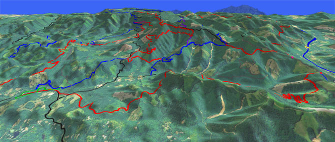
The Olympia Washington Capitol Forest is a 91,650 acres (150 square mile) DNR state forest (located in the Black Hills, south of Olympia), the largest non-USFS MTB trail system in the Northwest.
Type
Loop
Length
Avg: 15mi
Ascent
Moderate
Elevation Change
TH:400'
Avg Ascent:3550'
Ascent Incline
9%
Duration
Avg: 3hr
Weather
Forecast
NOAA
popup
DNR
Trail
Review
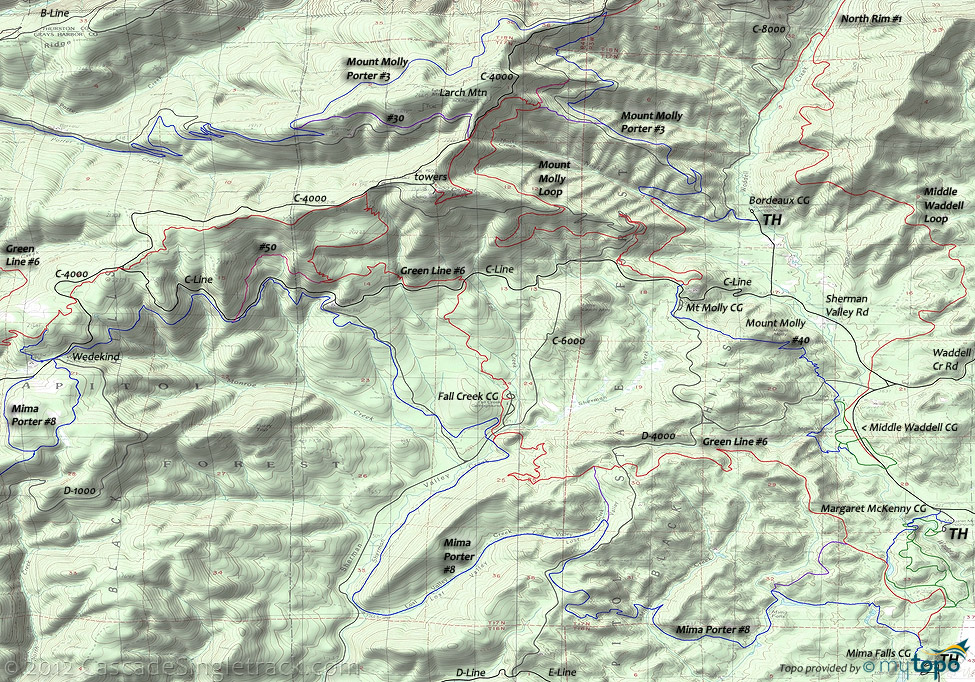
The trails in the northern half of the forest are open to ORV. The Area map shows the major roads, however the area is covered in abandoned logging roads and the forest continues to be actively logged, so a GPS is strongly suggested. Some topo maps have incorrect elevation data. The Larch Mountain-Rock Candy Mountain ridgeline is ~2300' and most of the campgrounds are 400'-600', so expect some strenuous ascents and relatively steep terrain.
The primary trails can be combined to form 40mi loop rides, but the average ride is ~15mi. North of C-Line and south of Rock Candy Mtn, the terrain is steep enough to require a road climb.
WA DNR has a very detailed map on their trail conditions page.
From the Waddell CG, the Middle Waddell Loop traverses the hill east of Sherman Valley Rd, to North Rim Tr1, with 6 road and 3 bridge crossings along the way as the trail crosses 23 hillside drainages.
North Rim Tr1 circumnavigates the northern half of Capitol Forest, from the Middle Waddell Loop and C-8200, to the B-Line Porter Creek CG. The ride can either be combined with the Rock Candy Trails, or use some double track at the northern end to connect the two sections of North Rim Tr1 singletrack. As with most of the other trails in this wet terrain, expect to cross dozens of small streams, with culverts over the larger crossings.
Rock Candy East Trail (2.4mi, 1150 ascent or 9% grade) is an easily accessible, but steep, connector from B-Line to North Rim Tr1
Mount Molly Porter Tr3 and Green Line Tr6 are the two major E-W trails, with Mima Porter Tr8 defining the southern trail system boundary. Although most riders choose the southeastern slopes, much larger loops are possible, for those with advanced climbing skills and plenty of time.
To prevent trail damage, all trails are closed to biking during the winter months, usually between November 1st and March 31st. Check the DNR site for current conditions.
Mount Molly Loop Tr40 is a common ride, ascending Sherman Valley Rd, C-Line and C-4000 to the Delphi towers, then traversing the hillside north to Mount Molly Porter Tr3 before crossing the Noski Creek headwaters and descending to the Mount Molly CG and on to the Waddell CG TH.
As an alternative, the 13mi (2900', 7% ascent) option shown on the profile map descends Mount Molly Porter Tr3 to the Bordeaux CG.
From the Mima Falls CG, the 18mi (4100', 12% ascent) CW Loop includes two steep ascents to D-4000 but is an easy access loop well suited for intermediate riders. Expect equestrian encounters on this loop ride.
Directions: See Map. Waddell and Rock Candy are the primary trailheads. View Larger Map. No Map?.

Loop Directions
molly green loop
- TH: Ascend Mt Molly Tr40 from the Middle Waddell TH, around the CG and across Waddell Creek. At 1mi, go left at the fork (Yew Tree CG). Cross D-4800 at 1.4mi, and ascend to Mt Molly, crossing a doubletrack at 1.9mi.
- 2.8mi: Summit Mt Molly then cross D-4900.
- 3.3mi: Cross D-4000 then pass the Mt Molly CG. Pass several side trails to the CG then at 4.1mi go left onto C-Line.
- 5.7mi: Cross Fall Creek on C-Line, then go left onto Green Line Tr6 and descend the steep slope to the Fall Creek CG at 7.4mi. Logging on this slope requires some pathfinding. While crossing the clearcut, dogleg left at the logging road to rejoin the trail, then once back in the woods, dogleg to the right on C-5200 at 6.8mi.
- 7.8mi: Past the Fall Cr CG, cross C-6000 and ascend the steep switchbacks to D-4000, passing the Mima Porter Tr20 intersection at 9.9mi, near the Lost Valley Creek headwaters. Parallel then cross D-4600 at 11.1mi, then descend the steep slope past the 13.1mi Mima Falls Tr10 intersection.
- 13.5mi: Go left onto Green Line Tr6A and ride through various Waddell Loop intersections near the Margaret McKenny CG, to Waddell Cr Rd and back to the TH.
Trail Index
This Ride
Green Line Trail 6, Mount Molly Trail 40
Area
Trail 50, Beaver Pond Trail, Gold Creek Trail, Gold Creek Trail 830, Lower Dungeness Trail 833, Mima Falls Trail 10, Mima Porter Trail 8, Mima Porter Trail 20, Plummer Trail, Lower South Fork Skokomish Trail 873, Tin Mine Trail, Vista Trail, Waddell Loop Trail, Wildcat Trail, Wynoochee Lake Shore Trail 878
Tahuya SF
1.9 Mile Trail, Deraileur 2 Trail, Hoof and Tail Trail, Howell Lake Trail, JBxR Trail, Mission Creek Trail, Noble Trail, Northwest Passage Trail, Nucleus Trail, Overland Trail, Rail's Grade Trail, Raines Grade Trail, Randy's H2O Stop Trail, Road Apple Trail, Salmon Trail, Sims Trail, Stoffer Trail, Tayuha River Trail, Tommy Trail, Twin Lakes Trail, UB Lost Trail
Orv
Trail 30, Middle Waddell Loop Trail, Mount Molly Loop Trail, Mount Molly Porter Trail 3, North Rim Trail 1, Rock Candy East Trail, Rock Candy West Trail
Campgrounds
Bordeaux Campground, Fall Creek Campground, Margaret McKenny Campground, Middle Waddell Campground, Mima Falls Campground, North Creek Campground, Porter Creek Campground, Sherman Valley Campground, Yew Tree Campground
Trail Rankings
Ranking consistently applied to all of the listed trails.
- Overall Rating: Ride quality and challenge
- Aerobic: Ascent challenge
- Technical Difficulty: Terrain challenge
- Steepness: Average incline
- Flow: Uninterrupted riding
- Elevation Change: Total elevation gain
- Ride Difficulty: Terrain challenge


