
Edison Butte to Lava Lake Tr31
Twitter Search
#EdisonTrail

Overall: 7
Aerobic: 6
Technical: 4
Steepness: 5
Flow: 8
Singletrack: 100%
The Bend Oregon Edison Butte to Lava Lake Tr31 is a straightforward OAB ride, which also serves as the southern High Cascades 100 MTB Race segment.
Type
OAB
Length
Avg: 20mi
Ascent
Moderate
Elevation Change
TH:5000'
Avg Ascent:2700'
Ascent Incline
8%
Duration
Avg: 4hr
Weather
Forecast
NOAA
popup
USFS

The 'twin peaks' ride profile is unusual but manageable, and the terrain is moderate and steady.
Those seeking an easier ride can turn around at the 5.5mi Snowmobile #4 Tr8004 intersection (between Sheridan mountain and Kwohl butte)and spend some time winding around the extensive Edison XC Ski trail system.
The Lava Lake campground is the other TH choice, with more riding options such as the Lava Lake to Sparks Lake ride.
The west side of the trail is all singletrack, with the east side open to ORV, up to the Snowmobile #4 Tr8004 intersection. The damage to that section of trail will vary from year to year and the west side is an easier ascent.
So, enjoy the views of Broken Top, Mount Bachelor and Tumalo mountain and be ready for a long ride.
The ride can be extended by adding Tumalo Mountain Connector Tr40 and connecting to the Wanoga trails.
Directions: SR46W (Cascade Lakes Hwy) for 18mi from Bend, then turn left at the Sunriver FR45 turnoff. Drive 6mi to the Edison Sno-Park TH and park in the south end of the Sno-Park. View Larger Map. No Map?.

OAB Directions
rocky
Edison Butte, Lava Lake Area Topo Map
- TH: From the Edison Sno-Park TH
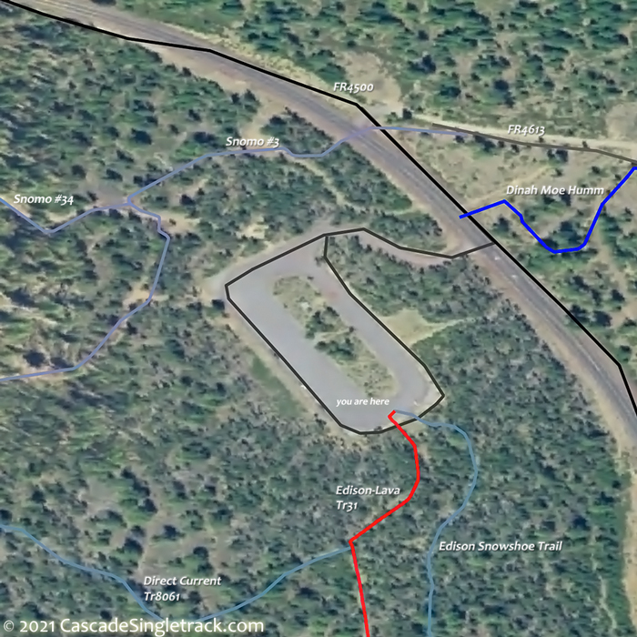
View of the Edison Sno-Park TH, ride through the gauntlet of XC Ski trails, reaching the Edison Ice Caves at 1.4mi and Supercharger Tr8065 at 2mi..
- 5.4mi: After a steady ascent, pass the Snowmobile #4 Tr8004 intersection and descend to the Little Lava campground.
- 10mi: Reach the Metolius-Windigo Tr99 intersection and return to the TH. Due to wilderness restrictions, trails west of the Cascades Hwy are off limits to biking.


Edison SnoPark Trails

Covered on the Area map, the 5000' elevation Edison Sno Park has about 23mi of XC Ski and dedicated Snowshoe trails. The Area Map also shows the area Snomobile trails.
See the Deschutes NF Edison Snopark page for Nordic, Snomo and OHV maps.
Trail Index
This Ride
Edison-Lava Trail 31, Metolius-Windigo Trail 99, Snowmobile #4 Tr8004, Snowmobile #40 Tr8004.3
Area
Appaloosa Trail 13.2, Bens Trail 50, COD Trail 71, Cultus: Deer Lake Trail 6, Deschutes River Trail 2.3, Elfin Magic Trail 45, Farewell Trail 26, Flagline Access Trail 40.1, Flagline Trail 41, Flagline Tie Trail 41.1, Funner, Grand Slam Trail 44, Katsuk Pond Trail 13, Kents Trail 43, KGB Trail 72, Many Lakes Trail 15, Mrazek Trail 32, MTB Trail 51, North Fork Trail 24.2, Phils Trail 42, Quinn Creek Trail 1, Sector 16 Trail 27, Skyliners Trail 28, South Fork Trail 25, Sparks Lake Trail 4, Storm King Trail 48, Swampy Lake Trail 23, Swampy Loop Trail 23.2, Swampy-Dutchman Trail 40, Swede Ridge Trail 52, Tiddlywinks, Tumalo Creek Trail 25.1, Tumalo Ridge Trail 25.2, Voodoo Trail 46, Winopee Tie Trail 16.5
XC Ski
Alternating Current Trail 8062, Big Meadow Trail 52, Direct Current Trail 8061, Dynamo Trail 8066, Edison Snowshoe Trail 8093, High Voltage Trail 8063, Light Bulb Loop, Lower Loop Trail 40, Old Growth Trail 8067, Petes Way Trail 56, Pondo Loop Trail 8068, Shelter Tie, Supercharger Trail 8065,Todd Lake Trail 54, Todd Ridge Trail 55, Water Tower Trail 53
Campgrounds
Beach Campground, Deschutes Bridge Campground, Devils Lake Campground, Elk Lake Campground, Lava Lake Campground, Mallard Marsh Campground, Mile Campground, Point Campground, Sparks Lake Campground, Upper Campground
Trail Rankings
Ranking consistently applied to all of the listed trails.
- Overall Rating: Ride quality and challenge
- Aerobic: Ascent challenge
- Technical Difficulty: Terrain challenge
- Steepness: Average incline
- Flow: Uninterrupted riding
- Elevation Change: Total elevation gain
- Ride Difficulty: Terrain challenge
