
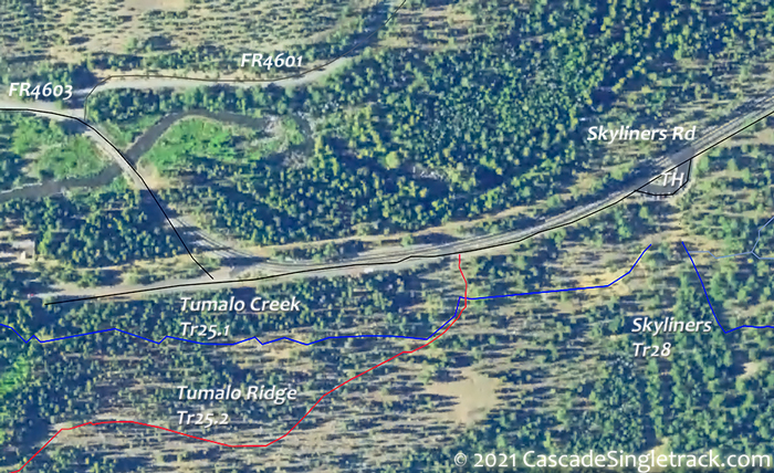
Tumalo Creek Tr25.1 and Tumalo Ridge Tr25.2
Twitter Search
#tumalotrail
#bendtrails

Overall: 10
Aerobic: 7
Technical: 6
Steepness: 5
Flow: 9
Singletrack: 99%
Besides the typical Tumalo Falls ride on Tumalo Cr Tr25.1 (maybe extended with North Fork Tr24.2), the Bend Oregon Tumalo area offers several progressively Intense loop possibilities when combined with Swampy Lake Tr23 (especially when extended to an epic Metolius-Windigo Tr99 to Flagline Tr41 loop), returning on Tumalo Ridge Tr25.2.
Type
Loop
Length
Avg: 18.5mi
Ascent
Intense
Elevation Change
TH:4750'
Avg Ascent:4000'
Ascent Incline
8%
Duration
Avg: 5hr
Weather
Forecast
NOAA
popup
USFS
Tweets

As with Phils Tr42, the Tumalo trail system is an example of how great trail systems offer flexible trail design, enabling OAB or loops on the same trails, in either direction.
CCW loops rides on this system are somewhat easier than CW and Swampy Lake Tr23 would be a challenging climb, but the Tumalo Falls, Swampy Lakes and Metolius-Windigo intersections create a highly flexible trail system and several epic ride options.
The 25.3mi Tumalo Epic (described at the bottom of the page) is a limited-time offer, since Flagline Tr8041 is only open from Mid-Aug till it becomes snowed-in again, so get it while you can.
The ride can be extended by replacing the FR100-Tumalo Ridge Tr25.2 section with Skyliners Tr28, Sector 16 Tr27 and Whoops (part of the Phils Tr42 trail system).
Combining Tumalo Creek Tr25.1 with North Fork Tr24.2 and Farewell Tr26 creates an exciting 12.7mi (2650' ascent) loop, long enough to be a destination ride while also offering great scenic views as riders ascend the north fork of Tumalo Creek.
Once at the upper North Fork Tr24.2 TH, the ride can be easily converted into several great loop rides, described below.
Note: South Fork Tr25 is the trail which extends north from the Swampy Lakes shelter, past an intersection with the Bridge Creek Tr24 hiking trail. The maps have been revised to show that Bridge Creek Tr24 north and west of the intersection with South Fork Tr25 are for hiking and should not be ridden. Try looping North Fork Tr24.2 with Mrazek Tr32 and Farewell Tr26, or use Metolius-Windigo Tr99 to create a much larger loop, as described below.
Tumalo Epic (25.3mi, 4700' ascent)

TH: The ride starts at the FR430 intersection (FR430 goes to Tumalo Lake). It's easy to head in the wrong direction from the Tumalo TH, so check the map or ask a rider. Go right and follow the doubletrack for 1.3mi. Bear left at the fork and the trail turns to singletrack. Expect hikers on this easily accessed trail section.
2.3mi: Cross the south fork of the Tumalo Creek then go right onto South Fork Tr25. At the Tumalo Falls TH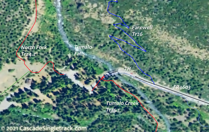
View of the Tumalo Falls TH, go right onto North Fork Tr24.2 at 2.7mi and hike-a-bike .3mi to the top of the falls, then ascend North Fork Tr24.2. Bear left at 3.2mi, past several Falls viewpoint trails.
5.2mi: Cross the middle fork of Tumalo Creek and ascend to Bridge Creek Tr24 (hiking trail so don't ride this section), the steepest section of this ride.
6.3mi: Go right onto Bridge Creek Tr24 and continue climbing to Metolius-Windigo Tr99.
6.8mi: Go left onto Metolius-Windigo Tr99 and complete the second big ascent of this ride, climbing out of North Fork Tumalo Creek drainage. Called Happy Valley, the happiness comes at 9.6mi, as the descent begins to Flagline Tr41.
12.2mi: Go left onto Flagline Tr41 and ascend 600' along the side of Tumalo Mountain, to the ride summit at 14mi. Descend to the Swampy Lakes Shelter intersection, passing Flagline Tie Tr41.1 on the right at 17mi.
18.3mi: Go left, to the Swampy Lakes Shelter, then go right onto Swampy Loop Tr23.2 and ride around the northern side of the swamp to Swede Ridge Tr52. 
18.9mi: Go left onto Swede Ridge Tr52 and descend the ridgeline to the Swede Ridge Shelter.
20.8mi: The singletrack ends at FR100, near the Swede Ridge shelter and the intersection with Sector 16 Tr27. go left onto FR100 (towards the Swede Ridge shelter).
22.7mi: Go right onto the second doubletrack on the right, then go then right onto Tumalo Ridge Tr25.2. Ride to the edge of the ridge at 16.9mi, then descend the steep ridge side.
25mi: Bear right at the fork and head back to the TH.


Directions: From US97 go west 1.2mi on NW Franklin Ave to NW Tumalo Ave. Turn right then Tumalo becomes NW Galveston Ave and then Skyliners Rd. After 10.7mi, turn into the Skyliners Sno-Park TH. View Larger Map. No Map?.


Loop Directions
swampy
- This very popular 12.5mi (2000' ascent) moderate 2.5hr ride which is about as challenging as the Tumalo Creek Tr25.1 to North Fork Tr24.2 ride.
- TH: The ride starts at the FR430 intersection (FR430 goes to Tumalo Lake). It's easy to head in the wrong direction from the Skyliners Sno-Park TH
View of the Skyliners Sno-Park TH, so check the map or ask a rider. Go right and follow the doubletrack for 1.3mi. Bear left at the fork and the trail turns to singletrack. Expect hikers on this easily accessed trail section. - 2.3mi: Cross the south fork of the Tumalo Creek then go left onto South Fork Tr25 and ascend to Swampy Lake Tr23.
- 3.8mi: At the Bridge Creek Tr24 intersection, bear left on South Fork Tr25 and complete the Swampy Lake ascent, with some switchbacks leading past a small crescent lake. Go left at the 5.6mi Swampy Loop Tr23.2 fork (near the Swampy Lakes shelter) and ride across the northern side of Swampy Lakes, then at 6mi go left at the Swede Ridge Tr52 intersection.
- 14mi: Swede Ridge Tr52 ends at FR100, at the intersection with Sector 16 Tr27. Go left onto FR100 (towards the Swede Ridge shelter).
- 7.9mi: Go right onto the second doubletrack on the right, then go then right onto Tumalo Ridge Tr25.2. Ride to the edge of the ridge at 9.8mi, then descend the steep ridge side.
- 12.1mi: Bear right at the fork and head back to the TH.


Trail Index
This Ride
North Fork Trail 24.2, South Fork Trail 25, Swampy Lake Trail 23, Swampy Loop Trail 23.2, Swede Ridge Trail 52, Tumalo Creek Trail 25.1, Tumalo Ridge Trail 25.2
Area
Bens Trail 50, COD Trail 71, Deschutes River Trail 2.3, Elfin Magic Trail 45, Farewell Trail 26, Flagline Trail 41, Flagline Access Trail 40.1, Flagline Tie Trail 41.1, Funner, Grand Slam Trail 44, Kents Trail 43, KGB Trail 72, Metolius-Windigo Trail 99, Mrazek Trail 32, MTB Trail 51, Phils Trail 42, Sector 16 Trail 27, Skyliners Trail 28, Storm King Trail 48, Swampy-Dutchman Trail 40, Tiddlywinks, Voodoo Trail 46
Trail Rankings
Ranking consistently applied to all of the listed trails.
- Overall Rating: Ride quality and challenge
- Aerobic: Ascent challenge
- Technical Difficulty: Terrain challenge
- Steepness: Average incline
- Flow: Uninterrupted riding
- Elevation Change: Total elevation gain
- Ride Difficulty: Terrain challenge
