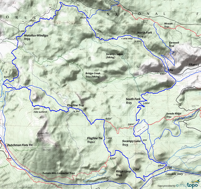
Swampy Lakes Tr23 to Swede Ridge Tr52
Twitter Search
#swampylakestrail
#bendtrails
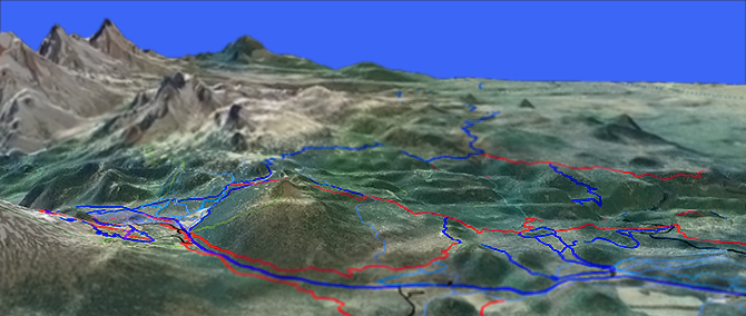
Overall: 9
Aerobic: 6
Technical: 5
Steepness: 5
Flow: 9
Singletrack: 100%
The Bend Oregon Swampy Lakes Trail is a North-South route which connects Cascade Hwy to Flagline Tr41 and terminates at Metolius-Windigo Tr99. The Swampy Lakes area serves as a hub for several great loop rides, from moderate to epic.
Type
Loop
Length
Avg: 11.5mi
Ascent
Moderate
Elevation Change
TH:5800'
Avg Ascent:1500'
Ascent Incline
4%
Duration
Avg: 2.5hr
Weather
Forecast
NOAA
popup
USFS
Swede Ridge Tr52 connects Swampy Lakes Tr23 to Tumalo Ridge Tr25.2 and to the Phils Tr42 trail system.
Due to an average 6000' elevation, the Swampy Lakes area is very popular for winter sports.
Awesome stuff, but many of the trails have multiple names, leading unwary bikers onto long, unintended doubletrack ventures.
As with all the other ride descriptions on this site, some attempt has been made to clearly define the mountainbike-related trails.
An 11.5mi (1500' ascent) CW Loop of Swampy-Dutchman Tr40 and Flagline Tr41 to Swede Ridge Tr52 and Swede Ridge Loop Tr8026 provides enough ride time to be a destination ride while still covering moderate terrain.
Note: Swede Ridge Loop Tr8026 is a XC Ski trail, largely consisting of doubletrack.
The Tumalo Tr25.2 page describes a northern 12.5mi (2000' ascent) CCW loop, which utilizes most of Swampy Lake Tr23 and Swede Ridge Tr52, combined with Tumalo Creek Tr25.1, Tumalo Ridge Tr25.2 and North Fork Tr24.2.
Because the Tumalo TH is the lowest elevation of that loop, it's best to ride that great loop from the Tumalo TH rather than from the Swampy Lakes Sno-Park TH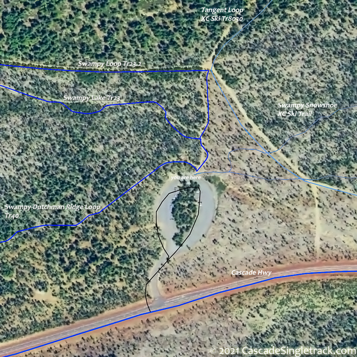
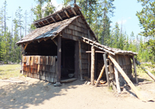
View of Swampy Lakes Sno-Park TH.
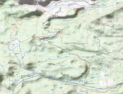
South of Swampy Lakes Tr23, Swampy Loop Tr23.2, Swede Ridge Tr52 and Swede Ridge Loop Tr8026 combine to create a very popular 8mi (1000' ascent) CCW loop, short and moderate enough for most intermediate riders but not long enough to be a destination ride.
The ride profile is inverted (the ride low is at the Swede Ridge Shelter intersection) but the terrain is moderate enough to not be a problem.
Swampy Lake Epic
Note: Flagline Tr41 is only open from Mid-Aug till it becomes snowed-in again, limiting the access to this ride.
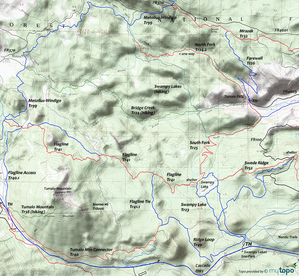
TH: Start this 24mi (3900' ascent) ride ascending Swampy Lake Tr23 to Metolius-Windigo Tr99. Go onto the leftward trail at the end of the parking lot, then go right onto Swampy Lake Tr23 and bear left at the next fork to stay on the trail. Ascending the Swampy Loop Tr23.2 doubletrack would be another option. After navigating some loose trail conditions during the creek drainage ascent, pass Swede Ridge Loop Tr8026 on the right at .8mi, then descend to the Swampy Lake Tr23 intersection.
2mi: Just past the Flagline Tr41 intersection on the left, go around the Swampy Shelter, then go left onto South Fork Tr25 and descend through the switchbacks to to North Fork Tr24.2, then ascend to Metolius-Windigo Tr99.
9.7mi: Go left onto Metolius-Windigo Tr99 and complete the second big ascent of this ride, climbing out of North Fork Tumalo Creek drainage. Called Happy Valley, the happiness comes at 12.6mi, as the descent begins to Flagline Tr41.
15.1mi: Go left onto Flagline Tr41 and ascend 600' along the side of Tumalo Mountain, to the ride summit at 17.1mi. Descend to Flagline Tie Tr41.1.
20mi: Go right onto Flagline Tie Tr41.1, covering relatively flat terrain to Swampy-Dutchman Tr40/Ridge Loop Tr23.2 intersection.
21.1mi: Go left onto Ridge Loop Tr23.2 and descend to the TH.
Note: South Fork Tr25 is the trail which extends north from the Swampy Lakes shelter, past an intersection with the Bridge Creek Tr24 hiking trail. The maps have been revised to show that Bridge Creek Tr24 north and west of the intersection with South Fork Tr25 are for hiking and should not be ridden. Try looping North Fork Tr24.2 with Mrazek Tr32 and Farewell Tr26, or use Metolius-Windigo Tr99 to create a much larger loop, as described below.
Directions: The Swampy Lakes Sno-Park TH is 16mi west of Bend on Cascade Hwy. View Larger Map. No Map?.
Loop Directions
swampy 'ridge' loop
Swampy Lakes Swede Ridge Area Topo Map
- TH: From the end of the Swampy Lakes Sno-Park TH parking circle, go on the left (western) trail, then bear left to remain on Swampy-Dutchman Tr40 and ascend to the ride summit, at the Flagline Tie Tr41.1 intersection.
- 2.7mi: Go right onto Flagline Tie Tr41.1 and ride across the ridge to Flagline Tr41 at 3.8mi. Go right and ride to the Swampy Lakes Shelter intersection.
- 5.1mi: Go left, to the Swampy Shelter / Shack / Woodshed, then go right onto Swampy Loop Tr23.2 and ride around the northern side of the swamp to Swede Ridge Tr52.
- 5.8mi: Go left onto Swede Ridge Tr52 and descend the ridgeline to the Swede Ridge Shelter.
- 7.7mi: The singletrack ends at FR100, near the Swede Ridge shelter. Go right onto FR100, around the curve, to the 8.4mi fork. Bear right and continue to the Swede Ridge Loop Tr8026 intersection on the left, just prior to the end of the doubletrack. Pass a doubletrack on the left at 8.8mi.
- 10.3mi: At the clearing, at the 4 way intersection either go left onto Swampy Loop Tr23.2 and ride back to the TH, or continue on to Swampy Lake Tr23 and head back to the TH.
Swampy, Vista Butte and Virginia Meissner Snopark XC Ski and Nordic Trails
The Swampy Lakes and other nearby Snoparks are at the minimum elevation needed for nordic sports, providing a long winter season of snowshoeing and XC Ski activities.
Swampy Lakes Loop Tr23 is a very popular loop, sometimes combined with Swede Ridge Trail 52, with both covering moderate terrain. Tangent Loop Trail 30 and Nordeen Loop Trail 31 also have a moderate elevation profile, with Wednesdays Trail 32 and the Meissner Snowshoe Trail 91 covering a more varied terrain.
Trail Index
This Ride
Flagline Trail 41, Flagline Access Trail 40.1, Flagline Tie Trail 41.1, Metolius-Windigo Trail 99, Swampy Lake Trail 23, Swampy Loop Trail 23.2, Swede Ridge Trail 52
Area
Bens Trail 50, COD Trail 71, Deschutes River Trail 2.3, Elfin Magic Trail 45, Farewell Trail 26, Funner, Grand Slam Trail 44, Kents Trail 43, KGB Trail 72, Mrazek Trail 32, MTB Trail 51, North Fork Tr24.2, Phils Trail 42, Sector 16 Trail 27, Skyliners Trail 28, South Fork Tr25, Storm King Trail 48, Swampy-Dutchman Trail 40, Tiddlywinks, Tumalo Creek Tr25.1, Tumalo Ridge Tr25.2, Voodoo Trail 46
XC Ski
Knotweed Trail 30.1, Lower Loop Trail 40.1, Lupine Trail 34, Manzanita Trail 36, Meissner Snowshoe Trail 91, Nordeen Loop Trail 31, Paintbrush Trail 38, Penstemon Trail 33, Swampy Snowshoe Trail 92, Tangent Loop Trail 30, Shooting Star Trail 39, Snowbush Trail 37, Wednesdays Trail 32, Wild Strawberry Trail 32.5
Trail Rankings
Ranking consistently applied to all of the listed trails.
- Overall Rating: Ride quality and challenge
- Aerobic: Ascent challenge
- Technical Difficulty: Terrain challenge
- Steepness: Average incline
- Flow: Uninterrupted riding
- Elevation Change: Total elevation gain
- Ride Difficulty: Terrain challenge


