Ravens Roost: South Fork Tr946 to Middle Fork Little Naches River Tr945
Twitter Search
#NorsePeakWilderness

Overall: 6
Aerobic: 6
Technical: 6
Steepness: 7
Flow: 5
Singletrack: 90%
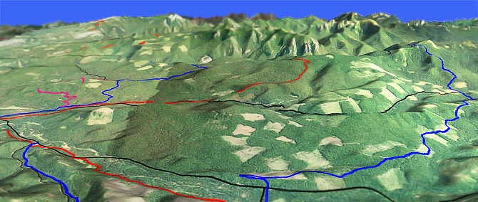
The Ellensburg Washington South Fork Trail leads to Ravens Roost and a somewhat technical Middle Fork Little Naches River Tr945 descent, at the edge of the Norse Peak Wilderness.
Type
Loop
Length
Avg: 19mi
Ascent
Intense
Elevation Change
TH:3150'
Avg Ascent:4600'
Ascent Incline
12%
Duration
Avg: 4hr
Weather
Forecast
NOAA
popup
USFS
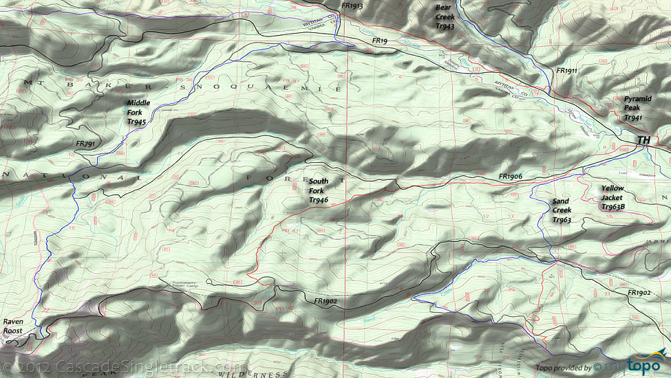
South Fork Tr946 and Middle Fork Tr945 are connected by a portion of FR1902 and Pyramid Peak Tr941, near the Bear Creek Tr943 to Mount Clifty Tr947 loop ride.
Ding: If the 2.5mi of 12% ascent seems like too much (and would be for most intermediate riders), then use Sand Creek Tr963 and 6.3mi of the 7.5% grade FR1902 for the Raven Roost ascent.
The most interesting downhill is in the first 1.5mi on Middle Fork Tr945, a 1700' descent, or 20% grade.
The steep downhill comes at the usual cost, which is the long climb to get to the top, although shuttling FR1902 is certainly an option.
Like all other steep Cascade Range descents, every degree of downhill grade greater than 10% multiplies the miles of climbing.
With a typical sustained climbing ability of 7%-10% for most riders, getting to the top of a 1mi, 20% grade downhill takes about 3mi of climbing.
In this case the ratio is 4.6mi of South Fork Tr946 ascent (4200'-5900') for the 1.5mi Middle Fork Tr945 descent back to 4200'.
A good example of this rule is Pot Peak Tr1266, which pays off in a long enough descent to make all that climbing worth it.
Like most of the other advanced rides in the Cascade Range, it pays to find terrain which suits the riders preferences and skill level.
Norse Peak Wilderness Hiking: The Area map shows a couple of hiking options from the Ravens Roost comm site, using Pacific Crest Tr2000-I to connect Raven Roost Tr951 and Louisiana Saddle Tr945A, or for a shorter, easier hike, shuttle from Raven Roost to SR410 and descend Cougar Valley Tr951A to Crow Lake Way Tr953. Crow Lake Way Tr953 ties into Pleasant Valley Loop Tr999 near the SR410 Pleasant Valley CG.
The Greenwater Lakes hiking trails are shown on the Noble Knob Tr1184 page.
Directions: SR410 to FR19 to FR1906 (not shown on Google map). Park beside the road. View Larger Map. No Map?.

Loop Directions
lookout
- TH: From the FR1909 TH ascend South Fork Tr946, which crosses FR686 then crosses to the left side of FR1906 at .8mi, then parallels Sand Creek Tr963 before crossing to the right side of FR1906 at 2.1mi, finally veering off to the left of FR1906 at 2.5mi.
- 2.5mi: After crossing FR1906, hike-a-bike up the steep slope to the knoll ridgeline, which will be up to .5mi depending on climbing ability. After passing the knoll on the right, continue the steep ascent to FR1902.
- 5mi: Cross the ridgeline and go right onto FR1902, near the Sand Creek headwaters. Pass FR865 and the Huckleberry Forest Camp on the right at 6.2mi, followed by a final push to the Middle Fork Tr945 intersection.
- 7.8mi: Go right onto Middle Fork Tr945 at the fork (the ride summit), with an option to continue .6mi (300' ascent) on FR1902 to the Raven Roost peak. Continue along the left side of ridge then switchback steeply into the valley.
- 10.2mi: Pass FR1906 on the right at 9.7mi, descend to and cross the South Fork Little Naches River bridge, followed by a steep but brief climb to a T. Go right then cross FR791 and parallel FR884 on the right, then descend to the County Creek drainage and ride alongside FR1912 across moderate terrain, crossing it several times before switchbacking to FR19.
- 14.5mi: Cross FR19 then use FR1913 to cross the Little Naches River, and go right onto Pyramid Peak Tr941 and ride the riverside terrain back to the South Fork Tr946 TH, then ride back to the FR1906 TH.
Trail Index
This Ride
Middle Fork Trail 945, Pyramid Peak Trail 941, Sand Creek Trail 963, South Fork Trail 946, Yellow Jacket Trail 963B
Area
Bear Creek Trail 943, Cub Creek Trail 943A, Fifes Ridge Trail 954, Legos Trail 942, Naches Pass Trail 4W684, West Quartz Creek Loop Trail 952
Wilderness
Cougar Valley Trail 951A, Crow Lake Way Trail 953, Louisiana Saddle Trail 945A, Maggie Creek Trail 1186, Pacific Crest Trail 2000-I, Raven Roost Trail 951
Campgrounds
American Forks Campground, Cedar Springs Campground, Cottonwood Campground, Crow Creek Campground, Halfway Flat Campground, Hells Crossing Campground, Indian Flat Campground, Jungle Creek Campground, Kaner Flat Campground, Little Naches Campground, Lodgepole Campground, Pine Needle Campground, Pleasant Valley Campground, Sawmill Flat Campground
Trail Rankings
Ranking consistently applied to all of the listed trails.
- Overall Rating: Ride quality and challenge
- Aerobic: Ascent challenge
- Technical Difficulty: Terrain challenge
- Steepness: Average incline
- Flow: Uninterrupted riding
- Elevation Change: Total elevation gain
- Ride Difficulty: Terrain challenge


