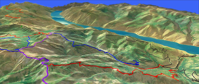
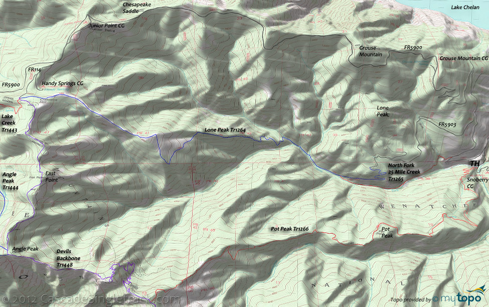
Devils Backbone to Pot Peak Orv Tr1266
Twitter Search
#PotPeakTrail

Overall: 8
Aerobic: 10
Technical: 8
Steepness: 8
Flow: 7
Singletrack: 30%
A 10mi (9% grade) dirt fireroad climb is epic...but not in a good way. If there were ever a reason to shuttle, the Chelan Washington Pot Peak Trail is it.
Type
Loop
Length
Avg: 28mi
Ascent
Mt Goat
Elevation Change
TH:1900'
Avg Ascent:9200'
Ascent Incline
9%
Duration
Avg: 8hr
Weather
Forecast
NOAA
popup
USFS
Otherwise, get ready for a 10mi steep forest road climb. The payoff is a downhill which has been described as one of the best in the Cascade Range.
Ding: The rating takes a hit for the excessive road climb and for the area being open to ORVs, but otherwise this is one of the must-do Cascade rides, so find a good friend and shuttle this ride.
North Fork 25 Mile Creek Orv Tr1265 and Lone Peak Orv Tr1264 are the other two major Lake Chelan area rides with nearby trailheads.
Lake Creek Tr1443 ascends to Devils Backbone Orv Tr1448 from the Entiat side of the ridge.
A 4-6hr climb for 2.5hr of singletrack? The typical route (described in the route guide below) is to climb from the Pot Peak Orv Tr1266 TH on FR5900, to FR114 at the Handy Spring Campground, then ride Devils Backbone Orv Tr1448 to Pot Peak Orv Tr1266.
This may be the best that can be done without a shuttle, but that 27.7mi ride starts with 10mi of steady 9% ascent on FR5900 to Chesapeake Saddle, then 3.3mi of moderate FR5900/FR114 climbing (6100' total ascent).
Then comes the singletrack...7mi of ridgeline riding on Devils Backbone Orv Tr1448, ending with the 7mi, 5200' Pot Peak Orv Tr1266 descent.
Advanced climbing option: The only alternative, other than some other form of shuttling, is to climb North Fork Twentyfive Mile Creek Orv Tr1265 and Lone Peak Orv Tr1264 to reach the FR114 TH.
Problem with this 23.5mi, 8700' ascent route is the 2mi of largely unclimbable 21% grade on Lone Peak Orv Tr1264 (climbing from the North Fork of Twentyfive Mile Creek to the ridgeline)...plus the risk of being run down by other bikers.
A high elevation ride with great views of the Sawtooth mountains and Glacier Peak, the 23mi, 7900' (11%) ascent Devils Backbone Orv Tr1448 OAB is a very challenging ride all by itself, riding to Stormy Mountain from the FR114 TH.
Avoid looping with Angle Peak Orv Tr1444 or Four Mile Ridge Orv Tr1445, which are best ridden as part of the Lake Creek Orv Tr1443 loop, and would result in a steep climb back to the FR114 TH if ridden from Devils Backbone Orv Tr1448.
Directions: NW Forest Pass required right at the TH. To the upper TH. South Shore Drive to the Twentyfive Mile Creek State Park. Take a left just after the park entrance and go 4mi up FR5900 (Shady Pass Rd), then go left on FR8410 to the Pot Peak TH, near the Snowberry Bowl campground. View Larger Map. No Map?.

Loop Directions
epic fire road climb
- TH: From the Snowberry Bowl campground, ride FR8410 .5mi back to FR5900 and go left. Pass the 25 Mi. Cr. Tr1265 TH on the left at 1.4mi and FR5903 on the left at 2.5mi.
- 6mi: Pass the Grouse Mountain campground on the right, then circumnavigate the Grouse Mountain summit at 6.7mi. The ascent incline moderates at 10.3mi, descending to Chesapeake Saddle.
- 10.9mi: Climb from Chesapeake Saddle, past the Junior Point campground at 11.7mi, reaching FR114 at 12.6mi. Go left onto FR114, past the Handy Spring campground on the left, to the Devils Backbone Orv Tr1448 TH. Ride or hike the first .2mi, to the 3-way intersection.
- 13.3mi: Go straight at the 3-way TH, onto Devils Backbone Orv Tr1448, with a short climb which reaches the ride 6878' East Point summit at 14.3mi. Descend to the Angle Pk Tr1444 intersection on the right at 16.3mi, followed by the Four Mile Ridge Tr1445 intersection, bearing left to stay on Devils Backbone Orv Tr1448.
- 17.7mi: Ride around a talus slope, with a switchback descent followed by a .8mi talus hike-a-bike over the rough terrain.
- 20.4mi: Go left onto Pot Peak Orv Tr1266, with a ridgeline descent to the Pot Peak summit at 24mi, with the trail falling off the ridgeline after a sharp left curve at 25.8mi.
- 27mi: Cross a creek then begin the steep .8mi switchback descent to the TH.
Trail Index
This Ride
Devils Backbone Orv Trail 1448, Lone Peak Trail 1264, North Fork Twentyfive Mile Creek Trail 1265, Pot Peak Trail 1266
Area
Angle Peak Orv Trail 1444, Billy Creek Trail 1416, Billy Ridge Trail 1413, Blue Creek Orv Trail 1426, Butte Creek Trail 1440, Cougar Mountain Orv Trail 1420, Cougar Ridge Orv Trail 1418, Four Mile Ridge Orv Trail 1445, Hunters Orv Trail 1417, Jimmy Creek Trail 1419, Lake Creek Orv Trail 1443, Mad River Orv Trail 1409, Middle Tommy Orv Trail 1424, North Tommy Orv Trail 1425, Pugh Ridge Trail 1438, Pyramid Creek Trail 1439, Pyramid Mountain Trail 1433, Pyramid View Point Trail 1441, South Tommy Orv Trail 1423, Tyee Ridge Orv Trail 1415
Wilderness
Campgrounds
Big Hill Campground, Fox Creek Campground, Grouse Mountain Campground, Handy Spring Campground, Junior Point Campground, Shady Pass Campground, Snowberry Campground, Windy Camp Campground
Trail Rankings
Ranking consistently applied to all of the listed trails.
- Overall Rating: Ride quality and challenge
- Aerobic: Ascent challenge
- Technical Difficulty: Terrain challenge
- Steepness: Average incline
- Flow: Uninterrupted riding
- Elevation Change: Total elevation gain
- Ride Difficulty: Terrain challenge


