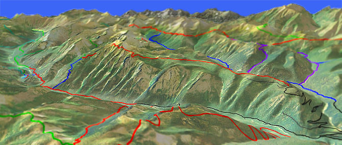
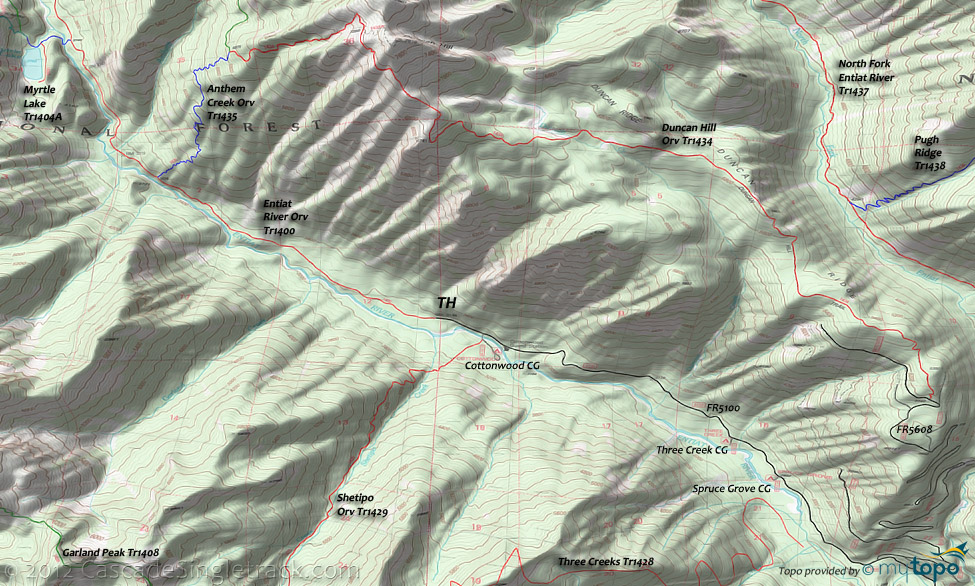
Entiat River Orv Tr1400
Twitter Search
#EntiatRiverTrail

Overall: 5
Aerobic: 4
Technical: 3
Steepness: 3
Flow: 7
Singletrack: 100%
The Ardenvoir Washington Entiat River Trail is the easy Entiat River trail option, an Orv alternative to the N. Fork Entiat Tr1437.
Type
OAB
Length
Avg: 9mi
Ascent
Moderate
Elevation Change
TH:3300'
Avg Ascent:1600'
Ascent Incline
5%
Duration
Avg: 1.5hr
Weather
Forecast
NOAA
popup
USFS
Meadows Tr1404 runs a short distance to Myrtle Lake and adds a little variety to the otherwise straightforward OAB ride.
With the help of a shuttle, Entiat River Orv Tr1400 can be used as the return for a Duncan Hill Tr1434 to Anthem Creek Tr1435 loop (2400' 1.7mi descent).
Half of the 20.5mi loop is the 3400' ascent from the Entiat River Orv Tr1400 TH to the Duncan Hill Tr1434, with a 3200' ascent remaining if shuttling between trailheads.
For those seeking backcountry terrain, Shetipo Tr1429 and Three Creeks Tr1428 can be combined into a CCW loop, but be aware that these trails are not ridden very much so depending on the season may be unrideable.
Wilderness Hiking: Entiat River Tr1400 extends into the Glacier Peak Wilderness area, to the Entiat Glacier, with major backcountry hiking loops around Pomas Pass, Borealis Ridge and Spectacle Buttes.
Area Camping on FR5100, from north to south: Cottonwood CG, Three Creek CG, Spruce Grove CG, North Fork CG, Silver Falls CG, Lake Creek CG, Fox Creek CG.
Directions: NW Forest Pass required right at the TH. From Ardenvoir continue on FR51 to FR5100 to Cottonwood CG. FR5100 ends at the TH. View Larger Map. No Map?.

OAB Directions
too easy?
- TH: Easy climb from the TH, passing Anthem Creek Tr1435 at 2.2mi and reaching Meadow Tr1404 at 3.6mi.
- 3.7mi: At Meadow Tr1404, ride out to Myrtle Lake and/or ride .8mi further to the wilderness boundary, then return to the TH.
Trail Index
This Ride
Anthem Creek Trail 1435, Duncan Hill Trail 1434, Entiat River Trail 1400, Myrtle Lake Trail 1404A
Area
Alder Ridge Trail 1523, Angle Peak Orv Trail 1444, Basalt Ridge Trail 1515, Billy Creek Trail 1416, Billy Ridge Trail 1413, Blue Creek Orv Trail 1426, Butte Creek Trail 1440, Chikamin Creek Orv Trail 1534, Chiwawa Orv Trail 1548, Cougar Mountain Orv Trail 1420, Cougar Ridge Orv Trail 1418, Devils Backbone Orv Trail 1448, Fern Lake Trail 1436, Four Mile Ridge Orv Trail 1445, Hunters Orv Trail 1417, Lake Creek Orv Trail 1443, Hi Yu Orv Trail 1403, Hornet Ridge Trail 1410, Jimmy Creek Trail 1419, Lost Lake Orv Trail 1421, Mad River Orv Trail 1409, Middle Tommy Orv Trail 1424, Miners Ridge Trail 1411, North Fork Entiat River Trail 1437, North Tommy Orv Trail 1425, Pugh Ridge Trail 1438, Pond Camp Trail 1409.2, Pyramid Creek Trail 1439, Pyramid Mountain Trail 1433, Pyramid View Point Trail 1441, Shetipo Orv Trail 1429, South Tommy Orv Trail 1423, Three Creeks Trail 1428, Tyee Ridge Orv Trail 1415
Wilderness
Cool Creek Trail 1431, Cow Creek Meadows Trail 1404, Dole Lakes Trail 1240.1, Emerald Park Trail 1230, Garland Peak Trail 1408, Ice Creek Trail 1405, Larch Lakes Trail 1430, 45 Mile Drive Trail 1432
Campgrounds
Cottonwood Campground, Three Creek Campground, Spruce Grove Campground, North Fork Campground
Trail Rankings
Ranking consistently applied to all of the listed trails.
- Overall Rating: Ride quality and challenge
- Aerobic: Ascent challenge
- Technical Difficulty: Terrain challenge
- Steepness: Average incline
- Flow: Uninterrupted riding
- Elevation Change: Total elevation gain
- Ride Difficulty: Terrain challenge


