
North Fork Entiat River Tr1437
Twitter Search
#EntiatRiverTrail

Overall: 9
Aerobic: 6
Technical: 6
Steepness: 5
Flow: 8
Singletrack: 100%
The Ardenvoir Washington North Fork Entiat River Trail is a moderate but technical OAB river ride to the North Fork Entiat River headwaters, which can be turned into something much more challenging when linked up with Pyramid Mtn Tr1433 and Pugh Ridge Tr1438.
Type
OAB
Length
Avg: 14mi
Ascent
Moderate
Elevation Change
TH:3950'
Avg Ascent:2600'
Ascent Incline
6%
Duration
Avg: 3hr
Weather
Forecast
NOAA
popup
USFS
Riders often stop at the Fern Lake Tr1436 TH, but the moderate North Fork Entiat River Tr1437 slope continues for another mile, then rapidly ascends to Pyramid Mtn Tr1433.
Fern Lake Tr1436 is a high mountain lake and the trail ascends 1800'...in 1mi, and that 22% wall-climbing exercise starts at 5200'.
This will be too steep for most riders, and those thinking of the steep descent will have to watch for oncoming traffic on this spur trail. Fern Lake Elevation Profile Map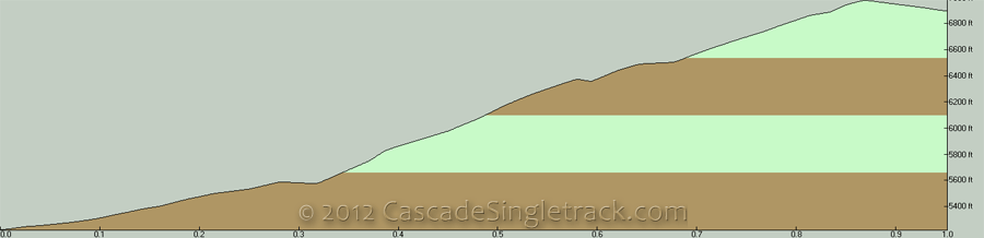
Fern Lake Elevation Profile Map.
There are several loop options, depending on climbing ability, with the 800' (.5mi) Grouse Pass ascent to consider.

Entiat, Pyramid, Pugh 18mi CW Loop (5300' ascent): The last 1mi of N. Fork Entiat Rvr Tr1437 ascends 800', a hike-a-bike for virtually anyone, but a fast way to get to Pyramid Mtn Tr1433, leaving the Grouse Pass ascent as the remaining challenge.
The final 2.5mi steep, switchback Pugh Rdg Tr1438 descent is near-epic.
Pyramid Cr/Mtn, Entiat CCW Loop: At 17mi and 4700' ascent, with 7mi of sustained climbing to Grouse Pass, this epic route is for strong climbers, or those who like to hike...a lot.
This is a way to experience N. Fork Entiat Rvr Tr1437 as a wild downhill ride, with the option of ascending the Pyramid Mountain summit on Pyramid View Point Tr1441.

Directions: NW Forest Pass required right at the TH. From Ardenvoir continue on FR51 to FR5100 to FR5606. View Larger Map. No Map?.

Loop Directions
canyon ride
North Entiat River Area Topo Map
- TH: Cross Grouse Creek, followed by 1mi of flat terrain, then a brief climb to the Pyramid Cr Tr1439 intersection at 1.2mi, just past the Pyramid Creek crossing. Cross another creek at 1.5mi, with the terrain becoming more rugged.
- 2.6mi: After crossing another creek, pass the Pugh Rdg Tr1438 intersection on the right. The ascent gets a little steeper, up to 4.5mi, then flattens out until just past the Grouse Creek crossing at 5mi.
- 5.7mi: After a steep climb from the Grouse Creek drainage, reach the Fern Lake Tr1436 intersection on the left. This is a good turnaround point, but the trail continues another mile before starting the Pyramid Mountain Tr1433 ascent. Hiking to Fern Lake is another option, then head back to the TH.

Trail Index
This Ride
Fern Lake Trail 1436, North Fork Entiat River Trail 1437, Pugh Ridge Trail 1438, Pyramid Creek Trail 1439, Pyramid Mountain Trail 1433
Area
Angle Peak Orv Trail 1444, Anthem Creek Trail 1435, Billy Creek Trail 1416, Billy Ridge Trail 1413, Blue Creek Orv Trail 1426, Butte Creek Trail 1440, Cougar Mountain Orv Trail 1420, Cougar Ridge Orv Trail 1418, Devils Backbone Orv Trail 1448, Duncan Hill Trail 1434, Entiat River Trail 1400, Four Mile Ridge Orv Trail 1445, Hunters Orv Trail 1417, Lake Creek Orv Trail 1443, Hi Yu Orv Trail 1403, Hornet Ridge Trail 1410, Jimmy Creek Trail 1419, Lost Lake Orv Trail 1421, Mad River Orv Trail 1409, Middle Tommy Orv Trail 1424, Miners Ridge Trail 1411, Myrtle Lake Trail 1404A, North Tommy Orv Trail 1425, Pond Camp Trail 1409.2, Pyramid View Point Trail 1441, Shetipo Orv Trail 1429, South Tommy Orv Trail 1423, Three Creeks Trail 1428, Tyee Ridge Orv Trail 1415
Wilderness
Emerald Park Trail 1230, Mirror Lake Tr1230.1, 45 Mile Drive Trail 1432
Campgrounds
Cottonwood Campground, North Fork Campground, Spruce Grove Campground, Three Creek Campground
Trail Rankings
Ranking consistently applied to all of the listed trails.
- Overall Rating: Ride quality and challenge
- Aerobic: Ascent challenge
- Technical Difficulty: Terrain challenge
- Steepness: Average incline
- Flow: Uninterrupted riding
- Elevation Change: Total elevation gain
- Ride Difficulty: Terrain challenge
