Hobson Horn Tr1166

Overall: 7
Aerobic: 8
Technical: 8
Steepness: 6
Flow: 5
Singletrack: 100%
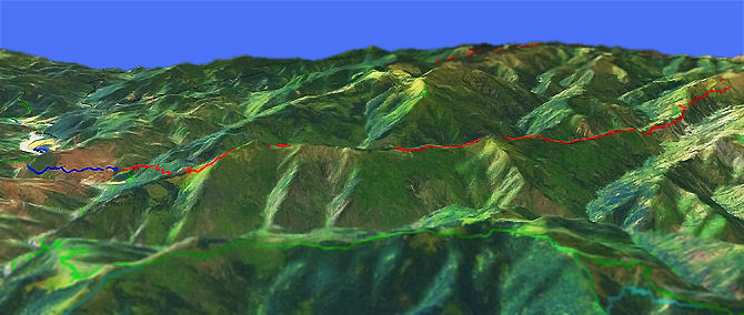
The Grants Pass Oregon Hobson Horn Trail is an epic backcountry ride..when the trail is open.
Type
OAB
Length
Avg: 26mi
Ascent
Mt Goat
Elevation Change
TH:4280'
Avg Ascent:11000'
Ascent Incline
8%
Duration
Avg: 10hr
Weather
Forecast
NOAA
popup
USFS
The trail covers an area repeatedly hit with wildfires over the past several decades, so requires some research prior to riding. Call the local forest service office and confirm maintenance and conditions.
Contact Rogue Valley MTB Assn if interested in helping with trail maintenance or for trail information.
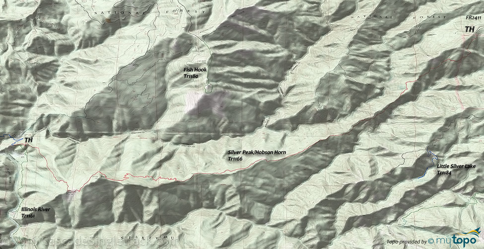
A rugged and isolated trail, with challenging switchbacks and the loose rocky ridgeline. Descend gradually for the first 3mi to a jagged, brush covered ridgeline.
Often ridden as an OAB from the Hobson Horn TH to Silver Peak, it is possible (but time consuming) to shuttle. Illinois River Tr1161 is open to bikes (from May to Sept) from the Oak Flat CG to the lower Hobson Horn Tr1166 TH
That 5mi segment of Illinois River Tr1161 includes an ascent from 250' at Indian Flat, to 1200' at Buzzards roost, for an overall 2700' ascent.
The 22mi shuttle includes 7400' ascent and 12000' descent, so should be taken very seriously, as there are no bailout points along the way. Consider taking a shelter blanket, food and other provisions. There is no water after the first 3mi.
Bear Camp Ridge Tr1147 consists of two short sections, more suitable for hiking and rarely ridden, but something to check out if camping in the area.
Trail goes 1.5mi along Bear Camp Ridge, to FR2308 and FR016 (to Elk Wallow dispersed camp), then FR2308 for a few hundred feet, then up to Elk Wallow Viewpoint.
The second TH is approximately 4.0mi further on FR2308, with a .5mi section to Craggies Viewpoint and a 4mi hike-a-bike to Squirrel Camp, which goes under Brandy Peak.
An undeveloped path accesses the peak.
Lower Rogue River Hiking
Moderate-grade hike through classic Northwest rain forest, including some 500 year old Douglas Fir.
The trail crosses a series of creeks, including a scenic waterfall at Auberry Creek.
There are some narrow sections of trail along steep cliffs
East TH: From Gold Beach, Oregon, take Jerry’s Flat Road (CR595, which becomes FR33) to Agness. Turn west on the CR375 (Old Agness Road), past the old Agness Post Office, to the Community Building TH.
Directions: NW Forest Pass required right at the TH. I-5 Merlin exit 61, then west on Merlin-Galice road. Go left onto Galice Creek Access road 34-8-36, continue for 10mi to FR2411 TH. View Larger Map. No Map?.

OAB Directions
desc
- TH: Moderate 5mi descent, passing Montana Spring at 3mi. Descent ends in a steep switchback from 2700' to 2100', the lowest elevation of the ride.
- 5mi: Ascend from the 2100' low point to 3700' over 4mi.
- 8.6mi: Ride the undulating ridgeline to Silver Peak (5100' total ascent to this point).
- 12.8mi: Turn around at Silver Peak and return to the TH.
Illinois River Trail
Illinois River Tr1161 is a chellenging hike through the north end of the Kalmiopsis Wilderness, following the river from the Oak Flat CG to the Grapevine CG, then ascending the 3700' Bald Mountain before returning to the river at the Briggs Creek CG.
Florence Way Tr1219A can be used to create a loop hike from the Briggs Creek CG.
This Kalmiopsis Wilderness trail offers of the best hikes in the Siskiyou National Forest. Wildflowers, old-growth trees, rugged and steep river canyons and a wide variety of wildlife, accessible nearly year-round across relatively low elevations from either TH. Bald Mountain will be snowed in, restricting full access to Spring-Fall.
A new bridge was built in 2005 across Silver Creek to replace one destroyed in the Biscuit Fire.
Game Lake Tr1169, Lawson Creek Tr1173 and Pine Grove Tr1170 form a loop from Agness to Game Lake.
Illinois River Trail East Access: From Grants Pass, go south on SR199 (Redwood Highway) 18mi to Selma. Go right at the Post Office (yellow flashing light) onto CR5070 (Illinois River Road) which becomes FR4103. The road is gravel/dirt, often with pot holes. The last few miles are narrower and rugged, and high-clearance vehicles are suggested. There are some junctions to private property in the Oak Flat area. At the junction with FR4105, stay to the left to remain on FR4103.
Mosquitoes are ferocious in this area until August. Feel free to try the natural repellents, and avoid drinking carbonated drinks prior to riding, but Deet 100 may be the only protection from 'the swarm'. Expect some trailside poison oak and prepare as needed. Try using Tecnu before the trip.
Trail Index
This Ride
Hobson Horn Trail 1166
Area
Kalmiopsis Wilderness Hiking
Collier Bar Trail 1182, Illinois River Trail 1161, Fish Hook Trail 1180, Florence Way Trail 1219, Game Lake Trail 1169, Horse Sign Butte Way Trail 1175, Lawson Creek Trail 1173, Lower Rogue River Trail 1168, Pine Grove Trail 1170, Pupps Camp Trail 1174, Shorty Noble Way Trail 1185, South Bend Mountain Way Trail 1189
Campgrounds
Briggs Creek Campgeound, Oak Flat Campground, Quosatana Campground
Trail Rankings
Ranking consistently applied to all of the listed trails.
- Overall Rating: Ride quality and challenge
- Aerobic: Ascent challenge
- Technical Difficulty: Terrain challenge
- Steepness: Average incline
- Flow: Uninterrupted riding
- Elevation Change: Total elevation gain
- Ride Difficulty: Terrain challenge


