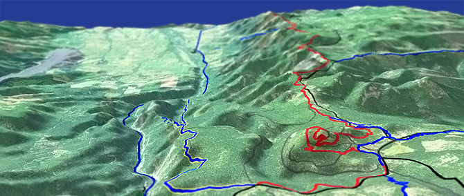
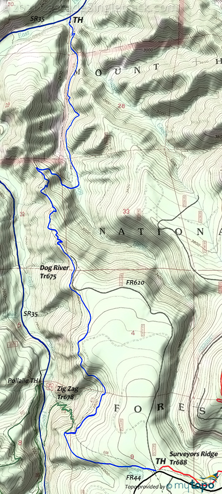
Dog River Tr675
Twitter Search
#dogrivertrail

Overall: 7
Aerobic: 7
Technical: 6
Steepness: 7
Flow: 6
Singletrack: 100%
Although not long enough to be a destination trail, the Mount Hood Oregon Dog River Trail offers some exciting, relentless downhill.
Type
OAB
Length
Avg: 12mi
Ascent
Intense
Elevation Change
TH:2150'
Avg Ascent:4000'
Ascent Incline
11%
Duration
Avg: 2.5hr
Weather
Forecast
NOAA
popup
USFS
The trail can be combined with Surveyors Rdg Tr688, Oak Rdg Tr688A (and some SR35 riding) to create an epic loop (described on the Surveyors Rdg Tr688 page).
Due to the steepness of Oak Ridge Tr688A, that loop must be done CCW, leaving Dog River Tr675 as an uphill climb.
To experience the Dog River Tr675 downhill, ride OAB from the SR35 Dog River trailhead.
Dog River Tr675 is an easy shuttle ride and so is often used by downhillers, so be aware of fast moving riders.
The trail can get chewed up and dusty as the season progresses.
Try this one 3 or 4 days after it has rained, once the trail has dried out a little.
For camping, check out the Fifteenmile Creek CG or the Eightmile CG.
Directions: NW Forest Pass required right at the TH. Pass the Parkdale ranger station and continue south on SR35 to the trailhead at Milepost 78. View Larger Map. No Map?.

OAB Directions
fast and exposed
The following describes the descent. On the ascent, after crossing Puppy Creek, there is a challenging ridgeline ascent section which may require some hike-a-bike.
- Surveyors Ridge FR44 TH: The first mile includes some water bars/speed bumps, depending on FS maintenance.
- 2.2mi: trail briefly merges with FR620, then switchbacks to the left. Trail becomes steep and technical, with some cliff exposure.
- 4.1mi: Cross Dog River, climb, descend, then cross Puppy Creek.
Trail Index
This Ride
Dog River Trail 675
Area
Bonney Meadows Trail 471, Bottle Prairie Trail 455, Boulder Lake Trail 463, Casey Creek Trail 476, Cedar Creek Trail 457, Cooks Meadow Trail 639, East Fork Trail 650, Eightmile Creek Trail 459, Fifteenmile Trail 456, Forest Creek Trail 473, Gumjuwac Trail 480, Gunsight Trail 485, Hidden Meadows Trail 472, Horkelia Meadows Trail 20, Knebal Springs Trail 474, Lookout Mountain Trail 450, Oak Ridge Trail 688A, Pocket Creek Trail 684, Surveyors Ridge Trail 688, Underhill Trail 683, Zig Zag Trail 678
Mount Hood Wilderness Hiking
XC Ski
Campgrounds
Bottle Prairie Campground, Eightmile Crossing Campground, Fifteenmile Campground, Knebal Springs Campground, Pebble Ford Campground, Robinhood Campground, Sherwood Campground
Trail Rankings
Ranking consistently applied to all of the listed trails.
- Overall Rating: Ride quality and challenge
- Aerobic: Ascent challenge
- Technical Difficulty: Terrain challenge
- Steepness: Average incline
- Flow: Uninterrupted riding
- Elevation Change: Total elevation gain
- Ride Difficulty: Terrain challenge


