
Tronsen Ridge Tr1204
Twitter Search
#TronsenRidgeTrail

Overall: 6
Aerobic: 7
Technical: 6
Steepness: 7
Flow: 5
Singletrack: 98%
Between Sheep Mountain and Mount Lillian near Blewett Pass Washington, Tronsen Ridge Tr1204 and Magnet Creek Tr1206 parallel SR97 as the road follows Tronsen Creek north of Blewett Pass, offering views of Mount Rainier, Mount Adams and St. Helens to the south as well as Glacier Peak to the North.
Type
OAB
Length
Avg: 21mi
Ascent
Intense
Elevation Change
TH:2700'
Avg Ascent:7900'
Ascent Incline
16%
Duration
Avg: 4hr
Weather
Forecast
NOAA
popup
USFS
When FR7204 is in good shape, the steepest Magnet Creek Tr1206 terrain can be avoided. For those seeking a moderate ride, starting at FR7204 and turning around 1mi past the Red Hill Tr1223 intersection (avoiding the final ascent to FR312), creates an 11mi OAB of intermediate-level, undulating ridgeline terrain.
Ding: From the SR97 Magnet Creek TH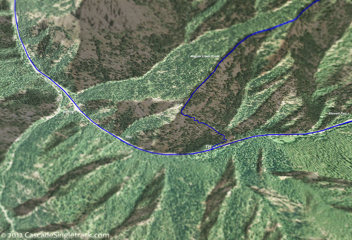
View of the Magnet Creek TH, Magnet Creek Tr1206 ascends 950' in the first .5mi, an unclimbable 36%. A very, very steep hike-a-bike, which is followed by 2mi of tough ascent, so parking at the FR7204 intersection with Magnet Creek Tr1206 is a good option if road conditions permit.
Riding from FR312 to the SR97 Magnet Creek TH creates a great 10.5mi shuttle ride. To start at FR312, drive .75mi past Haney Meadows on FR9712, to the sharp curve just before the Naneum Creek crossing, then go left on FR312 and park anywhere alongside the road.
FR7224 (Five Mile Creek Road) provides mid-trail access to Tronsen Ridge Tr1204, which could then be ridden OAB in both directions.
Limited camp sites are available at the Blewett Pass Tronsen Campground.
Magnet Creek TH: park on the west side of SR97 at MP171.2 along the shoulder (across from a rock outcrop) and go 450' down SR97 to the TH.
Directions: Drive to the top of Sauk Pass (Blewett Pass / US97) to the pullout just before MP172. Due to limited visibility, do not U-turn on SR97. The unmarked Magnet Creek TH is .7mi further uphill. View Larger Map. No Map?.

OAB Directions
nice day for a hike
- TH: Hike/crawl .5mi to the ridgeline over extremely steep terrain, then ride as much as possible along the sloping ridgeline to the 2.4mi crest, crossing a creek in the saddle between the spur ridge and Tronsen Ridge.
- 2.6mi: Go right onto FR7204, descending along the main ridgeline, crossing FR251 at 2.8mi.
- 3.6mi: At the sharp curve, go straight onto Tronsen Ridge Tr1204, descend to a saddle, then climb to a peak at 4.3mi.
- 4.8mi: Tronsen Ridge Tr1204 briefly merges with FR7224, breaking off to the left at 5mi. Go around a knoll while ascending to a 6.2mi peak, then descend to the Red Hill Tr1223 intersection at 7.1mi.
- 8.1mi: After riding along the ridge, complete the final ascent to FR312 at Upper Naneum Meadow, with a little break at 8.9mi while riding around a knoll.
- 10.3mi: Reach FR312, then return to the TH.
- Option: Continue the ride to Mount Lillian, on FR312 and Mount Lillian Tr1601.

Trail Index
This Ride
Magnet Creek Trail 1206, Tronsen Meadow Trail 1205, Tronsen Ridge Trail 1204
Area
XC Ski
Campgrounds
Tronsen Campground
Trail Rankings
Ranking consistently applied to all of the listed trails.
- Overall Rating: Ride quality and challenge
- Aerobic: Ascent challenge
- Technical Difficulty: Terrain challenge
- Steepness: Average incline
- Flow: Uninterrupted riding
- Elevation Change: Total elevation gain
- Ride Difficulty: Terrain challenge
