Blewett Pass XC Ski Trails
Twitter Search
#blewettpass

Overall: 7
Aerobic: 7
Technical: 7
Steepness: 7
Flow: 7
Singletrack: 100%
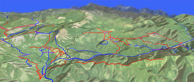
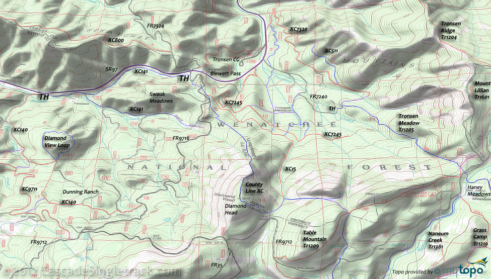
The Blewett Pass Washington XC Ski Trail system extends south from Swauk and Tronsen campgrounds, to the edge of the Naneum Rock Garden trail system.
Type
Loop
Length
Avg: 5mi
Ascent
Moderate
Elevation Change
TH:4100'
Avg Ascent:1900'
Ascent Incline
20%
Duration
Avg: 4hr
Weather
Forecast
NOAA
popup
USFS
Diamond Head has short but steep gullies on the west side (1500' descent to FR9716), and moderate avalanche risk. The south side is more moderate and the eastern slopes are typically used for descending.
The forest roads are closed in the winter and open to skiers and snowmobiles.
Check with the WA Parks Dept for the Grooming Schedule.
The 4.5mi (1000' ascent) Swauk Meadows loop doesn't wander too far from the road and offers moderate, steady terrain.
From the Swauk campground, XC-9711, XC-112 and XC-121 combine to form several substantial loops, or shuttle XC-140 to XC-9711.
Across from the Swauk Campground, XC-623 provides some creekside terrain alongside SR97.
XC trails from the Tronsen Campground tie into the 3.4mi XC-800 ridgeline trail for a moderate OAB.
The Table Mountain A-Frame Cabin is a rustic lodging option, with winter access from the top of Blewett Pass.
Cooking and eating utensils are provided as well as a Coleman cooking stove (bring 16.4oz fuel bottles), water and wood (the only heat source).
The rental fee is $50 per night through the National Recreation Reservation Service at 1-877-444-6777 or recreation.gov.
Directions: See Map. Go on SR97 to Blewett Pass, MP163.9. SnoPark pass required ($10/day, $30/season). View Larger Map. No Map?.

Loop Directions
diamondhead loop
- TH: Ascend County Line to Diamond Head then descend on XC-15. County Line starts at the first FR9716 corner, passing the Discovery TH on the left then ascending the slope alongside the creek (on the right side of the gully) then crossing FR9716.
- .1mi: Cross FR9716 at the XC-15 TH and go on XC-15 for 0.5mi. At a crest, go 100' south on XC-141 (don't descend) then ascend County Line to Diamond Point.
- 1.8mi: After a 1700' ascent, pass the Diamond Head summit and begin the descent past FR9712 at the 2.2mi Spruce Pass, reaching the XC-15 intersection. If snow conditions are good, it's possible to ski the west face of Diamond Head, to FR9716. This is not drawn on the topo map, as the route varies. The groomed FR9712 and FR35 can provide a bailout option back to Blewett Pass, if snow conditions are not good.
- 2.4mi: Go left onto XC-15 and descend Windy Gully, along a tributary of Tronsen Creek. Watch for avalanche hazards in this area.
- 3.3mi: After bearing left, away from the creek, pass several connector trails on the right while paralleling XC-7245.
- 4.3mi: Bear right at the (previously visited) intersection with County Line and ski downhill to the TH.
Trail Index
XC Ski
County Line, XC-006 Swauk Sno Park, XC-15, XC-111, XC-121, XC-140, XC-141, XC-623, XC-800, XC-7245, XC-7320, XC-9715
Area
Naneum Creek Trail 1381, Grass Camp Tie Trail 1219.1, Grass Camp Trail 1219, Howard Creek Trail 1372, Howard Creek Tie Trail 1373.2, Grouse Spring Trail 1373.1, First Creek Trail 1374, Old Ellensburg Trail 1373, Mount Lillian Trail 1601, Naneum Rim Trail 1234, Elk Trap Springs Trail 1319, Table Mountain Trail 1209
Orv
FR9716,FR9712
Campgrounds
Swauk Campground, Tronsen Campground
Trail Rankings
Ranking consistently applied to all of the listed trails.
- Overall Rating: Ride quality and challenge
- Aerobic: Ascent challenge
- Technical Difficulty: Terrain challenge
- Steepness: Average incline
- Flow: Uninterrupted riding
- Elevation Change: Total elevation gain
- Ride Difficulty: Terrain challenge


